![](/images/other/stat-length.png)
![Trail Walking Salazie - GR® R3 Le Tour de Mafate - RF13 du Haut Mafate à Marla - Photo](https://media.geolcdn.com/t/1900/400/ext.pjpeg?maxdim=2&url=https%3A%2F%2Fservices.sitytrail.com%2FGeolivesWS%2FDownloadMedia.ashx%3FTrailID%3D316705%26Media%3D4039_1.jpg)
GR® R3 Le Tour de Mafate - RF13 du Haut Mafate à Marla
tracegps
User
![Length](/images/other/stat-length.png)
![Max alt](https://static1.geolcdn.com/siteimages/upload/files/1508320355ic_sort_altitude_max_24dp.png)
![Uphill gradient](https://static1.geolcdn.com/siteimages/upload/files/1508320355ic_sort_den_pos_24dp.png)
![Km-Effort](/images/other/stat-length.png)
![Min alt](https://static1.geolcdn.com/siteimages/upload/files/1508320355ic_sort_altitude_min_24dp.png)
![Downhill gradient](https://static1.geolcdn.com/siteimages/upload/files/1508320355ic_sort_den_neg_24dp.png)
![Boucle](https://static1.geolcdn.com/siteimages/upload/files/16400158638029165_repeat_loop_refresh_sync_direction_icon.png)
![Walking](https://static1.geolcdn.com/sitytour/trail-icons/101.png)
2h10
Difficulty : Medium
![Scan this QR Code to open this trail in the SityTrail application](https://capi.geolives.com/qq0zvz2zws4bq2lad0pu/sitytour/trails/316705/qr.png?size=200)
FREE GPS app for hiking
About
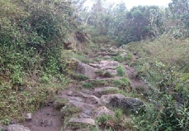
Trail Walking of 6.7 km to be discovered at Réunion, Unknown, Salazie. This trail is proposed by tracegps.
Description
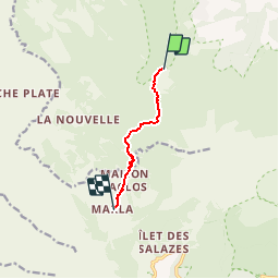
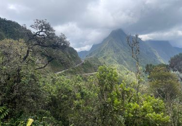
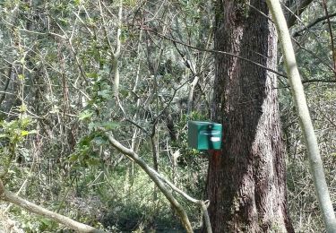
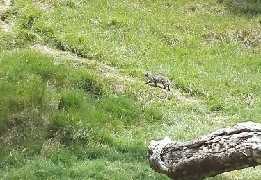
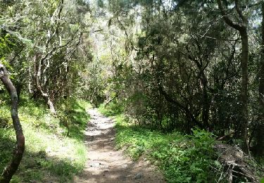
GR® R3 Le Tour de Mafate - RF13 du Haut Mafate à Marla Le cirque de Mafate est bordé d'un rempart abrupt qui préserve les îlets pittoresques accrochés aux maigres terres instables de ses hauts plateaux isolés. Le vécu d'antan, qu'aucune route ne vient troubler, garantit le charme de cet archipel intérieur dont le marcheur goûtera l'âpreté et l'authenticité. La magie des panoramas, les canyons impressionnants ponctuent le trajet d'autant de flashes inoubliables. Le sentier " Tour de Mafate" , un rêve longtemps caressé, s'est concrétisé en 2005 avec une longueur de 47,5 km. Eviter la période de l'été austral (décembre-avril) plus sujette aux pluies et typhons. Vous trouverez le descriptif détaillé de cette randonnée dans le Topo-guide® de la Fédération Française de la Randonnée Pédestre.
Positioning
Comments
Trails nearby
![Trail Walking La Possession - 2023 11 15 Marlat au parking - réalisé - Photo](https://media.geolcdn.com/t/375/260/093af69e-78fe-41c7-acee-69db22f464ab.jpg&format=jpg&maxdim=2)
![Walking Walking](https://static1.geolcdn.com/sitytour/trail-icons/101.png)
Walking
![](/images/other/stat-length.png)
![](https://static1.geolcdn.com/siteimages/upload/files/16400158638029165_repeat_loop_refresh_sync_direction_icon.png)
![Trail Walking La Possession - GRR3 Tour du cirque de Mafate (Ile de la Réunion) - Photo](https://media.geolcdn.com/t/375/260/ext.jpg?maxdim=2&url=https%3A%2F%2Fstatic1.geolcdn.com%2Fsiteimages%2Fupload%2Ffiles%2F1553511878bg_sport_marche.png)
![Walking Walking](https://static1.geolcdn.com/sitytour/trail-icons/101.png)
Walking
![](/images/other/stat-length.png)
![](https://static1.geolcdn.com/siteimages/upload/files/16400158638029165_repeat_loop_refresh_sync_direction_icon.png)
![Trail Walking La Possession - grand place la nouvelle - Photo](https://media.geolcdn.com/t/375/260/04480c93-eabe-4d3e-95a1-2ed8fc91883e.jpg&format=jpg&maxdim=2)
![Walking Walking](https://static1.geolcdn.com/sitytour/trail-icons/101.png)
Walking
![](/images/other/stat-length.png)
![](https://static1.geolcdn.com/siteimages/upload/files/16400158638029165_repeat_loop_refresh_sync_direction_icon.png)
![Trail Walking La Possession - Retour au col des Bœufs depuis Marla - Photo](https://media.geolcdn.com/t/375/260/5c26a42b-9e4b-443c-ba55-6932a3b794df.jpg&format=jpg&maxdim=2)
![Walking Walking](https://static1.geolcdn.com/sitytour/trail-icons/101.png)
Walking
![](/images/other/stat-length.png)
![](https://static1.geolcdn.com/siteimages/upload/files/16400158638029165_repeat_loop_refresh_sync_direction_icon.png)
![Trail Walking La Possession - Marla par la Nouvelle du col des boeufs - Photo](https://media.geolcdn.com/t/375/260/2abc061b-808c-493f-ac85-52fe51c0cea2.jpg&format=jpg&maxdim=2)
![Walking Walking](https://static1.geolcdn.com/sitytour/trail-icons/101.png)
Walking
![](/images/other/stat-length.png)
![](https://static1.geolcdn.com/siteimages/upload/files/16400158638029165_repeat_loop_refresh_sync_direction_icon.png)
![Trail Walking La Possession - La Réunion - Retour de Mafate (Marla) à la route d'îlet à Cordes par le col du Taïbit. - Photo](https://media.geolcdn.com/t/375/260/ext.jpg?maxdim=2&url=https%3A%2F%2Fservices.sitytrail.com%2FGeolivesWS%2FDownloadMedia.ashx%3FTrailID%3D683948%26Media%3Dfix__20170113122737.jpg)
![Walking Walking](https://static1.geolcdn.com/sitytour/trail-icons/101.png)
Walking
![](/images/other/stat-length.png)
![](https://static1.geolcdn.com/siteimages/upload/files/16400158638029165_repeat_loop_refresh_sync_direction_icon.png)
![Trail Walking La Possession - La Réunion - Mafate - Photo](https://media.geolcdn.com/t/375/260/ext.jpg?maxdim=2&url=https%3A%2F%2Fservices.sitytrail.com%2FGeolivesWS%2FDownloadMedia.ashx%3FTrailID%3D570572%26Media%3Dfix__20160514130451.jpg)
![Walking Walking](https://static1.geolcdn.com/sitytour/trail-icons/101.png)
Walking
![](/images/other/stat-length.png)
![](https://static1.geolcdn.com/siteimages/upload/files/16400158638029165_repeat_loop_refresh_sync_direction_icon.png)
![Trail Walking La Possession - La Réunion - Boucle Mafate par le Col des boeufs - Photo](https://media.geolcdn.com/t/375/260/ext.jpg?maxdim=2&url=https%3A%2F%2Fservices.sitytrail.com%2FGeolivesWS%2FDownloadMedia.ashx%3FTrailID%3D570571%26Media%3Dfix__20160514130451.jpg)
![Walking Walking](https://static1.geolcdn.com/sitytour/trail-icons/101.png)
Walking
![](/images/other/stat-length.png)
![](https://static1.geolcdn.com/siteimages/upload/files/16400158638029165_repeat_loop_refresh_sync_direction_icon.png)
![Trail Walking La Possession - La Réunion - Marla - retour par le col des boeufs - Photo](https://media.geolcdn.com/t/375/260/ext.jpg?maxdim=2&url=https%3A%2F%2Fservices.sitytrail.com%2FGeolivesWS%2FDownloadMedia.ashx%3FTrailID%3D570293%26Media%3Dfix__20160515153041.jpg)
![Walking Walking](https://static1.geolcdn.com/sitytour/trail-icons/101.png)
Walking
![](/images/other/stat-length.png)
![](https://static1.geolcdn.com/siteimages/upload/files/16400158638029165_repeat_loop_refresh_sync_direction_icon.png)