![](/images/other/stat-length.png)
![Trail Walking Groslay - La Ceinture Verte de Groslay à Chelles - Photo](https://media.geolcdn.com/t/1900/400/ext.pjpeg?maxdim=2&url=https%3A%2F%2Fservices.sitytrail.com%2FGeolivesWS%2FDownloadMedia.ashx%3FTrailID%3D316687%26Media%3D3832_1.jpg)
La Ceinture Verte de Groslay à Chelles
tracegps
User
![Length](/images/other/stat-length.png)
Length
45 km
![Max alt](https://static1.geolcdn.com/siteimages/upload/files/1508320355ic_sort_altitude_max_24dp.png)
Max alt
132 m
![Uphill gradient](https://static1.geolcdn.com/siteimages/upload/files/1508320355ic_sort_den_pos_24dp.png)
Uphill gradient
466 m
![Km-Effort](/images/other/stat-length.png)
Km-Effort
51 km
![Min alt](https://static1.geolcdn.com/siteimages/upload/files/1508320355ic_sort_altitude_min_24dp.png)
Min alt
34 m
![Downhill gradient](https://static1.geolcdn.com/siteimages/upload/files/1508320355ic_sort_den_neg_24dp.png)
Downhill gradient
481 m
![Boucle](https://static1.geolcdn.com/siteimages/upload/files/16400158638029165_repeat_loop_refresh_sync_direction_icon.png)
Boucle
No
Creation date :
2014-12-10 00:00:00.0
Updated on :
2014-12-10 00:00:00.0
![Walking](https://static1.geolcdn.com/sitytour/trail-icons/101.png)
10h45
Difficulty : Difficult
![Scan this QR Code to open this trail in the SityTrail application](https://capi.geolives.com/qq0zvz2zws4bq2lad0pu/sitytour/trails/316687/qr.png?size=200)
FREE GPS app for hiking
About
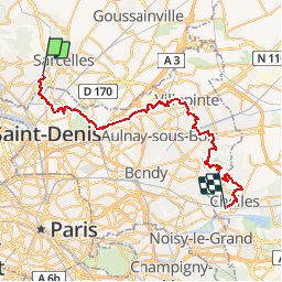
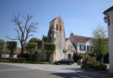
Trail Walking of 45 km to be discovered at Ile-de-France, Val-d'Oise, Groslay. This trail is proposed by tracegps.
Description
Une partie de l'itinéraire de 250km qui fait le tour de l'Île de France. Cette partie traverse la Seine Saint Denis de Pierrefitte à Montfermeil et permet de parcourir les trois grands parcs de la Courneuve, du Sausset et de Sevran.
Positioning
Country:
France
Region :
Ile-de-France
Department/Province :
Val-d'Oise
Municipality :
Groslay
Location:
Unknown
Start:(Dec)
Start:(UTM)
452842 ; 5426008 (31U) N.
Comments
Trails nearby
![Trail Walking La Courneuve - GRP CV-IDF 2023 - Photo](https://media.geolcdn.com/t/375/260/7a4519de-23cf-421c-99a8-e8d2c57d2756.jpg&format=jpg&maxdim=2)
![Walking Walking](https://static1.geolcdn.com/sitytour/trail-icons/101.png)
GRP CV-IDF 2023
Walking
Difficult
(1)
La Courneuve,
Ile-de-France,
Seine-Saint-Denis,
France
![](/images/other/stat-length.png)
16 km | 17.7 km-effort
4h 1min
![](https://static1.geolcdn.com/siteimages/upload/files/16400158638029165_repeat_loop_refresh_sync_direction_icon.png)
No
![Trail Walking Montmorency - GRP CV-IDF 2023 - Photo](https://media.geolcdn.com/t/375/260/a7d07752-d950-48b0-81c3-07ec365c67b1.jpg&format=jpg&maxdim=2)
![Walking Walking](https://static1.geolcdn.com/sitytour/trail-icons/101.png)
GRP CV-IDF 2023
Walking
Difficult
(1)
Montmorency,
Ile-de-France,
Val-d'Oise,
France
![](/images/other/stat-length.png)
15.7 km | 17.8 km-effort
4h 2min
![](https://static1.geolcdn.com/siteimages/upload/files/16400158638029165_repeat_loop_refresh_sync_direction_icon.png)
No
![Trail Walking Ézanville - D'Ecouen à Bouffémont Moisselles, fôrets et chateaux - Photo](https://media.geolcdn.com/t/375/260/ext.jpg?maxdim=2&url=https%3A%2F%2Fstatic1.geolcdn.com%2Fsiteimages%2Fupload%2Ffiles%2F1553511878bg_sport_marche.png)
![Walking Walking](https://static1.geolcdn.com/sitytour/trail-icons/101.png)
D'Ecouen à Bouffémont Moisselles, fôrets et chateaux
Walking
Difficult
(1)
Ézanville,
Ile-de-France,
Val-d'Oise,
France
![](/images/other/stat-length.png)
14.2 km | 18.2 km-effort
4h 8min
![](https://static1.geolcdn.com/siteimages/upload/files/16400158638029165_repeat_loop_refresh_sync_direction_icon.png)
No
![Trail Walking Groslay - SityTrail - GRP CV-IDF - Photo](https://media.geolcdn.com/t/375/260/a37735ed-52ba-45d2-bc83-78ca281ae5cd.jpg&format=jpg&maxdim=2)
![Walking Walking](https://static1.geolcdn.com/sitytour/trail-icons/101.png)
SityTrail - GRP CV-IDF
Walking
Medium
Groslay,
Ile-de-France,
Val-d'Oise,
France
![](/images/other/stat-length.png)
19.7 km | 24 km-effort
5h 17min
![](https://static1.geolcdn.com/siteimages/upload/files/16400158638029165_repeat_loop_refresh_sync_direction_icon.png)
No
![Trail Mountain bike Domont - La Domontoise parcours 50 Km - Photo](https://media.geolcdn.com/t/375/260/ext.jpg?maxdim=2&url=https%3A%2F%2Fservices.sitytrail.com%2FGeolivesWS%2FDownloadMedia.ashx%3FTrailID%3D317855%26Media%3D17238_6.jpg)
![Mountain bike Mountain bike](https://static1.geolcdn.com/sitytour/trail-icons/202.png)
La Domontoise parcours 50 Km
Mountain bike
Difficult
Domont,
Ile-de-France,
Val-d'Oise,
France
![](/images/other/stat-length.png)
48 km | 60 km-effort
3h 0min
![](https://static1.geolcdn.com/siteimages/upload/files/16400158638029165_repeat_loop_refresh_sync_direction_icon.png)
Yes
![Trail Mountain bike Écouen - 2010-07-27 - 11h33m30 - Photo](https://media.geolcdn.com/t/375/260/ext.jpg?maxdim=2&url=https%3A%2F%2Fservices.sitytrail.com%2FGeolivesWS%2FDownloadMedia.ashx%3FTrailID%3D42246%26Media%3Dimage2.jpg)
![Mountain bike Mountain bike](https://static1.geolcdn.com/sitytour/trail-icons/202.png)
2010-07-27 - 11h33m30
Mountain bike
Very easy
Écouen,
Ile-de-France,
Val-d'Oise,
France
![](/images/other/stat-length.png)
55 km | 65 km-effort
Unknown
![](https://static1.geolcdn.com/siteimages/upload/files/16400158638029165_repeat_loop_refresh_sync_direction_icon.png)
Yes
![Trail Walking Montmorency - Fort de Domont_château de la chasse - Photo](https://media.geolcdn.com/t/375/260/ext.jpg?maxdim=2&url=https%3A%2F%2Fservices.sitytrail.com%2FGeolivesWS%2FDownloadMedia.ashx%3FTrailID%3D943738%26Media%3D)
![Walking Walking](https://static1.geolcdn.com/sitytour/trail-icons/101.png)
Fort de Domont_château de la chasse
Walking
Easy
Montmorency,
Ile-de-France,
Val-d'Oise,
France
![](/images/other/stat-length.png)
13.1 km | 16.5 km-effort
3h 48min
![](https://static1.geolcdn.com/siteimages/upload/files/16400158638029165_repeat_loop_refresh_sync_direction_icon.png)
No
![Trail Mountain bike Montlignon - piscop - Photo](https://media.geolcdn.com/t/375/260/ext.jpg?maxdim=2&url=https%3A%2F%2Fservices.sitytrail.com%2FGeolivesWS%2FDownloadMedia.ashx%3FTrailID%3D160606%26Media%3D20121031121615.jpg)
![Mountain bike Mountain bike](https://static1.geolcdn.com/sitytour/trail-icons/202.png)
piscop
Mountain bike
Very easy
Montlignon,
Ile-de-France,
Val-d'Oise,
France
![](/images/other/stat-length.png)
18.2 km | 24 km-effort
2h 40min
![](https://static1.geolcdn.com/siteimages/upload/files/16400158638029165_repeat_loop_refresh_sync_direction_icon.png)
No
![Trail Running Andilly - forêt montmorency - Photo](https://media.geolcdn.com/t/375/260/ext.jpg?maxdim=2&url=https%3A%2F%2Fservices.sitytrail.com%2FGeolivesWS%2FDownloadMedia.ashx%3FTrailID%3D133311%26Media%3D20120610103959.jpg)
![Running Running](https://static1.geolcdn.com/sitytour/trail-icons/103.png)
forêt montmorency
Running
Medium
Andilly,
Ile-de-France,
Val-d'Oise,
France
![](/images/other/stat-length.png)
13 km | 16.6 km-effort
1h 18min
![](https://static1.geolcdn.com/siteimages/upload/files/16400158638029165_repeat_loop_refresh_sync_direction_icon.png)
Yes