![](/images/other/stat-length.png)
![Trail Walking Fontaine-le-Port - De Fontaine le Port aux rochers de Fontainebleau - Photo](https://media.geolcdn.com/t/1900/400/ext.pjpeg?maxdim=2&url=https%3A%2F%2Fservices.sitytrail.com%2FGeolivesWS%2FDownloadMedia.ashx%3FTrailID%3D316680%26Media%3D3808_1.jpg)
De Fontaine le Port aux rochers de Fontainebleau
tracegps
User
![Length](/images/other/stat-length.png)
Length
15.9 km
![Max alt](https://static1.geolcdn.com/siteimages/upload/files/1508320355ic_sort_altitude_max_24dp.png)
Max alt
130 m
![Uphill gradient](https://static1.geolcdn.com/siteimages/upload/files/1508320355ic_sort_den_pos_24dp.png)
Uphill gradient
224 m
![Km-Effort](/images/other/stat-length.png)
Km-Effort
18.8 km
![Min alt](https://static1.geolcdn.com/siteimages/upload/files/1508320355ic_sort_altitude_min_24dp.png)
Min alt
39 m
![Downhill gradient](https://static1.geolcdn.com/siteimages/upload/files/1508320355ic_sort_den_neg_24dp.png)
Downhill gradient
196 m
![Boucle](https://static1.geolcdn.com/siteimages/upload/files/16400158638029165_repeat_loop_refresh_sync_direction_icon.png)
Boucle
No
Creation date :
2014-12-10 00:00:00.0
Updated on :
2014-12-10 00:00:00.0
![Walking](https://static1.geolcdn.com/sitytour/trail-icons/101.png)
4h15
Difficulty : Difficult
![Scan this QR Code to open this trail in the SityTrail application](https://capi.geolives.com/qq0zvz2zws4bq2lad0pu/sitytour/trails/316680/qr.png?size=200)
FREE GPS app for hiking
About
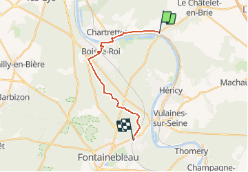
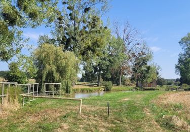
Trail Walking of 15.9 km to be discovered at Ile-de-France, Seine-et-Marne, Fontaine-le-Port. This trail is proposed by tracegps.
Description
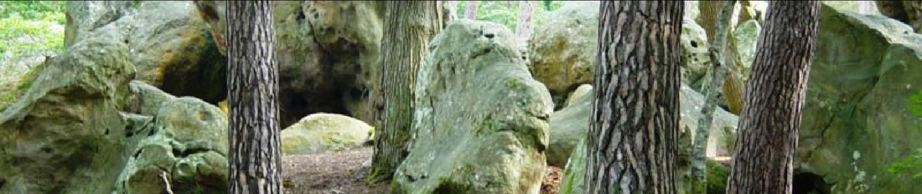
Une balade pour découvrir la Forêt de Fontainebleau, d’abord en balcon le long de la vallée de la Seine, puis à travers ses futaies jusqu’à la Tour Denecourt d'où on pourra profiter d'un vaste panorama. Crédit photo: aaff.org
Positioning
Country:
France
Region :
Ile-de-France
Department/Province :
Seine-et-Marne
Municipality :
Fontaine-le-Port
Location:
Unknown
Start:(Dec)
Start:(UTM)
481718 ; 5370441 (31U) N.
Comments
Trails nearby
![Trail Walking Bois-le-Roi - 170822 - RECO BoisLeRoi-Cmcas - Photo](https://media.geolcdn.com/t/375/260/ext.jpg?maxdim=2&url=https%3A%2F%2Fservices.sitytrail.com%2FGeolivesWS%2FDownloadMedia.ashx%3FTrailID%3D815573%26Media%3Dfix__20170822110103.jpg)
![Walking Walking](https://static1.geolcdn.com/sitytour/trail-icons/101.png)
170822 - RECO BoisLeRoi-Cmcas
Walking
Very easy
(1)
Bois-le-Roi,
Ile-de-France,
Seine-et-Marne,
France
![](/images/other/stat-length.png)
8.7 km | 10 km-effort
2h 41min
![](https://static1.geolcdn.com/siteimages/upload/files/16400158638029165_repeat_loop_refresh_sync_direction_icon.png)
Yes
![Trail Walking Fontainebleau - 131204-GLM - CxToulouse-StLouis - Photo](https://media.geolcdn.com/t/375/260/ext.jpg?maxdim=2&url=https%3A%2F%2Fservices.sitytrail.com%2FGeolivesWS%2FDownloadMedia.ashx%3FTrailID%3D235773%26Media%3Df4996202-b0e3-463d-bbc3-f9ae550a1c06.jpg)
![Walking Walking](https://static1.geolcdn.com/sitytour/trail-icons/101.png)
131204-GLM - CxToulouse-StLouis
Walking
Easy
(3)
Fontainebleau,
Ile-de-France,
Seine-et-Marne,
France
![](/images/other/stat-length.png)
9 km | 10.7 km-effort
3h 0min
![](https://static1.geolcdn.com/siteimages/upload/files/16400158638029165_repeat_loop_refresh_sync_direction_icon.png)
Yes
![Trail Walking Le Châtelet-en-Brie - Boucle 27 km au départ de Le Châtelet en Brie - Photo](https://media.geolcdn.com/t/375/260/cf6d5820-8f70-4962-a5a6-d847271ff8b0.jpg&format=jpg&maxdim=2)
![Walking Walking](https://static1.geolcdn.com/sitytour/trail-icons/101.png)
Boucle 27 km au départ de Le Châtelet en Brie
Walking
Difficult
Le Châtelet-en-Brie,
Ile-de-France,
Seine-et-Marne,
France
![](/images/other/stat-length.png)
28 km | 32 km-effort
5h 51min
![](https://static1.geolcdn.com/siteimages/upload/files/16400158638029165_repeat_loop_refresh_sync_direction_icon.png)
Yes
![Trail Walking Fontainebleau - Boucle Fontainebleau 19 km au départ de la Croix de Toulouse - Photo](https://media.geolcdn.com/t/375/260/d79877dd-2592-4558-9d21-1c3d73e08b9b.jpg&format=jpg&maxdim=2)
![Walking Walking](https://static1.geolcdn.com/sitytour/trail-icons/101.png)
Boucle Fontainebleau 19 km au départ de la Croix de Toulouse
Walking
Very difficult
Fontainebleau,
Ile-de-France,
Seine-et-Marne,
France
![](/images/other/stat-length.png)
19.1 km | 23 km-effort
4h 26min
![](https://static1.geolcdn.com/siteimages/upload/files/16400158638029165_repeat_loop_refresh_sync_direction_icon.png)
Yes
![Trail Walking Fontaine-le-Port - Boucle 25 KM depuis Fontaine le port - Photo](https://media.geolcdn.com/t/375/260/3e4be675-f0b6-4974-97b7-f69d9de03b5c.jpg&format=jpg&maxdim=2)
![Walking Walking](https://static1.geolcdn.com/sitytour/trail-icons/101.png)
Boucle 25 KM depuis Fontaine le port
Walking
Very difficult
Fontaine-le-Port,
Ile-de-France,
Seine-et-Marne,
France
![](/images/other/stat-length.png)
25 km | 29 km-effort
5h 50min
![](https://static1.geolcdn.com/siteimages/upload/files/16400158638029165_repeat_loop_refresh_sync_direction_icon.png)
Yes
![Trail Walking Féricy - Boucle Hericy 28 km - Photo](https://media.geolcdn.com/t/375/260/18b1f29d-7e5b-47c2-95d4-27af4fa3185b.jpg&format=jpg&maxdim=2)
![Walking Walking](https://static1.geolcdn.com/sitytour/trail-icons/101.png)
Boucle Hericy 28 km
Walking
Very difficult
Féricy,
Ile-de-France,
Seine-et-Marne,
France
![](/images/other/stat-length.png)
28 km | 32 km-effort
5h 54min
![](https://static1.geolcdn.com/siteimages/upload/files/16400158638029165_repeat_loop_refresh_sync_direction_icon.png)
Yes
![Trail On foot Samois-sur-Seine - Sentier Denecourt-Colinet 15 - Photo](https://media.geolcdn.com/t/375/260/0f6a8269-d3a9-4e13-9f62-8166bdbbe4ed.jpeg&format=jpg&maxdim=2)
![On foot On foot](https://static1.geolcdn.com/sitytour/trail-icons/100.png)
Sentier Denecourt-Colinet 15
On foot
Easy
Samois-sur-Seine,
Ile-de-France,
Seine-et-Marne,
France
![](/images/other/stat-length.png)
7.8 km | 8.9 km-effort
2h 1min
![](https://static1.geolcdn.com/siteimages/upload/files/16400158638029165_repeat_loop_refresh_sync_direction_icon.png)
No
![Trail Walking Chartrettes - Boucle 20 km autour de Chartrettes - Photo](https://media.geolcdn.com/t/375/260/b04db295-04e4-48e9-8daa-b62583fbe9b3.jpg&format=jpg&maxdim=2)
![Walking Walking](https://static1.geolcdn.com/sitytour/trail-icons/101.png)
Boucle 20 km autour de Chartrettes
Walking
Very easy
Chartrettes,
Ile-de-France,
Seine-et-Marne,
France
![](/images/other/stat-length.png)
19.9 km | 23 km-effort
4h 32min
![](https://static1.geolcdn.com/siteimages/upload/files/16400158638029165_repeat_loop_refresh_sync_direction_icon.png)
Yes
![Trail Walking Le Châtelet-en-Brie - Boucle champêtre autour de Chatelet en Brie - Photo](https://media.geolcdn.com/t/375/260/2deed9ba-1bb0-43ec-af05-024d7863f058.jpg&format=jpg&maxdim=2)
![Walking Walking](https://static1.geolcdn.com/sitytour/trail-icons/101.png)
Boucle champêtre autour de Chatelet en Brie
Walking
Difficult
Le Châtelet-en-Brie,
Ile-de-France,
Seine-et-Marne,
France
![](/images/other/stat-length.png)
29 km | 32 km-effort
5h 34min
![](https://static1.geolcdn.com/siteimages/upload/files/16400158638029165_repeat_loop_refresh_sync_direction_icon.png)
Yes