![](/images/other/stat-length.png)
![Trail Châtenay - 2022-03-14_16h00m10_boucle-chatenay-3 - Photo](https://media.geolcdn.com/t/1900/400/ext.pjpeg?maxdim=2&url=https%3A%2F%2Fsecurestorage.geolives.com%2Fsitytour%2Ftrail-bg%2Fdefault.jpg)
2022-03-14_16h00m10_boucle-chatenay-3
Pascale Pâris
User
![Length](/images/other/stat-length.png)
Length
34 km
![Max alt](https://static1.geolcdn.com/siteimages/upload/files/1508320355ic_sort_altitude_max_24dp.png)
Max alt
319 m
![Uphill gradient](https://static1.geolcdn.com/siteimages/upload/files/1508320355ic_sort_den_pos_24dp.png)
Uphill gradient
415 m
![Km-Effort](/images/other/stat-length.png)
Km-Effort
40 km
![Min alt](https://static1.geolcdn.com/siteimages/upload/files/1508320355ic_sort_altitude_min_24dp.png)
Min alt
248 m
![Downhill gradient](https://static1.geolcdn.com/siteimages/upload/files/1508320355ic_sort_den_neg_24dp.png)
Downhill gradient
415 m
![Boucle](https://static1.geolcdn.com/siteimages/upload/files/16400158638029165_repeat_loop_refresh_sync_direction_icon.png)
Boucle
Yes
Creation date :
2022-03-14 15:00:11.002
Updated on :
2022-03-14 15:00:12.311
![Scan this QR Code to open this trail in the SityTrail application](https://capi.geolives.com/qq0zvz2zws4bq2lad0pu/sitytour/trails/3166723/qr.png?size=200)
FREE GPS app for hiking
About
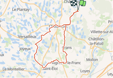
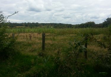
Trail of 34 km to be discovered at Auvergne-Rhône-Alpes, Ain, Châtenay. This trail is proposed by Pascale Pâris.
Description
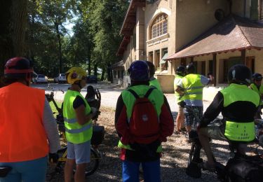
Boucle à la journée au départ du relais " La Commanderie" à Chatenay de 34 km.
Beau circuit qui rentre dans le pays des mille étangs ! Chemin roulants.
Pause café à Rignieux le Franc et joli endroit pour pique-nique vers St Eloi.
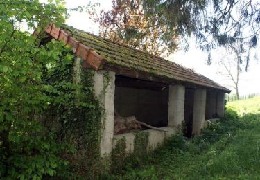
Pour cavalier.
mis à jour 02/05/2020
Positioning
Country:
France
Region :
Auvergne-Rhône-Alpes
Department/Province :
Ain
Municipality :
Châtenay
Location:
Unknown
Start:(Dec)
Start:(UTM)
671431 ; 5098803 (31T) N.
Comments
Trails nearby
![Trail Walking Châtillon-la-Palud - Petite course à pied tranquille - Châtillon la Palud - Photo](https://media.geolcdn.com/t/375/260/ext.jpg?maxdim=2&url=https%3A%2F%2Fservices.sitytrail.com%2FGeolivesWS%2FDownloadMedia.ashx%3FTrailID%3D173138%26Media%3D14698_4.jpg)
![Walking Walking](https://static1.geolcdn.com/sitytour/trail-icons/101.png)
Petite course à pied tranquille - Châtillon la Palud
Walking
Easy
(1)
Châtillon-la-Palud,
Auvergne-Rhône-Alpes,
Ain,
France
![](/images/other/stat-length.png)
6.3 km | 8.3 km-effort
1h 30min
![](https://static1.geolcdn.com/siteimages/upload/files/16400158638029165_repeat_loop_refresh_sync_direction_icon.png)
Yes
![Trail Running Châtillon-la-Palud - Petite course à pied tranquille - Châtillon la Palud - Photo](https://media.geolcdn.com/t/375/260/ext.jpg?maxdim=2&url=https%3A%2F%2Fservices.sitytrail.com%2FGeolivesWS%2FDownloadMedia.ashx%3FTrailID%3D173140%26Media%3D14698_4.jpg)
![Running Running](https://static1.geolcdn.com/sitytour/trail-icons/103.png)
Petite course à pied tranquille - Châtillon la Palud
Running
Medium
Châtillon-la-Palud,
Auvergne-Rhône-Alpes,
Ain,
France
![](/images/other/stat-length.png)
6.3 km | 8.3 km-effort
34min
![](https://static1.geolcdn.com/siteimages/upload/files/16400158638029165_repeat_loop_refresh_sync_direction_icon.png)
Yes
![Trail Mountain bike Châtillon-la-Palud - Petite course à pied tranquille - Châtillon la Palud - Photo](https://media.geolcdn.com/t/375/260/ext.jpg?maxdim=2&url=https%3A%2F%2Fservices.sitytrail.com%2FGeolivesWS%2FDownloadMedia.ashx%3FTrailID%3D173139%26Media%3D14698_4.jpg)
![Mountain bike Mountain bike](https://static1.geolcdn.com/sitytour/trail-icons/202.png)
Petite course à pied tranquille - Châtillon la Palud
Mountain bike
Easy
Châtillon-la-Palud,
Auvergne-Rhône-Alpes,
Ain,
France
![](/images/other/stat-length.png)
6.3 km | 8.3 km-effort
19min
![](https://static1.geolcdn.com/siteimages/upload/files/16400158638029165_repeat_loop_refresh_sync_direction_icon.png)
Yes
![Trail Walking Chalamont - Circuit de Chalamont - 10 km - Photo](https://media.geolcdn.com/t/375/260/ext.jpg?maxdim=2&url=https%3A%2F%2Fservices.sitytrail.com%2FGeolivesWS%2FDownloadMedia.ashx%3FTrailID%3D106824%26Media%3D11528_4.jpg)
![Walking Walking](https://static1.geolcdn.com/sitytour/trail-icons/101.png)
Circuit de Chalamont - 10 km
Walking
Medium
(1)
Chalamont,
Auvergne-Rhône-Alpes,
Ain,
France
![](/images/other/stat-length.png)
9.9 km | 11.4 km-effort
2h 30min
![](https://static1.geolcdn.com/siteimages/upload/files/16400158638029165_repeat_loop_refresh_sync_direction_icon.png)
Yes
![Trail Mountain bike Dompierre-sur-Veyle - Balade Solex autour de Dompierre sur Veyle - Photo](https://media.geolcdn.com/t/375/260/ext.jpg?maxdim=2&url=https%3A%2F%2Fservices.sitytrail.com%2FGeolivesWS%2FDownloadMedia.ashx%3FTrailID%3D1034273%26Media%3D20180819113423.jpg)
![Mountain bike Mountain bike](https://static1.geolcdn.com/sitytour/trail-icons/202.png)
Balade Solex autour de Dompierre sur Veyle
Mountain bike
Very easy
Dompierre-sur-Veyle,
Auvergne-Rhône-Alpes,
Ain,
France
![](/images/other/stat-length.png)
30 km | 33 km-effort
2h 13min
![](https://static1.geolcdn.com/siteimages/upload/files/16400158638029165_repeat_loop_refresh_sync_direction_icon.png)
Yes
![Trail Walking Chalamont - chalamont cs - Photo](https://media.geolcdn.com/t/375/260/ext.jpg?maxdim=2&url=https%3A%2F%2Fservices.sitytrail.com%2FGeolivesWS%2FDownloadMedia.ashx%3FTrailID%3D338269%26Media%3Dfix__20140823134128.jpg)
![Walking Walking](https://static1.geolcdn.com/sitytour/trail-icons/101.png)
chalamont cs
Walking
Easy
Chalamont,
Auvergne-Rhône-Alpes,
Ain,
France
![](/images/other/stat-length.png)
10.8 km | 12.4 km-effort
4h 5min
![](https://static1.geolcdn.com/siteimages/upload/files/16400158638029165_repeat_loop_refresh_sync_direction_icon.png)
Yes
![Trail Walking Druillat - le roset 1 - Photo](https://media.geolcdn.com/t/375/260/ext.jpg?maxdim=2&url=https%3A%2F%2Fstatic1.geolcdn.com%2Fsiteimages%2Fupload%2Ffiles%2F1553511878bg_sport_marche.png)
![Walking Walking](https://static1.geolcdn.com/sitytour/trail-icons/101.png)
le roset 1
Walking
Difficult
Druillat,
Auvergne-Rhône-Alpes,
Ain,
France
![](/images/other/stat-length.png)
13.4 km | 15.9 km-effort
3h 36min
![](https://static1.geolcdn.com/siteimages/upload/files/16400158638029165_repeat_loop_refresh_sync_direction_icon.png)
Yes
![Trail sport Châtenay - 2022-04-27_07h12m06_boucle-chatenay-1-2 - Photo](https://media.geolcdn.com/t/375/260/ext.jpg?maxdim=2&url=https%3A%2F%2Fsecurestorage.geolives.com%2Fsitytour%2Ftrail-bg%2Fdefault.jpg)
2022-04-27_07h12m06_boucle-chatenay-1-2
sport
Very easy
Châtenay,
Auvergne-Rhône-Alpes,
Ain,
France
![](/images/other/stat-length.png)
25 km | 28 km-effort
Unknown
![](https://static1.geolcdn.com/siteimages/upload/files/16400158638029165_repeat_loop_refresh_sync_direction_icon.png)
Yes
![Trail sport Châtenay - 2022-03-14_17h26m53_boucle-chatenay-2 - Photo](https://media.geolcdn.com/t/375/260/ext.jpg?maxdim=2&url=https%3A%2F%2Fsecurestorage.geolives.com%2Fsitytour%2Ftrail-bg%2Fdefault.jpg)
2022-03-14_17h26m53_boucle-chatenay-2
sport
Very easy
Châtenay,
Auvergne-Rhône-Alpes,
Ain,
France
![](/images/other/stat-length.png)
25 km | 29 km-effort
Unknown
![](https://static1.geolcdn.com/siteimages/upload/files/16400158638029165_repeat_loop_refresh_sync_direction_icon.png)
Yes