![](/images/other/stat-length.png)
![Trail Walking Eijsden-Margraten - Mheer - St Geertruid - Photo](https://media.geolcdn.com/t/1900/400/92c34488-bd93-431b-8608-d18743526f32.jpg&format=pjpeg&maxdim=2)
Mheer - St Geertruid
mumu.larandonneuse
User GUIDE
![Length](/images/other/stat-length.png)
![Max alt](https://static1.geolcdn.com/siteimages/upload/files/1508320355ic_sort_altitude_max_24dp.png)
![Uphill gradient](https://static1.geolcdn.com/siteimages/upload/files/1508320355ic_sort_den_pos_24dp.png)
![Km-Effort](/images/other/stat-length.png)
![Min alt](https://static1.geolcdn.com/siteimages/upload/files/1508320355ic_sort_altitude_min_24dp.png)
![Downhill gradient](https://static1.geolcdn.com/siteimages/upload/files/1508320355ic_sort_den_neg_24dp.png)
![Boucle](https://static1.geolcdn.com/siteimages/upload/files/16400158638029165_repeat_loop_refresh_sync_direction_icon.png)
![Walking](https://static1.geolcdn.com/sitytour/trail-icons/101.png)
3h03
Difficulty : Easy
![Scan this QR Code to open this trail in the SityTrail application](https://capi.geolives.com/qq0zvz2zws4bq2lad0pu/sitytour/trails/3165259/qr.png?size=200)
FREE GPS app for hiking
About
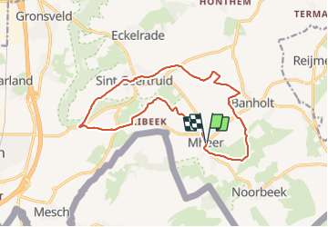
Trail Walking of 14.4 km to be discovered at Limburg, Unknown, Eijsden-Margraten. This trail is proposed by mumu.larandonneuse.
Description
Une belle randonnée campagnarde et champêtre dans le Zuid-Limburg au départ de Mheer.
Le parcours passe par Banholt qui offre de magnifiques vues panoramiques sur la cimenterie de Lixhe, Maastricht et la vallée la Meuse, puis par Herkenrade, St Geertruid et Libeek.
✔ Marche balisée du 13/03/22
ℹ Wandel.nl
Positioning
Comments
Trails nearby
![Trail Walking Eijsden-Margraten - Gulpen - Hubertusmarkt - Photo](https://media.geolcdn.com/t/375/260/6a2a5595-eb93-4f0f-8c09-6c6ead7a7201.jpg&format=jpg&maxdim=2)
![Walking Walking](https://static1.geolcdn.com/sitytour/trail-icons/101.png)
Walking
![](/images/other/stat-length.png)
![](https://static1.geolcdn.com/siteimages/upload/files/16400158638029165_repeat_loop_refresh_sync_direction_icon.png)
![Trail Walking Eijsden-Margraten - Mheer - Banholt - Hoogbos - Photo](https://media.geolcdn.com/t/375/260/1f70cdf1-9a0b-4d25-acc7-7c75993bbb86.jpg&format=jpg&maxdim=2)
![Walking Walking](https://static1.geolcdn.com/sitytour/trail-icons/101.png)
Walking
![](/images/other/stat-length.png)
![](https://static1.geolcdn.com/siteimages/upload/files/16400158638029165_repeat_loop_refresh_sync_direction_icon.png)
![Trail Walking Eijsden-Margraten - 2024-01-08_03h28m34_eijsden-margraten-e8-bloesemroute-3 - Photo](https://media.geolcdn.com/t/375/260/7792b7db-95a9-4b53-8cd5-7eae3fedc6a4.jpg&format=jpg&maxdim=2)
![Walking Walking](https://static1.geolcdn.com/sitytour/trail-icons/101.png)
Walking
![](/images/other/stat-length.png)
![](https://static1.geolcdn.com/siteimages/upload/files/16400158638029165_repeat_loop_refresh_sync_direction_icon.png)
![Trail Walking Eijsden-Margraten - 2024-01-08_03h24m36_eijsden-margraten-e5 - Photo](https://media.geolcdn.com/t/375/260/cb3c0103-7b73-4049-ab47-8594df511d3c.jpg&format=jpg&maxdim=2)
![Walking Walking](https://static1.geolcdn.com/sitytour/trail-icons/101.png)
Walking
![](/images/other/stat-length.png)
![](https://static1.geolcdn.com/siteimages/upload/files/16400158638029165_repeat_loop_refresh_sync_direction_icon.png)
![Trail Walking Voeren - Ulvend - La Planck - Noorbeek - Photo](https://media.geolcdn.com/t/375/260/1b8a3af4-c436-4943-b8e2-3197209c6144.jpg&format=jpg&maxdim=2)
![Walking Walking](https://static1.geolcdn.com/sitytour/trail-icons/101.png)
Walking
![](/images/other/stat-length.png)
![](https://static1.geolcdn.com/siteimages/upload/files/16400158638029165_repeat_loop_refresh_sync_direction_icon.png)
![Trail Walking Voeren - 2022-11-11_17h35m36_wandelroute-de-voerstreek-mooiste - Photo](https://media.geolcdn.com/t/375/260/3df743f8-88e4-4c10-a47a-c05fdf0072fe.jpg&format=jpg&maxdim=2)
![Walking Walking](https://static1.geolcdn.com/sitytour/trail-icons/101.png)
Walking
![](/images/other/stat-length.png)
![](https://static1.geolcdn.com/siteimages/upload/files/16400158638029165_repeat_loop_refresh_sync_direction_icon.png)
![Trail Walking Eijsden-Margraten - 2022-11-10_16h33m33_1327 - Photo](https://media.geolcdn.com/t/375/260/877eed2d-204c-4212-a49e-caf4fc574b56.jpg&format=jpg&maxdim=2)
![Walking Walking](https://static1.geolcdn.com/sitytour/trail-icons/101.png)
Walking
![](/images/other/stat-length.png)
![](https://static1.geolcdn.com/siteimages/upload/files/16400158638029165_repeat_loop_refresh_sync_direction_icon.png)
![Trail Walking Eijsden-Margraten - 2022-10-23_14h53m39_eijsden-margraten-e9-mesch--moerslag--mesch - Photo](https://media.geolcdn.com/t/375/260/44ba086f-f486-4631-8c1f-b562699d8ecb.jpg&format=jpg&maxdim=2)
![Walking Walking](https://static1.geolcdn.com/sitytour/trail-icons/101.png)
Walking
![](/images/other/stat-length.png)
![](https://static1.geolcdn.com/siteimages/upload/files/16400158638029165_repeat_loop_refresh_sync_direction_icon.png)
![Trail Walking Eijsden-Margraten - Mesch - Photo](https://media.geolcdn.com/t/375/260/877552c4-bc60-4040-89d8-1feef8999df8.jpg&format=jpg&maxdim=2)
![Walking Walking](https://static1.geolcdn.com/sitytour/trail-icons/101.png)
Walking
![](/images/other/stat-length.png)
![](https://static1.geolcdn.com/siteimages/upload/files/16400158638029165_repeat_loop_refresh_sync_direction_icon.png)