![](/images/other/stat-length.png)
![Trail On foot Moret-Loing-et-Orvanne - Moret/Loing-parcours Sisley - Photo](https://media.geolcdn.com/t/1900/400/ext.pjpeg?maxdim=2&url=https%3A%2F%2Fstatic1.geolcdn.com%2Fsiteimages%2Fupload%2Ffiles%2F1545311037marcheuse_200dpi.jpg)
Moret/Loing-parcours Sisley
Randos du mercredi
Le mercredi c'est rando
![Length](/images/other/stat-length.png)
Length
11.5 km
![Max alt](https://static1.geolcdn.com/siteimages/upload/files/1508320355ic_sort_altitude_max_24dp.png)
Max alt
105 m
![Uphill gradient](https://static1.geolcdn.com/siteimages/upload/files/1508320355ic_sort_den_pos_24dp.png)
Uphill gradient
111 m
![Km-Effort](/images/other/stat-length.png)
Km-Effort
13 km
![Min alt](https://static1.geolcdn.com/siteimages/upload/files/1508320355ic_sort_altitude_min_24dp.png)
Min alt
42 m
![Downhill gradient](https://static1.geolcdn.com/siteimages/upload/files/1508320355ic_sort_den_neg_24dp.png)
Downhill gradient
111 m
![Boucle](https://static1.geolcdn.com/siteimages/upload/files/16400158638029165_repeat_loop_refresh_sync_direction_icon.png)
Boucle
Yes
Creation date :
2022-03-12 11:00:48.058
Updated on :
2022-05-24 08:27:29.007
![On foot](https://static1.geolcdn.com/sitytour/trail-icons/100.png)
3h47
Difficulty : Easy
![Scan this QR Code to open this trail in the SityTrail application](https://capi.geolives.com/qq0zvz2zws4bq2lad0pu/sitytour/trails/3163982/qr.png?size=200)
FREE GPS app for hiking
About
Trail On foot of 11.5 km to be discovered at Ile-de-France, Seine-et-Marne, Moret-Loing-et-Orvanne. This trail is proposed by Randos du mercredi.
Description
Randonnée pique-nique
parking : Champs de Mars, Morez/loing
Positioning
Country:
France
Region :
Ile-de-France
Department/Province :
Seine-et-Marne
Municipality :
Moret-Loing-et-Orvanne
Location:
Moret-sur-Loing
Start:(Dec)
Start:(UTM)
486523 ; 5357957 (31U) N.
Comments
Trails nearby
![Trail Walking Champagne-sur-Seine - GLM-150507 - Champagne - Photo](https://media.geolcdn.com/t/375/260/ext.jpg?maxdim=2&url=https%3A%2F%2Fservices.sitytrail.com%2FGeolivesWS%2FDownloadMedia.ashx%3FTrailID%3D417747%26Media%3Dcf3441e3-cd65-4b43-a868-e5ea57f18914.jpg)
![Walking Walking](https://static1.geolcdn.com/sitytour/trail-icons/101.png)
GLM-150507 - Champagne
Walking
Easy
(1)
Champagne-sur-Seine,
Ile-de-France,
Seine-et-Marne,
France
![](/images/other/stat-length.png)
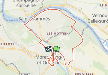
17.3 km | 20 km-effort
4h 20min
![](https://static1.geolcdn.com/siteimages/upload/files/16400158638029165_repeat_loop_refresh_sync_direction_icon.png)
Yes
![Trail Walking Fontainebleau - Boucle 30 km Veni Venelles Vici - Photo](https://media.geolcdn.com/t/375/260/ext.jpg?maxdim=2&url=https%3A%2F%2Fstatic1.geolcdn.com%2Fsiteimages%2Fupload%2Ffiles%2F1553511878bg_sport_marche.png)
![Walking Walking](https://static1.geolcdn.com/sitytour/trail-icons/101.png)
Boucle 30 km Veni Venelles Vici
Walking
Very difficult
(1)
Fontainebleau,
Ile-de-France,
Seine-et-Marne,
France
![](/images/other/stat-length.png)
30 km | 35 km-effort
6h 0min
![](https://static1.geolcdn.com/siteimages/upload/files/16400158638029165_repeat_loop_refresh_sync_direction_icon.png)
No
![Trail Walking Fontainebleau - viennes carosses - Photo](https://media.geolcdn.com/t/375/260/9b54e644-4214-4411-b7b4-ea5a49e11005.jpg&format=jpg&maxdim=2)
![Walking Walking](https://static1.geolcdn.com/sitytour/trail-icons/101.png)
viennes carosses
Walking
Very easy
(2)
Fontainebleau,
Ile-de-France,
Seine-et-Marne,
France
![](/images/other/stat-length.png)
10.8 km | 14 km-effort
2h 50min
![](https://static1.geolcdn.com/siteimages/upload/files/16400158638029165_repeat_loop_refresh_sync_direction_icon.png)
Yes
![Trail Other activity Thomery - forêt de fontainebleau - Photo](https://media.geolcdn.com/t/375/260/ext.jpg?maxdim=2&url=https%3A%2F%2Fservices.sitytrail.com%2FGeolivesWS%2FDownloadMedia.ashx%3FTrailID%3D703736%26Media%3D20170223103030.jpg)
![Other activity Other activity](https://static1.geolcdn.com/sitytour/trail-icons/900.png)
forêt de fontainebleau
Other activity
Medium
(1)
Thomery,
Ile-de-France,
Seine-et-Marne,
France
![](/images/other/stat-length.png)
20 km | 23 km-effort
5h 40min
![](https://static1.geolcdn.com/siteimages/upload/files/16400158638029165_repeat_loop_refresh_sync_direction_icon.png)
Yes
![Trail Walking Champagne-sur-Seine - Boucle Champagne/ Seine - Moret - St Mammes - Thomery - Photo](https://media.geolcdn.com/t/375/260/a76c9969-6152-4085-be7d-0578611d1cc7.jpg&format=jpg&maxdim=2)
![Walking Walking](https://static1.geolcdn.com/sitytour/trail-icons/101.png)
Boucle Champagne/ Seine - Moret - St Mammes - Thomery
Walking
Easy
Champagne-sur-Seine,
Ile-de-France,
Seine-et-Marne,
France
![](/images/other/stat-length.png)
24 km | 27 km-effort
5h 15min
![](https://static1.geolcdn.com/siteimages/upload/files/16400158638029165_repeat_loop_refresh_sync_direction_icon.png)
Yes
![Trail On foot Moret-Loing-et-Orvanne - La basse vallée du Lunain version 30 km - Photo](https://media.geolcdn.com/t/375/260/7e9d55c6-78ba-44d4-861c-7056fde52aaa.jpg&format=jpg&maxdim=2)
![On foot On foot](https://static1.geolcdn.com/sitytour/trail-icons/100.png)
La basse vallée du Lunain version 30 km
On foot
Difficult
Moret-Loing-et-Orvanne,
Ile-de-France,
Seine-et-Marne,
France
![](/images/other/stat-length.png)
30 km | 34 km-effort
7h 39min
![](https://static1.geolcdn.com/siteimages/upload/files/16400158638029165_repeat_loop_refresh_sync_direction_icon.png)
Yes
![Trail On foot Fontainebleau - Sur les traces de Rosa Bonheur - Thomery - Photo](https://media.geolcdn.com/t/375/260/324d54be-66a3-49af-bf6e-2e2e4110383f.jpg&format=jpg&maxdim=2)
![On foot On foot](https://static1.geolcdn.com/sitytour/trail-icons/100.png)
Sur les traces de Rosa Bonheur - Thomery
On foot
Medium
Fontainebleau,
Ile-de-France,
Seine-et-Marne,
France
![](/images/other/stat-length.png)
30 km | 35 km-effort
7h 53min
![](https://static1.geolcdn.com/siteimages/upload/files/16400158638029165_repeat_loop_refresh_sync_direction_icon.png)
Yes
![Trail On foot Saint-Mammès - Batellerie et foret - Photo](https://media.geolcdn.com/t/375/260/51b649c2-1598-47b6-9a5e-d0492e6f7a35.jpeg&format=jpg&maxdim=2)
![On foot On foot](https://static1.geolcdn.com/sitytour/trail-icons/100.png)
Batellerie et foret
On foot
Easy
(1)
Saint-Mammès,
Ile-de-France,
Seine-et-Marne,
France
![](/images/other/stat-length.png)
8.6 km | 9.9 km-effort
2h 14min
![](https://static1.geolcdn.com/siteimages/upload/files/16400158638029165_repeat_loop_refresh_sync_direction_icon.png)
Yes
![Trail On foot Montigny-sur-Loing - De Kosciusko à Croc Marin - Photo](https://media.geolcdn.com/t/375/260/f5bc045f-e010-4cc1-a4ef-a06cb0f8d565.jpeg&format=jpg&maxdim=2)
![On foot On foot](https://static1.geolcdn.com/sitytour/trail-icons/100.png)
De Kosciusko à Croc Marin
On foot
Medium
Montigny-sur-Loing,
Ile-de-France,
Seine-et-Marne,
France
![](/images/other/stat-length.png)
17.5 km | 21 km-effort
4h 42min
![](https://static1.geolcdn.com/siteimages/upload/files/16400158638029165_repeat_loop_refresh_sync_direction_icon.png)
Yes