![](/images/other/stat-length.png)
![Trail On foot Mennecy - Boucle autour de Mennecy - Photo](https://media.geolcdn.com/t/1900/400/8b9e4ef7-6f9c-44d6-bf15-96d045d2bf54.jpg&format=pjpeg&maxdim=2)
Boucle autour de Mennecy
chessyca
User GUIDE
![Length](/images/other/stat-length.png)
Length
27 km
![Max alt](https://static1.geolcdn.com/siteimages/upload/files/1508320355ic_sort_altitude_max_24dp.png)
Max alt
92 m
![Uphill gradient](https://static1.geolcdn.com/siteimages/upload/files/1508320355ic_sort_den_pos_24dp.png)
Uphill gradient
235 m
![Km-Effort](/images/other/stat-length.png)
Km-Effort
30 km
![Min alt](https://static1.geolcdn.com/siteimages/upload/files/1508320355ic_sort_altitude_min_24dp.png)
Min alt
46 m
![Downhill gradient](https://static1.geolcdn.com/siteimages/upload/files/1508320355ic_sort_den_neg_24dp.png)
Downhill gradient
231 m
![Boucle](https://static1.geolcdn.com/siteimages/upload/files/16400158638029165_repeat_loop_refresh_sync_direction_icon.png)
Boucle
Yes
Creation date :
2022-03-09 08:12:05.916
Updated on :
2022-03-09 17:38:43.19
![On foot](https://static1.geolcdn.com/sitytour/trail-icons/100.png)
6h48
Difficulty : Medium
![Scan this QR Code to open this trail in the SityTrail application](https://capi.geolives.com/qq0zvz2zws4bq2lad0pu/sitytour/trails/3160800/qr.png?size=200)
FREE GPS app for hiking
About
Trail On foot of 27 km to be discovered at Ile-de-France, Essonne, Mennecy. This trail is proposed by chessyca.
Description
Rando menée par Jean Marc.
Au fil de l'eau avec les étangs et marais d'Echarcon, L'aqueduc de la Vanne, etc...
Très agréable en cette saison ( pas de moustiques)
Positioning
Country:
France
Region :
Ile-de-France
Department/Province :
Essonne
Municipality :
Mennecy
Location:
Unknown
Start:(Dec)
Start:(UTM)
457526 ; 5379401 (31U) N.
Comments
Trails nearby
![Trail Walking Écharcon - Autour de Vert le Petit - Photo](https://media.geolcdn.com/t/375/260/ext.jpg?maxdim=2&url=https%3A%2F%2Fservices.sitytrail.com%2FGeolivesWS%2FDownloadMedia.ashx%3FTrailID%3D102739%26Media%3D3871_4.jpg)
![Walking Walking](https://static1.geolcdn.com/sitytour/trail-icons/101.png)
Autour de Vert le Petit
Walking
Medium
(1)
Écharcon,
Ile-de-France,
Essonne,
France
![](/images/other/stat-length.png)
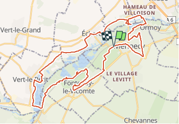
16 km | 17.9 km-effort
4h 0min
![](https://static1.geolcdn.com/siteimages/upload/files/16400158638029165_repeat_loop_refresh_sync_direction_icon.png)
Yes
![Trail On foot Mennecy - Boucle 20 km autour de Mennecy - Photo](https://media.geolcdn.com/t/375/260/a0d84bba-b7da-4081-b724-5ae5c2d178d5.jpg&format=jpg&maxdim=2)
![On foot On foot](https://static1.geolcdn.com/sitytour/trail-icons/100.png)
Boucle 20 km autour de Mennecy
On foot
Medium
Mennecy,
Ile-de-France,
Essonne,
France
![](/images/other/stat-length.png)
20 km | 23 km-effort
5h 15min
![](https://static1.geolcdn.com/siteimages/upload/files/16400158638029165_repeat_loop_refresh_sync_direction_icon.png)
Yes
![Trail Walking Ballancourt-sur-Essonne - Rando Ballancourt 15 km BM - Photo](https://media.geolcdn.com/t/375/260/8977c33c-1145-4a4f-97a7-a064e00deb0b.jpg&format=jpg&maxdim=2)
![Walking Walking](https://static1.geolcdn.com/sitytour/trail-icons/101.png)
Rando Ballancourt 15 km BM
Walking
Difficult
(1)
Ballancourt-sur-Essonne,
Ile-de-France,
Essonne,
France
![](/images/other/stat-length.png)
14.8 km | 16.9 km-effort
3h 50min
![](https://static1.geolcdn.com/siteimages/upload/files/16400158638029165_repeat_loop_refresh_sync_direction_icon.png)
Yes
![Trail Walking Mennecy - Boucle 23 km au départ de Mennecy - Photo](https://media.geolcdn.com/t/375/260/d9409c0b-4ad5-436d-94de-44694c25ec6a.jpg&format=jpg&maxdim=2)
![Walking Walking](https://static1.geolcdn.com/sitytour/trail-icons/101.png)
Boucle 23 km au départ de Mennecy
Walking
Very easy
Mennecy,
Ile-de-France,
Essonne,
France
![](/images/other/stat-length.png)
23 km | 26 km-effort
4h 52min
![](https://static1.geolcdn.com/siteimages/upload/files/16400158638029165_repeat_loop_refresh_sync_direction_icon.png)
Yes
![Trail Walking Ballancourt-sur-Essonne - Boucle autour de Ballancourt - Photo](https://media.geolcdn.com/t/375/260/726c3226-57e6-4792-b7bd-15745463bf1c.jpg&format=jpg&maxdim=2)
![Walking Walking](https://static1.geolcdn.com/sitytour/trail-icons/101.png)
Boucle autour de Ballancourt
Walking
Medium
Ballancourt-sur-Essonne,
Ile-de-France,
Essonne,
France
![](/images/other/stat-length.png)
21 km | 25 km-effort
4h 47min
![](https://static1.geolcdn.com/siteimages/upload/files/16400158638029165_repeat_loop_refresh_sync_direction_icon.png)
Yes
![Trail On foot Mennecy - Les Etangs de Mennecy - Photo](https://media.geolcdn.com/t/375/260/ext.jpg?maxdim=2&url=https%3A%2F%2Fstatic1.geolcdn.com%2Fsiteimages%2Fupload%2Ffiles%2F1545311037marcheuse_200dpi.jpg)
![On foot On foot](https://static1.geolcdn.com/sitytour/trail-icons/100.png)
Les Etangs de Mennecy
On foot
Difficult
(1)
Mennecy,
Ile-de-France,
Essonne,
France
![](/images/other/stat-length.png)
18.5 km | 21 km-effort
4h 3min
![](https://static1.geolcdn.com/siteimages/upload/files/16400158638029165_repeat_loop_refresh_sync_direction_icon.png)
Yes
![Trail On foot Mennecy - Boucle autour des étangs à partir de Mennecy - Photo](https://media.geolcdn.com/t/375/260/acd79014-5cb8-4e86-a933-bcce20350a9e.jpg&format=jpg&maxdim=2)
![On foot On foot](https://static1.geolcdn.com/sitytour/trail-icons/100.png)
Boucle autour des étangs à partir de Mennecy
On foot
Very easy
Mennecy,
Ile-de-France,
Essonne,
France
![](/images/other/stat-length.png)
18.6 km | 21 km-effort
4h 44min
![](https://static1.geolcdn.com/siteimages/upload/files/16400158638029165_repeat_loop_refresh_sync_direction_icon.png)
Yes
![Trail Walking Saintry-sur-Seine - Boucle 30 km Saintry - Seine Port - Morsang - Photo](https://media.geolcdn.com/t/375/260/147882bb-b6f1-4169-80d4-53a2e8169cea.jpg&format=jpg&maxdim=2)
![Walking Walking](https://static1.geolcdn.com/sitytour/trail-icons/101.png)
Boucle 30 km Saintry - Seine Port - Morsang
Walking
Very easy
Saintry-sur-Seine,
Ile-de-France,
Essonne,
France
![](/images/other/stat-length.png)
29 km | 34 km-effort
6h 15min
![](https://static1.geolcdn.com/siteimages/upload/files/16400158638029165_repeat_loop_refresh_sync_direction_icon.png)
Yes
![Trail Mountain bike Bondoufle - rando](https://media.geolcdn.com/t/375/260/ext.jpg?maxdim=2&url=https%3A%2F%2Fstatic1.geolcdn.com%2Fsiteimages%2Fupload%2Ffiles%2F1524743154velo.jpg)
![Mountain bike Mountain bike](https://static1.geolcdn.com/sitytour/trail-icons/202.png)
rando "sec" dimanche 07/02/2021
Mountain bike
Easy
(1)
Bondoufle,
Ile-de-France,
Essonne,
France
![](/images/other/stat-length.png)
56 km | 63 km-effort
8min
![](https://static1.geolcdn.com/siteimages/upload/files/16400158638029165_repeat_loop_refresh_sync_direction_icon.png)
Yes