![](/images/other/stat-length.png)
![Trail Walking Vars - Vars Mortice - Photo](https://media.geolcdn.com/t/1900/400/ext.pjpeg?maxdim=2&url=https%3A%2F%2Fstatic1.geolcdn.com%2Fsiteimages%2Fupload%2Ffiles%2F1553511878bg_sport_marche.png)
Vars Mortice
emileverschueren
User
![Length](/images/other/stat-length.png)
Length
9 km
![Max alt](https://static1.geolcdn.com/siteimages/upload/files/1508320355ic_sort_altitude_max_24dp.png)
Max alt
2722 m
![Uphill gradient](https://static1.geolcdn.com/siteimages/upload/files/1508320355ic_sort_den_pos_24dp.png)
Uphill gradient
495 m
![Km-Effort](/images/other/stat-length.png)
Km-Effort
15.6 km
![Min alt](https://static1.geolcdn.com/siteimages/upload/files/1508320355ic_sort_altitude_min_24dp.png)
Min alt
2251 m
![Downhill gradient](https://static1.geolcdn.com/siteimages/upload/files/1508320355ic_sort_den_neg_24dp.png)
Downhill gradient
476 m
![Boucle](https://static1.geolcdn.com/siteimages/upload/files/16400158638029165_repeat_loop_refresh_sync_direction_icon.png)
Boucle
No
Creation date :
2019-04-24 16:28:22.112
Updated on :
2019-04-24 16:28:22.145
![Walking](https://static1.geolcdn.com/sitytour/trail-icons/101.png)
12m
Difficulty : Medium
![Scan this QR Code to open this trail in the SityTrail application](https://capi.geolives.com/qq0zvz2zws4bq2lad0pu/sitytour/trails/315664/qr.png?size=200)
FREE GPS app for hiking
About
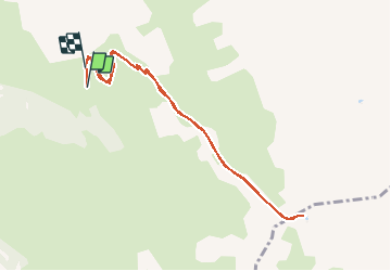
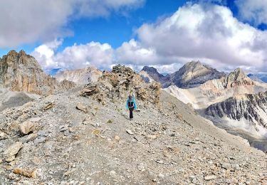
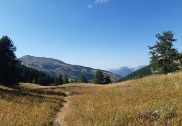
Trail Walking of 9 km to be discovered at Provence-Alpes-Côte d'Azur, Hautes-Alpes, Vars. This trail is proposed by emileverschueren.
Description
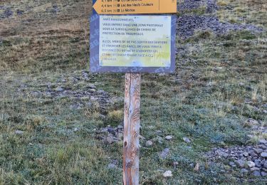
ocalité de départVarsLocalité d'arrivéeVars9.052kmAltitude min.2254mAltitude max.2694mDénivelé Tot. 467mDénivelé Tot. --444mActivitéMarcheDifficultéMoyenneType de solSentierType de parcoursNon officielParcours baliséNonParcours testé par l'auteurNon
Positioning
Country:
France
Region :
Provence-Alpes-Côte d'Azur
Department/Province :
Hautes-Alpes
Municipality :
Vars
Location:
Unknown
Start:(Dec)
Start:(UTM)
319211 ; 4939532 (32T) N.
Comments
Trails nearby
![Trail Walking Vars - Crêtes de Vars - Photo](https://media.geolcdn.com/t/375/260/ext.jpg?maxdim=2&url=https%3A%2F%2Fservices.sitytrail.com%2FGeolivesWS%2FDownloadMedia.ashx%3FTrailID%3D197621%26Media%3D20130611134031.jpeg)
![Walking Walking](https://static1.geolcdn.com/sitytour/trail-icons/101.png)
Crêtes de Vars
Walking
Medium
(2)
Vars,
Provence-Alpes-Côte d'Azur,
Hautes-Alpes,
France
![](/images/other/stat-length.png)
7.7 km | 14.9 km-effort
4h 0min
![](https://static1.geolcdn.com/siteimages/upload/files/16400158638029165_repeat_loop_refresh_sync_direction_icon.png)
Yes
![Trail Walking Vars - 05 Tour Font Sancte - étape 2 - Photo](https://media.geolcdn.com/t/375/260/ext.jpg?maxdim=2&url=https%3A%2F%2Fstatic1.geolcdn.com%2Fsiteimages%2Fupload%2Ffiles%2F1553511878bg_sport_marche.png)
![Walking Walking](https://static1.geolcdn.com/sitytour/trail-icons/101.png)
05 Tour Font Sancte - étape 2
Walking
Very difficult
(1)
Vars,
Provence-Alpes-Côte d'Azur,
Hautes-Alpes,
France
![](/images/other/stat-length.png)
19 km | 38 km-effort
8h 41min
![](https://static1.geolcdn.com/siteimages/upload/files/16400158638029165_repeat_loop_refresh_sync_direction_icon.png)
No
![Trail Other activity Vars - vars 2014 01 11 - Photo](https://media.geolcdn.com/t/375/260/ext.jpg?maxdim=2&url=https%3A%2F%2Fstatic1.geolcdn.com%2Fsiteimages%2Fupload%2Ffiles%2F1545311037marcheuse_200dpi.jpg)
![Other activity Other activity](https://static1.geolcdn.com/sitytour/trail-icons/900.png)
vars 2014 01 11
Other activity
Very easy
(2)
Vars,
Provence-Alpes-Côte d'Azur,
Hautes-Alpes,
France
![](/images/other/stat-length.png)
34 km | 79 km-effort
2h 5min
![](https://static1.geolcdn.com/siteimages/upload/files/16400158638029165_repeat_loop_refresh_sync_direction_icon.png)
No
![Trail Electric bike Vars - Vars - Photo](https://media.geolcdn.com/t/375/260/6a1ee690-ccce-4833-a904-c57c0a1ebcc9.jpg&format=jpg&maxdim=2)
![Electric bike Electric bike](https://static1.geolcdn.com/sitytour/trail-icons/205.png)
Vars
Electric bike
Medium
Vars,
Provence-Alpes-Côte d'Azur,
Hautes-Alpes,
France
![](/images/other/stat-length.png)
34 km | 50 km-effort
2h 59min
![](https://static1.geolcdn.com/siteimages/upload/files/16400158638029165_repeat_loop_refresh_sync_direction_icon.png)
Yes
![Trail Walking Vars - crête des Couniets, lac de l'étoile - Photo](https://media.geolcdn.com/t/375/260/5211d269-d35b-40a4-9ccb-86007299077e.jpg&format=jpg&maxdim=2)
![Walking Walking](https://static1.geolcdn.com/sitytour/trail-icons/101.png)
crête des Couniets, lac de l'étoile
Walking
Medium
Vars,
Provence-Alpes-Côte d'Azur,
Hautes-Alpes,
France
![](/images/other/stat-length.png)
15.6 km | 29 km-effort
7h 32min
![](https://static1.geolcdn.com/siteimages/upload/files/16400158638029165_repeat_loop_refresh_sync_direction_icon.png)
Yes
![Trail Walking Vars - crêtes de Vars - Photo](https://media.geolcdn.com/t/375/260/5761a9bf-3846-455d-a6d4-fd4d19db3ff5.jpg&format=jpg&maxdim=2)
![Walking Walking](https://static1.geolcdn.com/sitytour/trail-icons/101.png)
crêtes de Vars
Walking
Easy
Vars,
Provence-Alpes-Côte d'Azur,
Hautes-Alpes,
France
![](/images/other/stat-length.png)
8.4 km | 16.6 km-effort
4h 30min
![](https://static1.geolcdn.com/siteimages/upload/files/16400158638029165_repeat_loop_refresh_sync_direction_icon.png)
Yes
![Trail Walking Vars - Mortices sud et nord - Photo](https://media.geolcdn.com/t/375/260/d91d83fb-d3c3-4307-b00f-ad598d557e5e.jpg&format=jpg&maxdim=2)
![Walking Walking](https://static1.geolcdn.com/sitytour/trail-icons/101.png)
Mortices sud et nord
Walking
Difficult
Vars,
Provence-Alpes-Côte d'Azur,
Hautes-Alpes,
France
![](/images/other/stat-length.png)
14.6 km | 28 km-effort
10h 34min
![](https://static1.geolcdn.com/siteimages/upload/files/16400158638029165_repeat_loop_refresh_sync_direction_icon.png)
Yes
![Trail Walking Vars - Motrice sud et nord - Photo](https://media.geolcdn.com/t/375/260/60860b12-3e7d-4ab2-b5c5-fe62300095e3.jpg&format=jpg&maxdim=2)
![Walking Walking](https://static1.geolcdn.com/sitytour/trail-icons/101.png)
Motrice sud et nord
Walking
Very difficult
(1)
Vars,
Provence-Alpes-Côte d'Azur,
Hautes-Alpes,
France
![](/images/other/stat-length.png)
14.7 km | 28 km-effort
7h 59min
![](https://static1.geolcdn.com/siteimages/upload/files/16400158638029165_repeat_loop_refresh_sync_direction_icon.png)
Yes
![Trail Walking Vars - col de vars via l écuelle retour via refuge napoléon et font bonne - Photo](https://media.geolcdn.com/t/375/260/0376936b-d693-47b5-85cc-dfd59b78133b.jpg&format=jpg&maxdim=2)
![Walking Walking](https://static1.geolcdn.com/sitytour/trail-icons/101.png)
col de vars via l écuelle retour via refuge napoléon et font bonne
Walking
Medium
Vars,
Provence-Alpes-Côte d'Azur,
Hautes-Alpes,
France
![](/images/other/stat-length.png)
9.9 km | 17 km-effort
5h 8min
![](https://static1.geolcdn.com/siteimages/upload/files/16400158638029165_repeat_loop_refresh_sync_direction_icon.png)
Yes