![](/images/other/stat-length.png)
![Trail Walking Dinant - Balade d'Anseremme à Walzin - Photo](https://media.geolcdn.com/t/1900/400/856a1eef-4c70-4b2c-8033-669caf1c750f.jpeg&format=pjpeg&maxdim=2)
Balade d'Anseremme à Walzin
Desrumaux
User GUIDE
![Length](/images/other/stat-length.png)
Length
9.8 km
![Max alt](https://static1.geolcdn.com/siteimages/upload/files/1508320355ic_sort_altitude_max_24dp.png)
Max alt
231 m
![Uphill gradient](https://static1.geolcdn.com/siteimages/upload/files/1508320355ic_sort_den_pos_24dp.png)
Uphill gradient
267 m
![Km-Effort](/images/other/stat-length.png)
Km-Effort
13.4 km
![Min alt](https://static1.geolcdn.com/siteimages/upload/files/1508320355ic_sort_altitude_min_24dp.png)
Min alt
93 m
![Downhill gradient](https://static1.geolcdn.com/siteimages/upload/files/1508320355ic_sort_den_neg_24dp.png)
Downhill gradient
268 m
![Boucle](https://static1.geolcdn.com/siteimages/upload/files/16400158638029165_repeat_loop_refresh_sync_direction_icon.png)
Boucle
Yes
Creation date :
2022-03-05 08:55:34.485
Updated on :
2022-03-08 08:31:53.633
![Walking](https://static1.geolcdn.com/sitytour/trail-icons/101.png)
4h15
Difficulty : Difficult
![Scan this QR Code to open this trail in the SityTrail application](https://capi.geolives.com/qq0zvz2zws4bq2lad0pu/sitytour/trails/3155530/qr.png?size=200)
FREE GPS app for hiking
About
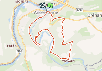
Trail Walking of 9.8 km to be discovered at Wallonia, Namur, Dinant. This trail is proposed by Desrumaux.
Description
Jolie balade un peu sportive au départ de l'église d'Anseremme vers le hameau de Walzin, la balade emprunte quelques sentiers escarpés, éviter les périodes humides.
Positioning
Country:
Belgium
Region :
Wallonia
Department/Province :
Namur
Municipality :
Dinant
Location:
Unknown
Start:(Dec)
Start:(UTM)
636070 ; 5566858 (31U) N.
Comments
Trails nearby
![Walking Walking](https://static1.geolcdn.com/sitytour/trail-icons/101.png)
RB-Na-24-Entre Lesse et Meuse
Walking
Very difficult
(15)
Dinant,
Wallonia,
Namur,
Belgium
![](/images/other/stat-length.png)
19.3 km | 26 km-effort
5h 57min
![](https://static1.geolcdn.com/siteimages/upload/files/16400158638029165_repeat_loop_refresh_sync_direction_icon.png)
Yes
![Trail Walking Houyet - GG-NA-20_Gendron-Celles - Dinant - Photo](https://media.geolcdn.com/t/375/260/ab939ff5-5b33-43fd-b036-e462abc33a68.jpg&format=jpg&maxdim=2)
![Walking Walking](https://static1.geolcdn.com/sitytour/trail-icons/101.png)
GG-NA-20_Gendron-Celles - Dinant
Walking
Very difficult
(6)
Houyet,
Wallonia,
Namur,
Belgium
![](/images/other/stat-length.png)
23 km | 30 km-effort
6h 27min
![](https://static1.geolcdn.com/siteimages/upload/files/16400158638029165_repeat_loop_refresh_sync_direction_icon.png)
No
![Trail Walking Dinant - Balade à Dinant - La Réserve Naturelle de Moniat - Photo](https://media.geolcdn.com/t/375/260/765b9b62-b29c-4537-9ff6-9d29c15be9d8.jpg&format=jpg&maxdim=2)
![Walking Walking](https://static1.geolcdn.com/sitytour/trail-icons/101.png)
Balade à Dinant - La Réserve Naturelle de Moniat
Walking
Very easy
(1)
Dinant,
Wallonia,
Namur,
Belgium
![](/images/other/stat-length.png)
8.4 km | 10.9 km-effort
3h 54min
![](https://static1.geolcdn.com/siteimages/upload/files/16400158638029165_repeat_loop_refresh_sync_direction_icon.png)
Yes
![Trail Walking Dinant - D'Anseremme à Dinant - Photo](https://media.geolcdn.com/t/375/260/ext.jpg?maxdim=2&url=https%3A%2F%2Fservices.sitytrail.com%2FGeolivesWS%2FDownloadMedia.ashx%3FTrailID%3D375788%26Media%3D9ffb86bd-da6e-4936-82b7-07dbdf349394.JPG)
![Walking Walking](https://static1.geolcdn.com/sitytour/trail-icons/101.png)
D'Anseremme à Dinant
Walking
Easy
(3)
Dinant,
Wallonia,
Namur,
Belgium
![](/images/other/stat-length.png)
8.3 km | 11.8 km-effort
2h 34min
![](https://static1.geolcdn.com/siteimages/upload/files/16400158638029165_repeat_loop_refresh_sync_direction_icon.png)
Yes
![Trail Walking Dinant - Balade à Bouvignes - Photo](https://media.geolcdn.com/t/375/260/ext.jpg?maxdim=2&url=https%3A%2F%2Fservices.sitytrail.com%2FGeolivesWS%2FDownloadMedia.ashx%3FTrailID%3D223072%26Media%3D8dae2923-6a84-4680-856b-d65e95092209.JPG)
![Walking Walking](https://static1.geolcdn.com/sitytour/trail-icons/101.png)
Balade à Bouvignes
Walking
Easy
(3)
Dinant,
Wallonia,
Namur,
Belgium
![](/images/other/stat-length.png)
4.8 km | 7.2 km-effort
1h 34min
![](https://static1.geolcdn.com/siteimages/upload/files/16400158638029165_repeat_loop_refresh_sync_direction_icon.png)
Yes
![Trail Walking Dinant - Balade en Réserve Naturelle de Devant Bouvignes - Photo](https://media.geolcdn.com/t/375/260/ext.jpg?maxdim=2&url=https%3A%2F%2Fservices.sitytrail.com%2FGeolivesWS%2FDownloadMedia.ashx%3FTrailID%3D222999%26Media%3D231bd4cd-9ad4-4a88-bcf6-84f0725ce446.JPG)
![Walking Walking](https://static1.geolcdn.com/sitytour/trail-icons/101.png)
Balade en Réserve Naturelle de Devant Bouvignes
Walking
Very easy
(3)
Dinant,
Wallonia,
Namur,
Belgium
![](/images/other/stat-length.png)
4.9 km | 6.9 km-effort
1h 32min
![](https://static1.geolcdn.com/siteimages/upload/files/16400158638029165_repeat_loop_refresh_sync_direction_icon.png)
Yes
![Trail Walking Dinant - Dinant: autour de la Citadelle. - Photo](https://media.geolcdn.com/t/375/260/0debd692-1141-41b3-8018-db8fdb788a39.jpg&format=jpg&maxdim=2)
![Walking Walking](https://static1.geolcdn.com/sitytour/trail-icons/101.png)
Dinant: autour de la Citadelle.
Walking
Easy
(4)
Dinant,
Wallonia,
Namur,
Belgium
![](/images/other/stat-length.png)
5.7 km | 7.5 km-effort
1h 40min
![](https://static1.geolcdn.com/siteimages/upload/files/16400158638029165_repeat_loop_refresh_sync_direction_icon.png)
Yes
![Walking Walking](https://static1.geolcdn.com/sitytour/trail-icons/101.png)
RB-Na-24-racc-Entre Lesse et Meuse
Walking
Very difficult
(4)
Dinant,
Wallonia,
Namur,
Belgium
![](/images/other/stat-length.png)
18.5 km | 24 km-effort
5h 29min
![](https://static1.geolcdn.com/siteimages/upload/files/16400158638029165_repeat_loop_refresh_sync_direction_icon.png)
Yes
![Trail Walking Dinant - DINANT ... Montagne de la Croix et l’ île d'Amour. - Photo](https://media.geolcdn.com/t/375/260/62b66370-733a-438b-8532-4002241cc41c.jpg&format=jpg&maxdim=2)
![Walking Walking](https://static1.geolcdn.com/sitytour/trail-icons/101.png)
DINANT ... Montagne de la Croix et l’ île d'Amour.
Walking
Medium
(1)
Dinant,
Wallonia,
Namur,
Belgium
![](/images/other/stat-length.png)
11.5 km | 15.5 km-effort
3h 13min
![](https://static1.geolcdn.com/siteimages/upload/files/16400158638029165_repeat_loop_refresh_sync_direction_icon.png)
Yes