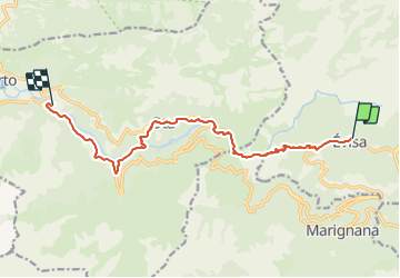
![](/images/other/stat-length.png)
![Trail Walking Évisa - Les gorges de la Spélunca - Photo](https://media.geolcdn.com/t/1900/400/ext.pjpeg?maxdim=2&url=https%3A%2F%2Fstatic1.geolcdn.com%2Fsiteimages%2Fupload%2Ffiles%2F1553511878bg_sport_marche.png)
Les gorges de la Spélunca
Corse 2022
Les amis de Jean Marc
![Length](/images/other/stat-length.png)
Length
13.2 km
![Max alt](https://static1.geolcdn.com/siteimages/upload/files/1508320355ic_sort_altitude_max_24dp.png)
Max alt
861 m
![Uphill gradient](https://static1.geolcdn.com/siteimages/upload/files/1508320355ic_sort_den_pos_24dp.png)
Uphill gradient
228 m
![Km-Effort](/images/other/stat-length.png)
Km-Effort
19 km
![Min alt](https://static1.geolcdn.com/siteimages/upload/files/1508320355ic_sort_altitude_min_24dp.png)
Min alt
23 m
![Downhill gradient](https://static1.geolcdn.com/siteimages/upload/files/1508320355ic_sort_den_neg_24dp.png)
Downhill gradient
1039 m
![Boucle](https://static1.geolcdn.com/siteimages/upload/files/16400158638029165_repeat_loop_refresh_sync_direction_icon.png)
Boucle
No
Creation date :
2022-03-04 17:39:48.998
Updated on :
2022-03-14 13:53:44.358
![Walking](https://static1.geolcdn.com/sitytour/trail-icons/101.png)
4h18
Difficulty : Difficult
![Scan this QR Code to open this trail in the SityTrail application](https://capi.geolives.com/qq0zvz2zws4bq2lad0pu/sitytour/trails/3154879/qr.png?size=200)
FREE GPS app for hiking
About
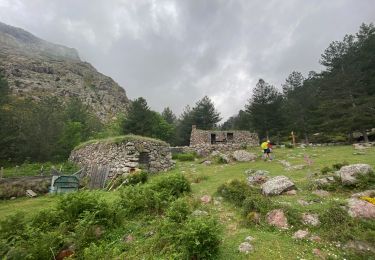
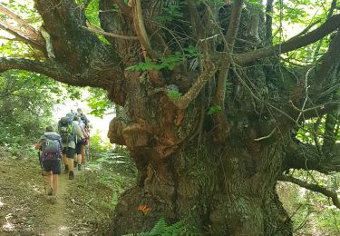
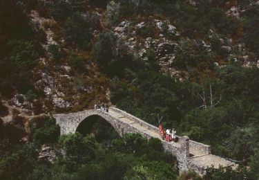
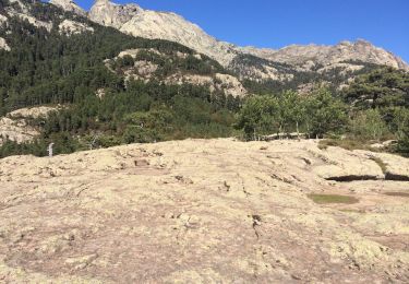
Trail Walking of 13.2 km to be discovered at Corsica, South Corsica, Évisa. This trail is proposed by Corse 2022.
Description
Rando tout en dénivelé négatif, plus de1000m
Départ d'Evisa et lieu précis à déterminer
Positioning
Country:
France
Region :
Corsica
Department/Province :
South Corsica
Municipality :
Évisa
Location:
Unknown
Start:(Dec)
Start:(UTM)
483831 ; 4678019 (32T) N.
Comments
Trails nearby
![Trail Walking Ota - Gorge de spelunca - Photo](https://media.geolcdn.com/t/375/260/f6804445-15a3-4e4f-812b-febb15caa6ee.jpg&format=jpg&maxdim=2)
![Walking Walking](https://static1.geolcdn.com/sitytour/trail-icons/101.png)
![Trail Walking Ota - gorges de la spelunca et pont, ota, corse - Photo](https://media.geolcdn.com/t/375/260/ext.jpg?maxdim=2&url=https%3A%2F%2Fservices.sitytrail.com%2FGeolivesWS%2FDownloadMedia.ashx%3FTrailID%3D209384%26Media%3D20130801094128.jpg)
![Walking Walking](https://static1.geolcdn.com/sitytour/trail-icons/101.png)
gorges de la spelunca et pont, ota, corse
Walking
Easy
(1)
Ota,
Corsica,
South Corsica,
France
![](/images/other/stat-length.png)
2.9 km | 4.5 km-effort
58min
![](https://static1.geolcdn.com/siteimages/upload/files/16400158638029165_repeat_loop_refresh_sync_direction_icon.png)
No
![Trail Walking Évisa - Corse 2023: Evisa - Refuge de Puscaghia - Photo](https://media.geolcdn.com/t/375/260/fb30a792-f923-4082-8f8f-351b3293aa77.jpeg&format=jpg&maxdim=2)
![Walking Walking](https://static1.geolcdn.com/sitytour/trail-icons/101.png)
Corse 2023: Evisa - Refuge de Puscaghia
Walking
Difficult
Évisa,
Corsica,
South Corsica,
France
![](/images/other/stat-length.png)
16.6 km | 29 km-effort
6h 35min
![](https://static1.geolcdn.com/siteimages/upload/files/16400158638029165_repeat_loop_refresh_sync_direction_icon.png)
No
![Trail Walking Ota - Ota Mariniana - Photo](https://media.geolcdn.com/t/375/260/b92651dc-1968-4d40-9564-f6b44744830a.jpg&format=jpg&maxdim=2)
![Walking Walking](https://static1.geolcdn.com/sitytour/trail-icons/101.png)
![Trail On foot Ota - Ota canyons - Photo](https://media.geolcdn.com/t/375/260/4dad7e61-defe-4494-9d4b-3248fec98a02.jpeg&format=jpg&maxdim=2)
![On foot On foot](https://static1.geolcdn.com/sitytour/trail-icons/100.png)
![Trail Walking Évisa - Evisa forêt d’aitone - Photo](https://media.geolcdn.com/t/375/260/08798ad8-3986-4664-8380-dace3a816c80.jpg&format=jpg&maxdim=2)
![Walking Walking](https://static1.geolcdn.com/sitytour/trail-icons/101.png)
Evisa forêt d’aitone
Walking
Easy
Évisa,
Corsica,
South Corsica,
France
![](/images/other/stat-length.png)
13.4 km | 19.7 km-effort
4h 11min
![](https://static1.geolcdn.com/siteimages/upload/files/16400158638029165_repeat_loop_refresh_sync_direction_icon.png)
Yes
![Trail Walking Évisa - gorges spelunca - Photo](https://media.geolcdn.com/t/375/260/2ba82175-16ea-471a-af7d-9a429f43496d.jpg&format=jpg&maxdim=2)
![Walking Walking](https://static1.geolcdn.com/sitytour/trail-icons/101.png)
gorges spelunca
Walking
Easy
Évisa,
Corsica,
South Corsica,
France
![](/images/other/stat-length.png)
4.7 km | 7.5 km-effort
1h 46min
![](https://static1.geolcdn.com/siteimages/upload/files/16400158638029165_repeat_loop_refresh_sync_direction_icon.png)
No
![Trail Walking Ota - Corse 2018 sentier des gorges - Photo](https://media.geolcdn.com/t/375/260/ext.jpg?maxdim=2&url=https%3A%2F%2Fservices.sitytrail.com%2FGeolivesWS%2FDownloadMedia.ashx%3FTrailID%3D948615%26Media%3Dfix__20180421184451.jpg)
![Walking Walking](https://static1.geolcdn.com/sitytour/trail-icons/101.png)
Corse 2018 sentier des gorges
Walking
Easy
Ota,
Corsica,
South Corsica,
France
![](/images/other/stat-length.png)
14.5 km | 25 km-effort
4h 27min
![](https://static1.geolcdn.com/siteimages/upload/files/16400158638029165_repeat_loop_refresh_sync_direction_icon.png)
Yes
![Trail Walking Ota - Ota - Barghiana - Photo](https://media.geolcdn.com/t/375/260/ext.jpg?maxdim=2&url=https%3A%2F%2Fservices.sitytrail.com%2FGeolivesWS%2FDownloadMedia.ashx%3FTrailID%3D118841%26Media%3D13057_6.jpg)
![Walking Walking](https://static1.geolcdn.com/sitytour/trail-icons/101.png)
Ota - Barghiana
Walking
Very difficult
Ota,
Corsica,
South Corsica,
France
![](/images/other/stat-length.png)
49 km | 94 km-effort
30h 0min
![](https://static1.geolcdn.com/siteimages/upload/files/16400158638029165_repeat_loop_refresh_sync_direction_icon.png)
No