Trail On foot Couthenans - Départ COUTHENANS ParkPierrette-Luze-Chagey-mini tour eiffel-H.Valettes-Etang réchal-Park Arrivée - Photo

Départ COUTHENANS ParkPierrette-Luze-Chagey-mini tour eiffel-H.Valettes-Etang réchal-Park Arrivée

 SOYARD
SOYARD

User

© OpenStreetMap contributors
Length
Length
12.1 km
Max alt
Max alt
455 m
Uphill gradient
Uphill gradient
255 m
Km-Effort
Km-Effort  
15.5 km
Min alt
Min alt
349 m
Downhill gradient
Downhill gradient
249 m
Boucle
Boucle
Yes
Creation date :
2022-03-04 09:08:13.507
Updated on :
2022-03-04 09:23:38.205

(0 Reviews)

On foot
On foot
3h31
Difficulty : Easy

Scan this QR Code to open this trail in the SityTrail application

FREE GPS app for hiking

Logo SityTrail SityTrail

IGN / Geographical institutes

Download SityTrail from the App Store Download SityTrail from Google Play

Logo SityTrail SityTrail World

The world is yours!

Download SityTrail from the App Store Download SityTrail from Google Play Download SityTrail on Huawei AppGallery

About

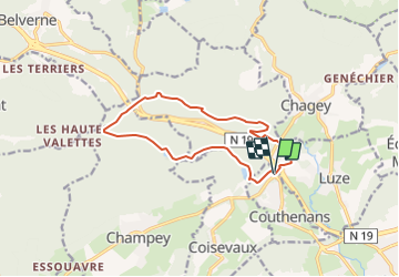
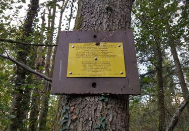
Trail On foot of 12.1 km to be discovered at Bourgogne-Franche-Comté, Haute-Saône, Couthenans. This trail is proposed by SOYARD.

Description

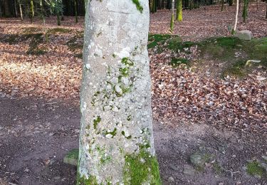
Randonnée 12 km,dénivelé 260  de difficultée moyenne : Départ du parking des bois de Vaux (face Pierrette): première partie de 5 km par sentiers, avec petites côtes . Ensuite chemin . Pause à 7,5 km au pied "mini tour Eiffel" (relais telph). Puis 800 m route des Htes Valettes à circulation réduite. Chemin vers étant Réchal et retour parking.

Elevation profile

Positioning

Country:
France
Region :
Bourgogne-Franche-Comté
Department/Province :
Haute-Saône
Municipality :
Couthenans
Location:
Unknown
Start:(UTM)
328801 ; 5274119 (32T) N.

Trails nearby

Trail Walking Héricourt - La Pierre Plate - Héricourt - Photo
Walking
tracegps

Walking

Difficult
(3)
Héricourt, Bourgogne-Franche-Comté, Haute-Saône, France
12 km | 16.4 km-effort
3h 10min
Yes
Trail Walking Trémoins - TREMOINS - Photo
Walking
Marchebuissonniere

Walking

Medium
(1)
Trémoins, Bourgogne-Franche-Comté, Haute-Saône, France
8.3 km | 10.5 km-effort
3h 22min
Yes
Trail Walking Champey - champey - Photo
Walking
Fillatre

Walking

Difficult
(1)
Champey, Bourgogne-Franche-Comté, Haute-Saône, France
12.6 km | 16.5 km-effort
3h 37min
Yes
Trail Electric bike Châlonvillars - VTT - Châlonvillars - Etobon - Ronchamp - Plancher-Bas - Malsaucy - Photo
Electric bike
Bart2015

Electric bike

Difficult
Châlonvillars, Bourgogne-Franche-Comté, Haute-Saône, France
71 km | 90 km-effort
5h 50min
Yes
Trail Walking Mandrevillars - Echenans et son fort - Photo
Walking
Bart2015

Walking

Very difficult
Mandrevillars, Bourgogne-Franche-Comté, Haute-Saône, France
14.8 km | 19.6 km-effort
4h 27min
Yes
Trail Mountain bike Châlonvillars - Châlonvillars - Fort Giromagny en passant au milieu des étangs - Photo
Mountain bike
Bart2015

Mountain bike

Very difficult
Châlonvillars, Bourgogne-Franche-Comté, Haute-Saône, France
40 km | 51 km-effort
3h 31min
Yes
Trail Mountain bike Châlonvillars - Châlonvillars - Menhir - Mandrevillars - Fort Essert et du Salbert - Photo
Mountain bike
Bart2015

Mountain bike

Very difficult
Châlonvillars, Bourgogne-Franche-Comté, Haute-Saône, France
31 km | 42 km-effort
2h 53min
Yes
Trail Walking Châlonvillars - Châlonvillars - le mehnir - Mandrevillars - Photo
Walking
Bart2015

Walking

Medium
Châlonvillars, Bourgogne-Franche-Comté, Haute-Saône, France
13.4 km | 17.1 km-effort
2h 39min
Yes
Trail Walking Châlonvillars - Châlonvillars - Mandrevillars - Photo
Walking
Bart2015

Walking

Easy
Châlonvillars, Bourgogne-Franche-Comté, Haute-Saône, France
9.5 km | 11.9 km-effort
1h 33min
Yes


Close
My subscriptions