Trail Snowshoes Villard-de-Lans - Lac de la Moucherolle - Photo
 phidge
phidge

User

© OpenStreetMap contributors
Length
Length
11.5 km
Max alt
Max alt
2021 m
Uphill gradient
Uphill gradient
421 m
Km-Effort
Km-Effort  
19.1 km
Min alt
Min alt
1150 m
Downhill gradient
Downhill gradient
994 m
Boucle
Boucle
No
Creation date :
2022-03-03 21:56:38.307
Updated on :
2022-03-04 13:42:30.166

(0 Reviews)

Snowshoes
Snowshoes
0m
Difficulty : Very easy

Scan this QR Code to open this trail in the SityTrail application

FREE GPS app for hiking

Logo SityTrail SityTrail

IGN / Geographical institutes

Download SityTrail from the App Store Download SityTrail from Google Play

Logo SityTrail SityTrail World

The world is yours!

Download SityTrail from the App Store Download SityTrail from Google Play Download SityTrail on Huawei AppGallery

About

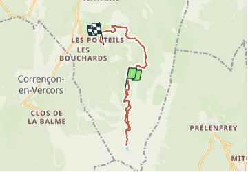
Trail Snowshoes of 11.5 km to be discovered at Auvergne-Rhône-Alpes, Isère, Villard-de-Lans. This trail is proposed by phidge.

Description

Description de la randonnée

Pour rejoindre le départ de la randonnée, stationner sur le parking du Balcon de Villard et prendre le télécabine de la "côte 2000" dont l'altitude d'arrivée est à 1720m (fonctionne l'été à partir du mois de Juin).

(D) À la gare d'arrivée, emprunter le chemin sur la gauche qui monte.
Après être passé trois fois sous la remontée mécanique, rejoindre un large virage à droite.

(1) Prendre le sentier qui part sur la gauche (présence de panneaux : Lac de la Moucherolle par les rochers de Jaux, balisage Jaune et Vert). Deux ou trois passages sont assez vertigineux mais ne présentent aucune difficulté. Remarque : ce sentier ne figure pas en totalité sur les cartes. Retrouver sous les Rochers des Jaux.

Elevation profile

Points of interest

Point of interest Villard-de-Lans - Parking au départ des télécabines - Photo
phidge
Point of interest Villard-de-Lans - Les Glovettes - Photo
phidge
VILLARD-DE-LANS 
Point of interest Villard-de-Lans - Direction les Glovettes - Photo
phidge
VILLARD-DE-LANS 
Point of interest Villard-de-Lans - Obliquer à gauche dans le sentier dans la forêt - Photo
phidge
Point of interest Villard-de-Lans - A 100m à gauche - Photo
phidge
VILLARD-DE-LANS 
Point of interest Villard-de-Lans - Au fond du vallon partir par la gauche - Photo
phidge
Point of interest Villard-de-Lans - Départ du chemin pas bien visible - Photo
phidge
Point of interest Villard-de-Lans - Passer par les pistes de ski, hors sentiers - Photo
phidge
Point of interest Villard-de-Lans - Le lac - Photo
phidge
VILLARD-DE-LANS 
Point of interest Villard-de-Lans - Suivre la piste qui contourne la cabane - Photo
phidge
Point of interest Villard-de-Lans - Bien suivre le balisage (trace de droite) - Photo
phidge
Point of interest Villard-de-Lans - À gauche par les rochers des Jaux - Photo
phidge
Point of interest Villard-de-Lans - Départ en haut des télécabines de la "côte 2000" - Photo
phidge

Positioning

Country:
France
Region :
Auvergne-Rhône-Alpes
Department/Province :
Isère
Municipality :
Villard-de-Lans
Location:
Unknown
Start:(UTM)
702418 ; 4989473 (31T) N.

Trails nearby

Trail Walking Villard-de-Lans - villard col des 2 soeurs - Photo
Walking
arnaudconde

Walking

Medium
(1)
Villard-de-Lans, Auvergne-Rhône-Alpes, Isère, France
7.7 km | 13.8 km-effort
2h 45min
Yes
Trail Walking Villard-de-Lans - cabane de robon - Photo
Walking
Sylvie Mathiot

Walking

Very easy
(1)
Villard-de-Lans, Auvergne-Rhône-Alpes, Isère, France
10.2 km | 15.8 km-effort
5h 25min
Yes
Trail Walking Château-Bernard - la soldanelle - Photo
Walking
cmarit

Walking

Easy
(1)
Château-Bernard, Auvergne-Rhône-Alpes, Isère, France
6.1 km | 10.8 km-effort
3h 17min
No
Trail Mountain bike Corrençon-en-Vercors - Grande Traversée des PréAlpes à VTT : Corrençon en Vercors - La Chapelle en Vercors - Photo
Mountain bike
tracegps

Mountain bike

Difficult
(1)
Corrençon-en-Vercors, Auvergne-Rhône-Alpes, Isère, France
25 km | 36 km-effort
3h 30min
No
Trail Walking Villard-de-Lans - Le sentier Peronnard et le Pas de l'OEille - Photo
Walking
tracegps

Walking

Easy
(1)
Villard-de-Lans, Auvergne-Rhône-Alpes, Isère, France
13.7 km | 25 km-effort
6h 0min
Yes
Trail Walking Villard-de-Lans - Le Plateau du Cornafion 1906m - Photo
Walking
tracegps

Walking

Difficult
(1)
Villard-de-Lans, Auvergne-Rhône-Alpes, Isère, France
7.8 km | 17.7 km-effort
4h 30min
Yes
Trail Mountain bike Villard-de-Lans - Villars de Lans Vières Les Cochettes Balcon de Villard Clot de la Balme Correncon - Photo
Mountain bike
GrouGary

Mountain bike

Medium
(1)
Villard-de-Lans, Auvergne-Rhône-Alpes, Isère, France
22 km | 32 km-effort
3h 31min
Yes
Trail Walking Villard-de-Lans - col_vert - Photo
Walking
vrolanta

Walking

Medium
(2)
Villard-de-Lans, Auvergne-Rhône-Alpes, Isère, France
8.7 km | 16.4 km-effort
3h 0min
Yes
Trail Mountain bike Villard-de-Lans - La Royale (variante) - Photo
Mountain bike
flyingdad

Mountain bike

Medium
(1)
Villard-de-Lans, Auvergne-Rhône-Alpes, Isère, France
28 km | 37 km-effort
4h 0min
Yes


Close
My subscriptions