Trail Nordic walking La Celle-Saint-Cloud - Bougival -> L’Étang-la-Ville - Photo

Bougival -> L’Étang-la-Ville

 Misti83
Misti83

User

© OpenStreetMap contributors
Length
Length
12.9 km
Max alt
Max alt
188 m
Uphill gradient
Uphill gradient
254 m
Km-Effort
Km-Effort  
16.3 km
Min alt
Min alt
74 m
Downhill gradient
Downhill gradient
257 m
Boucle
Boucle
No
Creation date :
2022-03-03 07:55:12.0
Updated on :
2022-03-03 10:45:08.169

(0 Reviews)

Nordic walking
Nordic walking
2h48
Difficulty : Unknown

Scan this QR Code to open this trail in the SityTrail application

FREE GPS app for hiking

Logo SityTrail SityTrail

IGN / Geographical institutes

Download SityTrail from the App Store Download SityTrail from Google Play

Logo SityTrail SityTrail World

The world is yours!

Download SityTrail from the App Store Download SityTrail from Google Play Download SityTrail on Huawei AppGallery

About

Trail Nordic walking of 12.9 km to be discovered at Ile-de-France, Yvelines, La Celle-Saint-Cloud. This trail is proposed by Misti83.

Elevation profile

Positioning

Country:
France
Region :
Ile-de-France
Department/Province :
Yvelines
Municipality :
La Celle-Saint-Cloud
Location:
Unknown
Start:(Dec)
Start:(UTM)
436335 ; 5411610 (31U) N.

Trails nearby

Trail Walking Rueil-Malmaison - St Germain en Laye - Rueil Malmaison 28 km Inversee - Photo
Walking
GUIDE
chessyca

Walking

Easy
(1)
Rueil-Malmaison, Ile-de-France, Hauts-de-Seine, France
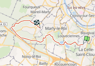
28 km | 32 km-effort
6h 0min
No
Trail Walking Chaville - GRP CV-IDF 20R Chaville à Vaucresson - Photo
Walking
clalaur

Walking

Medium
(1)
Chaville, Ile-de-France, Hauts-de-Seine, France
8.2 km | 11.1 km-effort
2h 30min
No
Trail Walking Bougival - Bougival-Saint-cucufa reel - Photo
Walking
perlimpinpin59

Walking

(1)
Bougival, Ile-de-France, Yvelines, France
7.7 km | 10.3 km-effort
2h 29min
Yes
Trail Walking Marly-le-Roi - Boucle 25 km Marly le Roi - Chambourcy - Photo
Walking
GUIDE
chessyca

Walking

Medium
Marly-le-Roi, Ile-de-France, Yvelines, France
25 km | 32 km-effort
7h 15min
Yes
Trail On foot Rueil-Malmaison - SityTrail - 3850997 - rando-chatou (1) - Photo
On foot
GUIDE
chessyca

On foot

Medium
Rueil-Malmaison, Ile-de-France, Hauts-de-Seine, France
32 km | 37 km-effort
8h 22min
No
Trail Walking Saint-Germain-en-Laye - Audax St Germain en Laye - Paris Tour Eiffel - Photo
Walking
GUIDE
chessyca

Walking

Easy
Saint-Germain-en-Laye, Ile-de-France, Yvelines, France
29 km | 35 km-effort
4h 59min
No
Trail On foot Versailles - Boucle 28 km autour de Versailles - Photo
On foot
GUIDE
chessyca

On foot

Medium
Versailles, Ile-de-France, Yvelines, France
28 km | 33 km-effort
7h 25min
Yes
Trail Walking Rueil-Malmaison - De Rueil Malmaison aux Serres d'Auteuil via Suresnes - Photo
Walking
GUIDE
chessyca

Walking

Very easy
Rueil-Malmaison, Ile-de-France, Hauts-de-Seine, France
22 km | 26 km-effort
5h 3min
No
Trail Walking Rueil-Malmaison - Domaine Malmaison - Cité jardin Suresnes - Boulogne - Serres d'Auteuil - Photo
Walking
GUIDE
chessyca

Walking

Easy
Rueil-Malmaison, Ile-de-France, Hauts-de-Seine, France
22 km | 27 km-effort
4h 54min
No


Close
My subscriptions