Trail On foot Zalaegerszeg - Horhosok útja (kék) - Photo

Horhosok útja (kék)

Tous les sentiers balisés d’Europe PRO

© OpenStreetMap contributors
Length
Length
12.8 km
Max alt
Max alt
267 m
Uphill gradient
Uphill gradient
304 m
Km-Effort
Km-Effort  
16.9 km
Min alt
Min alt
140 m
Downhill gradient
Downhill gradient
302 m
Boucle
Boucle
Yes
Signpost
Signpost
Creation date :
2022-02-21 11:29:23.654
Updated on :
2022-03-09 04:15:53.183

(0 Reviews)

On foot
On foot
3h50
Difficulty : Easy

Scan this QR Code to open this trail in the SityTrail application

FREE GPS app for hiking

Logo SityTrail SityTrail

IGN / Geographical institutes

Download SityTrail from the App Store Download SityTrail from Google Play

Logo SityTrail SityTrail World

The world is yours!

Download SityTrail from the App Store Download SityTrail from Google Play Download SityTrail on Huawei AppGallery

About

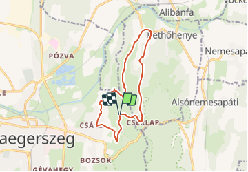
Trail On foot of 12.8 km to be discovered at Transdanubia, Zala, Zalaegerszeg. This trail is proposed by SityTrail - itinéraires balisés pédestres.

Description

Zalaegerszeg város hivatalos turisztikai honlapja

Website: https://zalaegerszegturizmus.hu/info/latnivalok/turautvonalak/

Positioning

Country:
Hungary
Region :
Transdanubia
Department/Province :
Zala
Municipality :
Zalaegerszeg
Location:
Unknown
Start:(UTM)
644298 ; 5190192 (33T) N.

Trails nearby

Trail On foot Zalaegerszeg - Horhosok útja (piros) - Photo
On foot
PRO

On foot

Medium
Zalaegerszeg, Transdanubia, Zala, Hungary
21 km | 27 km-effort
6h 12min
Yes
Trail On foot Zalaegerszeg - Horhosok útja (zöld) - Photo
On foot
PRO

On foot

Easy
Zalaegerszeg, Transdanubia, Zala, Hungary
8.1 km | 11.1 km-effort
2h 30min
Yes


Close
My subscriptions