


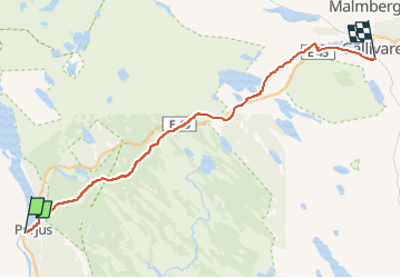
Rallarstigen

SityTrail - itinéraires balisés pédestres
Tous les sentiers balisés d’Europe GUIDE+

Length
50 km

Max alt
544 m

Uphill gradient
629 m
Km-Effort
58 km

Min alt
344 m

Downhill gradient
611 m
Boucle
No

Signpost
Creation date :
2022-02-21 11:20:53.189
Updated on :
2022-03-09 03:19:34.241
13h12
Difficulty : Very difficult

FREE GPS app for hiking
 SityTrail
IGN / Geographical institutes
SityTrail World
The world is yours!
About
Trail On foot of 50 km to be discovered at Norrbotten County. This trail is proposed by SityTrail - itinéraires balisés pédestres.
Description
Website: http://www.laponia.info/landskapet/platser/muddus-rallarstigen/
Photos


Positioning
Country:
Sweden
Region :
Norrbotten County
Department/Province :
Unknown
Municipality :
Unknown
Location:
Unknown
Start:(Dec)
Start:(UTM)
447612 ; 7427136 (34W) N.
Comments
Trails nearby