Trail On foot Anundsjö District - Kunnådalens vandringsled - Photo

Tous les sentiers balisés d’Europe GUIDE+

© OpenStreetMap contributors
Length
Length
4.8 km
Max alt
Max alt
301 m
Uphill gradient
Uphill gradient
52 m
Km-Effort
Km-Effort  
5.5 km
Min alt
Min alt
266 m
Downhill gradient
Downhill gradient
61 m
Boucle
Boucle
No
Signpost
Signpost
Creation date :
2022-02-21 11:19:27.292
Updated on :
2022-03-09 03:10:44.002

(0 Reviews)

On foot
On foot
1h15
Difficulty : Easy

Scan this QR Code to open this trail in the SityTrail application

FREE GPS app for hiking

Logo SityTrail SityTrail

IGN / Geographical institutes

Download SityTrail from the App Store Download SityTrail from Google Play

Logo SityTrail SityTrail World

The world is yours!

Download SityTrail from the App Store Download SityTrail from Google Play Download SityTrail on Huawei AppGallery

About

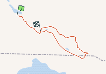
Trail On foot of 4.8 km to be discovered at Västernorrland County, Unknown, Anundsjö District. This trail is proposed by SityTrail - itinéraires balisés pédestres.

Description

Utanför Örnsköldsvik ligger Kunnådalens Kunskapsskog. Ett område på drygt 2 500 hektar. Här är temat vildmark och kulturhistoria i samspel med ett hållbart skogsbruk.

Website: https://www.holmen.com/sv/skog/besok-skogen/kunskapsskogar/kunnadalen/

Elevation profile

Positioning

Country:
Sweden
Region :
Västernorrland County
Department/Province :
Unknown
Municipality :
Anundsjö District
Location:
Unknown
Start:(UTM)
625105 ; 7041518 (33V) N.

Trails nearby


Close
My subscriptions