![](/images/other/stat-length.png)
![Trail On foot Unknown - Eriksleden - Photo](https://media.geolcdn.com/t/1900/400/c1bcbeae-a521-4c53-83f7-16dbccabe4a3.jpeg&format=pjpeg&maxdim=2)
Eriksleden
SityTrail - itinéraires balisés pédestres
Tous les sentiers balisés d’Europe GUIDE+
![Length](/images/other/stat-length.png)
Length
6 km
![Max alt](https://static1.geolcdn.com/siteimages/upload/files/1508320355ic_sort_altitude_max_24dp.png)
Max alt
43 m
![Uphill gradient](https://static1.geolcdn.com/siteimages/upload/files/1508320355ic_sort_den_pos_24dp.png)
Uphill gradient
67 m
![Km-Effort](/images/other/stat-length.png)
Km-Effort
6.8 km
![Min alt](https://static1.geolcdn.com/siteimages/upload/files/1508320355ic_sort_altitude_min_24dp.png)
Min alt
11 m
![Downhill gradient](https://static1.geolcdn.com/siteimages/upload/files/1508320355ic_sort_den_neg_24dp.png)
Downhill gradient
48 m
![Boucle](https://static1.geolcdn.com/siteimages/upload/files/16400158638029165_repeat_loop_refresh_sync_direction_icon.png)
Boucle
No
Signpost
Creation date :
2022-02-21 11:14:59.467
Updated on :
2022-03-09 02:51:08.883
![On foot](https://static1.geolcdn.com/sitytour/trail-icons/100.png)
1h33
Difficulty : Easy
![Scan this QR Code to open this trail in the SityTrail application](https://capi.geolives.com/qq0zvz2zws4bq2lad0pu/sitytour/trails/3140591/qr.png?size=200)
FREE GPS app for hiking
About
Trail On foot of 6 km to be discovered at Uppsala County. This trail is proposed by SityTrail - itinéraires balisés pédestres.
Description
En vandring där nutid möter forntid och stad möter land. Vandra mellan Uppsala domkyrka till den gamla domkyrkan i Gamla Uppsala.
Website: https://www.svenskakyrkan.se/uppsala/eriksleden
Positioning
Country:
Sweden
Region :
Uppsala County
Department/Province :
Unknown
Municipality :
Unknown
Location:
Unknown
Start:(Dec)
Start:(UTM)
647505 ; 6638577 (33V) N.
Comments
Trails nearby
![Trail On foot - Linnéstig - Gamla uppsalavandringen - Photo](https://media.geolcdn.com/t/375/260/b9a7077a-2423-439e-a2e2-b975bb0533fa.jpeg&format=jpg&maxdim=2)
![On foot On foot](https://static1.geolcdn.com/sitytour/trail-icons/100.png)
Linnéstig - Gamla uppsalavandringen
On foot
Easy
,
Uppsala County,
,
Sweden
![](/images/other/stat-length.png)
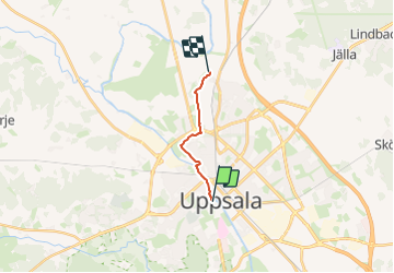
4.9 km | 5.5 km-effort
1h 14min
![](https://static1.geolcdn.com/siteimages/upload/files/16400158638029165_repeat_loop_refresh_sync_direction_icon.png)
No
![Trail On foot - Gula stigen - Photo](https://media.geolcdn.com/t/375/260/f67787b2-3259-435b-afe5-b8d433b89911.jpeg&format=jpg&maxdim=2)
![On foot On foot](https://static1.geolcdn.com/sitytour/trail-icons/100.png)
![Trail Walking - Uppsala - Gamla Uppsala - chemin des pèlerins - Photo](https://media.geolcdn.com/t/375/260/35971375-51cf-4f70-b8be-9a5c5e0572dc.jpg&format=jpg&maxdim=2)
![Walking Walking](https://static1.geolcdn.com/sitytour/trail-icons/101.png)
Uppsala - Gamla Uppsala - chemin des pèlerins
Walking
Medium
,
Uppsala County,
,
Sweden
![](/images/other/stat-length.png)
7.2 km | 8.2 km-effort
1h 14min
![](https://static1.geolcdn.com/siteimages/upload/files/16400158638029165_repeat_loop_refresh_sync_direction_icon.png)
No
![Trail On foot - Linnéstigarna Danmarksvandringen - Photo](https://media.geolcdn.com/t/375/260/6ac1496f-72fc-40e2-b3e0-b99e4e75efca.jpeg&format=jpg&maxdim=2)
![On foot On foot](https://static1.geolcdn.com/sitytour/trail-icons/100.png)
Linnéstigarna Danmarksvandringen
On foot
Easy
,
Uppsala County,
,
Sweden
![](/images/other/stat-length.png)
5.3 km | 5.7 km-effort
1h 17min
![](https://static1.geolcdn.com/siteimages/upload/files/16400158638029165_repeat_loop_refresh_sync_direction_icon.png)
No