Trail On foot Unknown - Mäselnleden - Photo

Tous les sentiers balisés d’Europe GUIDE+

© OpenStreetMap contributors
Length
Length
6.2 km
Max alt
Max alt
64 m
Uphill gradient
Uphill gradient
59 m
Km-Effort
Km-Effort  
6.9 km
Min alt
Min alt
40 m
Downhill gradient
Downhill gradient
59 m
Boucle
Boucle
Yes
Signpost
Signpost
Creation date :
2022-02-21 11:07:10.776
Updated on :
2022-03-09 02:04:36.153

(0 Reviews)

On foot
On foot
1h34
Difficulty : Easy

Scan this QR Code to open this trail in the SityTrail application

FREE GPS app for hiking

Logo SityTrail SityTrail

IGN / Geographical institutes

Download SityTrail from the App Store Download SityTrail from Google Play

Logo SityTrail SityTrail World

The world is yours!

Download SityTrail from the App Store Download SityTrail from Google Play Download SityTrail on Huawei AppGallery

About

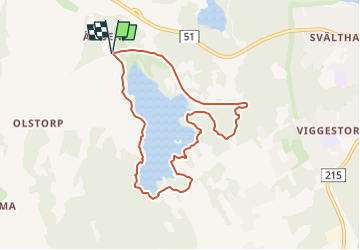
Trail On foot of 6.2 km to be discovered at Östergötland County. This trail is proposed by SityTrail - itinéraires balisés pédestres.

Description

Symbol: Orange paint on trees and signs

Elevation profile

Positioning

Country:
Sweden
Region :
Östergötland County
Department/Province :
Unknown
Municipality :
Unknown
Location:
Unknown
Start:(UTM)
541221 ; 6507781 (33V) N.

Comments

Please log in to post a review or rate the element


Mooie wandeling, grotendeels makkelijk, maar ook enkele stukken die iets lastiger zijn - maar goed te doen. Het deel langs een onverhard fietspad is iets minder interessant, maar de tocht is echt de moeite waard. De route is goed aangegeven, op een enkele kruising na, dus gebruik van gps als noodhulp is aan te raden. Begin- en eindpunt staan op het kaartje niet juist aangegeven.


Trails nearby

Trail On foot  - Gruvleden - Photo
On foot
GUIDE+

On foot

Easy
, Östergötland County, , Sweden
7.8 km | 8.7 km-effort
1h 57min
No
Trail On foot Unknown - Rådslaleden - Photo
On foot
GUIDE+

On foot

Easy
Unknown, Östergötland County, Unknown, Sweden
3.9 km | 4.5 km-effort
1h 0min
No


Close
My subscriptions