


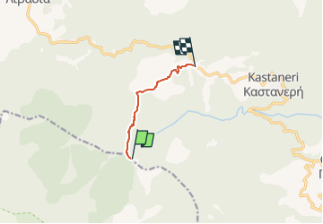
Παλιοχώρι - Γκόλα Τσούκα

SityTrail - itinéraires balisés pédestres
Tous les sentiers balisés d’Europe GUIDE+

Length
5 km

Max alt
1558 m

Uphill gradient
16 m
Km-Effort
6.7 km

Min alt
1121 m

Downhill gradient
449 m
Boucle
No

Signpost
Creation date :
2022-02-21 11:01:08.257
Updated on :
2022-03-09 01:21:17.019
1h31
Difficulty : Easy

FREE GPS app for hiking
 SityTrail
IGN / Geographical institutes
SityTrail World
The world is yours!
About
Trail On foot of 5 km to be discovered at Macedonia and Thrace, Pella Regional Unit. This trail is proposed by SityTrail - itinéraires balisés pédestres.
Photos

Positioning
Country:
Greece
Region :
Macedonia and Thrace
Department/Province :
Pella Regional Unit
Municipality :
Unknown
Location:
Unknown
Start:(Dec)
Start:(UTM)
612111 ; 4534814 (34T) N.
Comments
Trails nearby