Trail Walking Les Houches - TMB - Complet (9 jours) - Photo
 Fab-Oz
Fab-Oz

User

© OpenStreetMap contributors
Length
Length
156 km
Max alt
Max alt
2668 m
Uphill gradient
Uphill gradient
11278 m
Km-Effort
Km-Effort  
306 km
Min alt
Min alt
975 m
Downhill gradient
Downhill gradient
11279 m
Boucle
Boucle
Yes
Creation date :
2019-05-10 09:09:38.594
Updated on :
2019-05-10 09:09:40.892

(0 Reviews)

Walking
Walking
24h44
Difficulty : Very difficult

Scan this QR Code to open this trail in the SityTrail application

FREE GPS app for hiking

Logo SityTrail SityTrail

IGN / Geographical institutes

Download SityTrail from the App Store Download SityTrail from Google Play

Logo SityTrail SityTrail World

The world is yours!

Download SityTrail from the App Store Download SityTrail from Google Play Download SityTrail on Huawei AppGallery

About

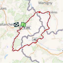
Trail Walking of 156 km to be discovered at Auvergne-Rhône-Alpes, Upper Savoy, Les Houches. This trail is proposed by Fab-Oz.

Description

Tour du Mont Blanc complet en 9 jours
Départ Les Houches (avec montée au Col de la Voza en plus à pieds 2h30 ou en télécabines 15 min)

Elevation profile

Positioning

Country:
France
Region :
Auvergne-Rhône-Alpes
Department/Province :
Upper Savoy
Municipality :
Les Houches
Location:
Unknown
Start:(UTM)
328478 ; 5084161 (32T) N.

Comments

Please log in to post a review or rate the element


Trails nearby

Trail Walking Chamonix-Mont-Blanc - J8 - Cascade du Dard - Photo
Walking

Walking

Medium
(1)
Chamonix-Mont-Blanc, Auvergne-Rhône-Alpes, Upper Savoy, France
6.1 km | 9.4 km-effort
1h 45min
Yes
Trail Walking Les Houches - J4 - Les Chavants - Charousse - Vaudagne  - Photo
Walking

Walking

Medium
(1)
Les Houches, Auvergne-Rhône-Alpes, Upper Savoy, France
7.3 km | 11.4 km-effort
2h 10min
Yes
Trail Walking Les Houches - 2024-05-29_17h11m02_christ-roi - Photo
Walking
GUIDE
mumu.larandonneuse

Walking

Easy
(1)
Les Houches, Auvergne-Rhône-Alpes, Upper Savoy, France
1.8 km | 4.2 km-effort
56min
No
Trail Walking Chamonix-Mont-Blanc - Glacier des Bossons Les Houches Chamonix - Photo
Walking
tracegps

Walking

Difficult
(2)
Chamonix-Mont-Blanc, Auvergne-Rhône-Alpes, Upper Savoy, France
13.1 km | 28 km-effort
5h 0min
Yes
Trail Walking Chamonix-Mont-Blanc - Chalet des Pyramides 1895m 11.7.22 - Photo
Walking
GUIDE
fredetpascale

Walking

Medium
Chamonix-Mont-Blanc, Auvergne-Rhône-Alpes, Upper Savoy, France
7.7 km | 15.2 km-effort
3h 30min
Yes
Trail Walking Les Houches - Chalets de Charlousse - Photo
Walking
YannPro81

Walking

Easy
(2)
Les Houches, Auvergne-Rhône-Alpes, Upper Savoy, France
9.2 km | 14.1 km-effort
2h 28min
Yes
Trail Walking Saint-Gervais-les-Bains - Descente au Glacier de Bionnassay depuis le Nid d''Aigle - Photo
Walking
GUIDE
pscheven

Walking

Very easy
(1)
Saint-Gervais-les-Bains, Auvergne-Rhône-Alpes, Upper Savoy, France
839 m | 1.9 km-effort
28min
No
Trail Walking Chamonix-Mont-Blanc - J24 - R24 - Cascade du Dard - Lac des Gaillands 
 - Photo
Walking

Walking

Medium
Chamonix-Mont-Blanc, Auvergne-Rhône-Alpes, Upper Savoy, France
7 km | 11 km-effort
2h 1min
Yes
Trail Walking Les Houches - J21 - R20 - La Fontaine - La Tour St Michel - Photo
Walking

Walking

Medium
Les Houches, Auvergne-Rhône-Alpes, Upper Savoy, France
5 km | 6.3 km-effort
1h 22min
Yes


Close
My subscriptions