


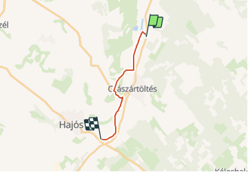
K■ (Hajós-Császártöltés)

SityTrail - itinéraires balisés pédestres
Tous les sentiers balisés d’Europe GUIDE+

Length
11.2 km

Max alt
108 m

Uphill gradient
79 m
Km-Effort
12.2 km

Min alt
84 m

Downhill gradient
81 m
Boucle
No

Signpost
Creation date :
2022-02-21 10:35:02.261
Updated on :
2022-03-08 22:10:14.462
2h46
Difficulty : Easy

FREE GPS app for hiking
 SityTrail
IGN / Geographical institutes
SityTrail World
The world is yours!
About
Trail On foot of 11.2 km to be discovered at Great Plain and North, Bács-Kiskun, Császártöltés. This trail is proposed by SityTrail - itinéraires balisés pédestres.
Photos
 - Photo 1")
 - Photo 2")
Positioning
Country:
Hungary
Region :
Great Plain and North
Department/Province :
Bács-Kiskun
Municipality :
Császártöltés
Location:
Unknown
Start:(Dec)
Start:(UTM)
361204 ; 5146600 (34T) N.
Comments
Trails nearby