


P+ (Sárbogárd - Nagylók - Sárkány-tó)

SityTrail - itinéraires balisés pédestres
Tous les sentiers balisés d’Europe GUIDE+
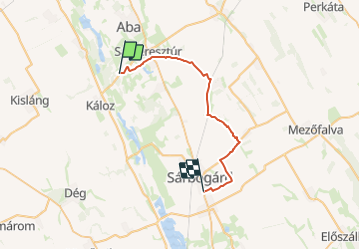

Length
29 km

Max alt
159 m

Uphill gradient
190 m
Km-Effort
32 km

Min alt
95 m

Downhill gradient
174 m
Boucle
No

Signpost
Creation date :
2022-02-21 10:33:35.808
Updated on :
2022-03-08 21:46:42.826
7h15
Difficulty : Difficult

FREE GPS app for hiking
 SityTrail
IGN / Geographical institutes
SityTrail World
The world is yours!
About
Trail On foot of 29 km to be discovered at Transdanubia, Fejér, Sárkeresztúr. This trail is proposed by SityTrail - itinéraires balisés pédestres.
Photos
 - Photo 1")
 - Photo 2")
 - Photo 3")
 - Photo 4")
 - Photo 5")
 - Photo 6")
Positioning
Country:
Hungary
Region :
Transdanubia
Department/Province :
Fejér
Municipality :
Sárkeresztúr
Location:
Unknown
Start:(Dec)
Start:(UTM)
310609 ; 5206435 (34T) N.
Comments
Trails nearby