![](/images/other/stat-length.png)
![Trail On foot Unknown - P+ - Photo](https://media.geolcdn.com/t/1900/400/eb46dc8b-ef3c-4c3f-8de1-14447e1d97b5.jpeg&format=pjpeg&maxdim=2)
P+
SityTrail - itinéraires balisés pédestres
Tous les sentiers balisés d’Europe GUIDE+
![Length](/images/other/stat-length.png)
Length
11.8 km
![Max alt](https://static1.geolcdn.com/siteimages/upload/files/1508320355ic_sort_altitude_max_24dp.png)
Max alt
224 m
![Uphill gradient](https://static1.geolcdn.com/siteimages/upload/files/1508320355ic_sort_den_pos_24dp.png)
Uphill gradient
116 m
![Km-Effort](/images/other/stat-length.png)
Km-Effort
13.5 km
![Min alt](https://static1.geolcdn.com/siteimages/upload/files/1508320355ic_sort_altitude_min_24dp.png)
Min alt
129 m
![Downhill gradient](https://static1.geolcdn.com/siteimages/upload/files/1508320355ic_sort_den_neg_24dp.png)
Downhill gradient
157 m
![Boucle](https://static1.geolcdn.com/siteimages/upload/files/16400158638029165_repeat_loop_refresh_sync_direction_icon.png)
Boucle
No
Signpost
Creation date :
2022-02-21 10:30:11.686
Updated on :
2022-03-08 20:50:11.578
![On foot](https://static1.geolcdn.com/sitytour/trail-icons/100.png)
3h04
Difficulty : Easy
![Scan this QR Code to open this trail in the SityTrail application](https://capi.geolives.com/qq0zvz2zws4bq2lad0pu/sitytour/trails/3138629/qr.png?size=200)
FREE GPS app for hiking
About
Trail On foot of 11.8 km to be discovered at Central Hungary, Budapest, Unknown. This trail is proposed by SityTrail - itinéraires balisés pédestres.
Description
Rákoshegy - Merzse-mocsár, és Csordakút utca - Pécel között felmérendő, és a Merzse-mocsár környéként nem egyértelmű a felfestése sem
Symbol: red cross
Positioning
Country:
Hungary
Region :
Central Hungary
Department/Province :
Budapest
Municipality :
Unknown
Location:
17th district
Start:(Dec)
Start:(UTM)
372663 ; 5260440 (34T) N.
Comments
Trails nearby
![Trail On foot Pécel - Z+ (Isaszeg Z - Pécel Z) - Photo](https://media.geolcdn.com/t/375/260/af226a0f-4bbc-413a-baaa-6477c87eae03.jpeg&format=jpg&maxdim=2)
![On foot On foot](https://static1.geolcdn.com/sitytour/trail-icons/100.png)
Z+ (Isaszeg Z - Pécel Z)
On foot
Easy
Pécel,
Central Hungary,
Pest megye,
Hungary
![](/images/other/stat-length.png)
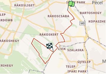
9.4 km | 12.2 km-effort
2h 45min
![](https://static1.geolcdn.com/siteimages/upload/files/16400158638029165_repeat_loop_refresh_sync_direction_icon.png)
No