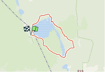
![](/images/other/stat-length.png)
![Trail On foot Unknown - Fornborgsslingan - Photo](https://media.geolcdn.com/t/1900/400/de330a5c-cf7f-49fc-9332-d6571a1c780b.jpeg&format=pjpeg&maxdim=2)
Fornborgsslingan
SityTrail - itinéraires balisés pédestres
Tous les sentiers balisés d’Europe GUIDE+
![Length](/images/other/stat-length.png)
Length
4.8 km
![Max alt](https://static1.geolcdn.com/siteimages/upload/files/1508320355ic_sort_altitude_max_24dp.png)
Max alt
74 m
![Uphill gradient](https://static1.geolcdn.com/siteimages/upload/files/1508320355ic_sort_den_pos_24dp.png)
Uphill gradient
72 m
![Km-Effort](/images/other/stat-length.png)
Km-Effort
5.8 km
![Min alt](https://static1.geolcdn.com/siteimages/upload/files/1508320355ic_sort_altitude_min_24dp.png)
Min alt
39 m
![Downhill gradient](https://static1.geolcdn.com/siteimages/upload/files/1508320355ic_sort_den_neg_24dp.png)
Downhill gradient
74 m
![Boucle](https://static1.geolcdn.com/siteimages/upload/files/16400158638029165_repeat_loop_refresh_sync_direction_icon.png)
Boucle
Yes
Signpost
Creation date :
2022-02-21 10:28:41.305
Updated on :
2022-03-08 20:17:04.96
![On foot](https://static1.geolcdn.com/sitytour/trail-icons/100.png)
1h18
Difficulty : Easy
![Scan this QR Code to open this trail in the SityTrail application](https://capi.geolives.com/qq0zvz2zws4bq2lad0pu/sitytour/trails/3138533/qr.png?size=200)
FREE GPS app for hiking
About
Trail On foot of 4.8 km to be discovered at Stockholm County. This trail is proposed by SityTrail - itinéraires balisés pédestres.
Description
Stiftelsen Tyrestaskogen ansvarar för förvaltning och utveckling av Tyresta nationalpark och naturreservat samt av naturum Nationalparkernas hus.
Website: https://www.tyresta.se/
Positioning
Country:
Sweden
Region :
Stockholm County
Department/Province :
Unknown
Municipality :
Unknown
Location:
Unknown
Start:(Dec)
Start:(UTM)
345984 ; 6563343 (34V) N.
Comments
Trails nearby
![Trail On foot - Åvaleden - Photo](https://media.geolcdn.com/t/375/260/6c68b8f4-d233-4646-b028-09c42ae7739e.jpeg&format=jpg&maxdim=2)
![On foot On foot](https://static1.geolcdn.com/sitytour/trail-icons/100.png)
![Trail On foot - Sjöarna runt - Photo](https://media.geolcdn.com/t/375/260/cf90954d-f7d4-4d7b-99ef-29bb924d70b7.jpeg&format=jpg&maxdim=2)
![On foot On foot](https://static1.geolcdn.com/sitytour/trail-icons/100.png)
![Trail On foot - Barnvagnsslingan - Photo](https://media.geolcdn.com/t/375/260/09bee64c-c4a6-4806-98a5-af92ab49a89b.jpeg&format=jpg&maxdim=2)
![On foot On foot](https://static1.geolcdn.com/sitytour/trail-icons/100.png)
![Trail On foot - Åvaträskslingan - Photo](https://media.geolcdn.com/t/375/260/c1185afe-15bd-41f5-9bda-bbc4d0df5215.jpeg&format=jpg&maxdim=2)
![On foot On foot](https://static1.geolcdn.com/sitytour/trail-icons/100.png)
![Trail On foot - Kustleden - Photo](https://media.geolcdn.com/t/375/260/0c270590-840a-4dea-96e8-98e8bcdc824a.jpeg&format=jpg&maxdim=2)
![On foot On foot](https://static1.geolcdn.com/sitytour/trail-icons/100.png)
![Trail On foot - Hällmarksslingan - Photo](https://media.geolcdn.com/t/375/260/d172c898-3a3b-4b08-87bd-bc9dabe6fd56.jpeg&format=jpg&maxdim=2)
![On foot On foot](https://static1.geolcdn.com/sitytour/trail-icons/100.png)
![Trail On foot - Storskogsslingan - Photo](https://media.geolcdn.com/t/375/260/706deca5-5d30-4ce9-b261-dac30fd1faa8.jpeg&format=jpg&maxdim=2)
![On foot On foot](https://static1.geolcdn.com/sitytour/trail-icons/100.png)
![Trail On foot - Bylsjöslingan - Photo](https://media.geolcdn.com/t/375/260/2337c454-98fb-45e0-b09a-02cd6197093e.jpeg&format=jpg&maxdim=2)
![On foot On foot](https://static1.geolcdn.com/sitytour/trail-icons/100.png)
![Trail Walking - 2024-08-23 Sörmlandsleden 4 - Photo](https://media.geolcdn.com/t/375/260/ext.jpg?maxdim=2&url=https%3A%2F%2Fstatic1.geolcdn.com%2Fsiteimages%2Fupload%2Ffiles%2F1553511878bg_sport_marche.png)
![Walking Walking](https://static1.geolcdn.com/sitytour/trail-icons/101.png)
2024-08-23 Sörmlandsleden 4
Walking
Easy
,
Stockholm County,
,
Sweden
![](/images/other/stat-length.png)
11.2 km | 12.7 km-effort
3h 14min
![](https://static1.geolcdn.com/siteimages/upload/files/16400158638029165_repeat_loop_refresh_sync_direction_icon.png)
No