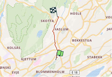
![](/images/other/stat-length.png)
![Trail On foot Unknown - Turvei H1: Høvikodden-Øverland - Photo](https://media.geolcdn.com/t/1900/400/726ef449-5b70-4a53-b1e0-5667828293b2.jpeg&format=pjpeg&maxdim=2)
Turvei H1: Høvikodden-Øverland
SityTrail - itinéraires balisés pédestres
Tous les sentiers balisés d’Europe GUIDE+
![Length](/images/other/stat-length.png)
Length
3.4 km
![Max alt](https://static1.geolcdn.com/siteimages/upload/files/1508320355ic_sort_altitude_max_24dp.png)
Max alt
116 m
![Uphill gradient](https://static1.geolcdn.com/siteimages/upload/files/1508320355ic_sort_den_pos_24dp.png)
Uphill gradient
100 m
![Km-Effort](/images/other/stat-length.png)
Km-Effort
4.5 km
![Min alt](https://static1.geolcdn.com/siteimages/upload/files/1508320355ic_sort_altitude_min_24dp.png)
Min alt
26 m
![Downhill gradient](https://static1.geolcdn.com/siteimages/upload/files/1508320355ic_sort_den_neg_24dp.png)
Downhill gradient
15 m
![Boucle](https://static1.geolcdn.com/siteimages/upload/files/16400158638029165_repeat_loop_refresh_sync_direction_icon.png)
Boucle
No
Signpost
Creation date :
2022-02-21 10:24:54.422
Updated on :
2022-03-08 19:23:56.517
![On foot](https://static1.geolcdn.com/sitytour/trail-icons/100.png)
1h01
Difficulty : Easy
![Scan this QR Code to open this trail in the SityTrail application](https://capi.geolives.com/qq0zvz2zws4bq2lad0pu/sitytour/trails/3138301/qr.png?size=200)
FREE GPS app for hiking
About
Trail On foot of 3.4 km to be discovered at Viken. This trail is proposed by SityTrail - itinéraires balisés pédestres.
Description
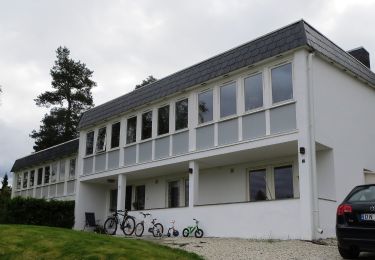
Trail created by Bærum kommune.
Oppgitt fra Høvikodden;Blommenholm, men ikke skiltet før Kloppa
Symbol: signposted
Positioning
Country:
Norway
Region :
Viken
Department/Province :
Unknown
Municipality :
Unknown
Location:
Unknown
Start:(Dec)
Start:(UTM)
587186 ; 6642033 (32V) N.
Comments
Trails nearby
![Trail On foot - Turvei N1: Ankerveien - Photo](https://media.geolcdn.com/t/375/260/e90feae7-8d5f-458e-a8ee-33536f04973d.jpeg&format=jpg&maxdim=2)
![On foot On foot](https://static1.geolcdn.com/sitytour/trail-icons/100.png)
![Trail On foot - Turvei K1: Strand-Haug (Ankerveien) - Photo](https://media.geolcdn.com/t/375/260/05fba1b7-bc3f-42ff-8bbc-4197f9b70feb.jpeg&format=jpg&maxdim=2)
![On foot On foot](https://static1.geolcdn.com/sitytour/trail-icons/100.png)
Turvei K1: Strand-Haug (Ankerveien)
On foot
Easy
,
Viken,
,
Norway
![](/images/other/stat-length.png)
5.2 km | 5.8 km-effort
1h 19min
![](https://static1.geolcdn.com/siteimages/upload/files/16400158638029165_repeat_loop_refresh_sync_direction_icon.png)
No
![Trail On foot - Turvei J1: Sandvika-Eiksmarka (Ankerveien) - Photo](https://media.geolcdn.com/t/375/260/eb6507f9-cb85-4083-97f7-eb1a4338d201.jpeg&format=jpg&maxdim=2)
![On foot On foot](https://static1.geolcdn.com/sitytour/trail-icons/100.png)
Turvei J1: Sandvika-Eiksmarka (Ankerveien)
On foot
Easy
,
Viken,
,
Norway
![](/images/other/stat-length.png)
11.5 km | 14.3 km-effort
3h 14min
![](https://static1.geolcdn.com/siteimages/upload/files/16400158638029165_repeat_loop_refresh_sync_direction_icon.png)
No
![Trail On foot - Turvei I1: Plathebukta-Nordli (Ankerveien) - Photo](https://media.geolcdn.com/t/375/260/cc7f7877-f4da-42ab-b3d1-c2b6485b8ad8.jpeg&format=jpg&maxdim=2)
![On foot On foot](https://static1.geolcdn.com/sitytour/trail-icons/100.png)
Turvei I1: Plathebukta-Nordli (Ankerveien)
On foot
Easy
,
Viken,
,
Norway
![](/images/other/stat-length.png)
9.4 km | 12 km-effort
2h 44min
![](https://static1.geolcdn.com/siteimages/upload/files/16400158638029165_repeat_loop_refresh_sync_direction_icon.png)
No
![Trail On foot - Turvei H2: Sandvika-Haslum - Photo](https://media.geolcdn.com/t/375/260/c6f2a30b-6c94-43a5-860a-07944804eb4c.jpeg&format=jpg&maxdim=2)
![On foot On foot](https://static1.geolcdn.com/sitytour/trail-icons/100.png)
![Trail On foot - Turvei G1: Sandvika-Valler - Photo](https://media.geolcdn.com/t/375/260/8c91683b-1d80-41d3-8b0b-dcee03341b67.jpeg&format=jpg&maxdim=2)
![On foot On foot](https://static1.geolcdn.com/sitytour/trail-icons/100.png)
![Trail On foot - Tursti Lysakerelva - Photo](https://media.geolcdn.com/t/375/260/8c50885a-8aa2-45b4-a458-6d8d00a5a5bf.jpeg&format=jpg&maxdim=2)
![On foot On foot](https://static1.geolcdn.com/sitytour/trail-icons/100.png)
![Trail On foot - Turvei A2: Bjørnegård-Vestmarkveien - Photo](https://media.geolcdn.com/t/375/260/ff9e9644-a166-4879-8a0d-ce1d9a7cca07.jpeg&format=jpg&maxdim=2)
![On foot On foot](https://static1.geolcdn.com/sitytour/trail-icons/100.png)
Turvei A2: Bjørnegård-Vestmarkveien
On foot
Easy
,
Viken,
,
Norway
![](/images/other/stat-length.png)
4.5 km | 6.5 km-effort
1h 29min
![](https://static1.geolcdn.com/siteimages/upload/files/16400158638029165_repeat_loop_refresh_sync_direction_icon.png)
No
![Trail On foot Unknown - Turvei A12 - Photo](https://media.geolcdn.com/t/375/260/1e3ca4b1-1811-4e34-a693-b9054707923f.jpeg&format=jpg&maxdim=2)
![On foot On foot](https://static1.geolcdn.com/sitytour/trail-icons/100.png)