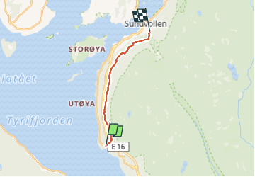
![](/images/other/stat-length.png)
![Trail On foot Unknown - Tursti Sundvollen-Nes - Photo](https://media.geolcdn.com/t/1900/400/1cca853f-7bf7-4c35-bc3e-3423485edfed.jpeg&format=pjpeg&maxdim=2)
Tursti Sundvollen-Nes
SityTrail - itinéraires balisés pédestres
Tous les sentiers balisés d’Europe GUIDE+
![Length](/images/other/stat-length.png)
Length
8.3 km
![Max alt](https://static1.geolcdn.com/siteimages/upload/files/1508320355ic_sort_altitude_max_24dp.png)
Max alt
292 m
![Uphill gradient](https://static1.geolcdn.com/siteimages/upload/files/1508320355ic_sort_den_pos_24dp.png)
Uphill gradient
283 m
![Km-Effort](/images/other/stat-length.png)
Km-Effort
12.1 km
![Min alt](https://static1.geolcdn.com/siteimages/upload/files/1508320355ic_sort_altitude_min_24dp.png)
Min alt
108 m
![Downhill gradient](https://static1.geolcdn.com/siteimages/upload/files/1508320355ic_sort_den_neg_24dp.png)
Downhill gradient
285 m
![Boucle](https://static1.geolcdn.com/siteimages/upload/files/16400158638029165_repeat_loop_refresh_sync_direction_icon.png)
Boucle
No
Signpost
Creation date :
2022-02-21 10:18:55.143
Updated on :
2022-03-08 17:01:30.851
![On foot](https://static1.geolcdn.com/sitytour/trail-icons/100.png)
2h44
Difficulty : Easy
![Scan this QR Code to open this trail in the SityTrail application](https://capi.geolives.com/qq0zvz2zws4bq2lad0pu/sitytour/trails/3137819/qr.png?size=200)
FREE GPS app for hiking
About
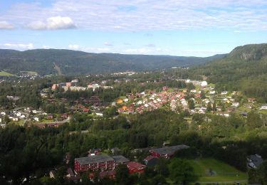
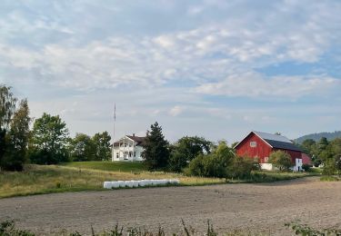
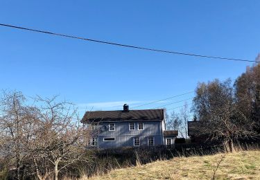
Trail On foot of 8.3 km to be discovered at Viken. This trail is proposed by SityTrail - itinéraires balisés pédestres.
Description
Trail created by Hole kommune.
Symbol: Light blue 10x5 cm rectangles
Positioning
Country:
Norway
Region :
Viken
Department/Province :
Unknown
Municipality :
Unknown
Location:
Unknown
Start:(Dec)
Start:(UTM)
570914 ; 6652414 (32V) N.
Comments
Trails nearby
![Trail On foot - NO-Proposed trailblazing - Photo](https://media.geolcdn.com/t/375/260/e1d8d2ab-e1ab-4ea4-96c1-4393f211e5ed.jpeg&format=jpg&maxdim=2)
![On foot On foot](https://static1.geolcdn.com/sitytour/trail-icons/100.png)
![Trail On foot - Turvei N1: Ankerveien - Photo](https://media.geolcdn.com/t/375/260/e90feae7-8d5f-458e-a8ee-33536f04973d.jpeg&format=jpg&maxdim=2)
![On foot On foot](https://static1.geolcdn.com/sitytour/trail-icons/100.png)
![Trail On foot - Turvei K1: Strand-Haug (Ankerveien) - Photo](https://media.geolcdn.com/t/375/260/05fba1b7-bc3f-42ff-8bbc-4197f9b70feb.jpeg&format=jpg&maxdim=2)
![On foot On foot](https://static1.geolcdn.com/sitytour/trail-icons/100.png)
Turvei K1: Strand-Haug (Ankerveien)
On foot
Easy
,
Viken,
,
Norway
![](/images/other/stat-length.png)
5.2 km | 5.8 km-effort
1h 19min
![](https://static1.geolcdn.com/siteimages/upload/files/16400158638029165_repeat_loop_refresh_sync_direction_icon.png)
No
![Trail On foot - Turvei J1: Sandvika-Eiksmarka (Ankerveien) - Photo](https://media.geolcdn.com/t/375/260/eb6507f9-cb85-4083-97f7-eb1a4338d201.jpeg&format=jpg&maxdim=2)
![On foot On foot](https://static1.geolcdn.com/sitytour/trail-icons/100.png)
Turvei J1: Sandvika-Eiksmarka (Ankerveien)
On foot
Easy
,
Viken,
,
Norway
![](/images/other/stat-length.png)
11.5 km | 14.3 km-effort
3h 14min
![](https://static1.geolcdn.com/siteimages/upload/files/16400158638029165_repeat_loop_refresh_sync_direction_icon.png)
No
![Trail On foot - Turvei I1: Plathebukta-Nordli (Ankerveien) - Photo](https://media.geolcdn.com/t/375/260/cc7f7877-f4da-42ab-b3d1-c2b6485b8ad8.jpeg&format=jpg&maxdim=2)
![On foot On foot](https://static1.geolcdn.com/sitytour/trail-icons/100.png)
Turvei I1: Plathebukta-Nordli (Ankerveien)
On foot
Easy
,
Viken,
,
Norway
![](/images/other/stat-length.png)
9.4 km | 12 km-effort
2h 44min
![](https://static1.geolcdn.com/siteimages/upload/files/16400158638029165_repeat_loop_refresh_sync_direction_icon.png)
No
![Trail On foot - Turvei H2: Sandvika-Haslum - Photo](https://media.geolcdn.com/t/375/260/c6f2a30b-6c94-43a5-860a-07944804eb4c.jpeg&format=jpg&maxdim=2)
![On foot On foot](https://static1.geolcdn.com/sitytour/trail-icons/100.png)
![Trail On foot - Turvei G1: Sandvika-Valler - Photo](https://media.geolcdn.com/t/375/260/8c91683b-1d80-41d3-8b0b-dcee03341b67.jpeg&format=jpg&maxdim=2)
![On foot On foot](https://static1.geolcdn.com/sitytour/trail-icons/100.png)
![Trail On foot - Turvei E1: Wøyen-Kirkeby - Photo](https://media.geolcdn.com/t/375/260/6fd02295-8bd1-48b4-bd9c-b8c1f8a071d0.jpeg&format=jpg&maxdim=2)
![On foot On foot](https://static1.geolcdn.com/sitytour/trail-icons/100.png)
![Trail On foot - Turvei D1: Økri-Gullhaug - Photo](https://media.geolcdn.com/t/375/260/bdc51594-619a-428d-b6bb-4c88c543e760.jpeg&format=jpg&maxdim=2)
![On foot On foot](https://static1.geolcdn.com/sitytour/trail-icons/100.png)