Trail On foot Sundsvall - Hälsans stig Sundsvall centrum - Photo

Hälsans stig Sundsvall centrum

Tous les sentiers balisés d’Europe GUIDE+

© OpenStreetMap contributors
Length
Length
4 km
Max alt
Max alt
21 m
Uphill gradient
Uphill gradient
27 m
Km-Effort
Km-Effort  
4.4 km
Min alt
Min alt
0 m
Downhill gradient
Downhill gradient
25 m
Boucle
Boucle
Yes
Signpost
Signpost
Creation date :
2022-02-21 10:15:00.34
Updated on :
2022-03-08 15:43:31.016

(0 Reviews)

On foot
On foot
59m
Difficulty : Easy

Scan this QR Code to open this trail in the SityTrail application

FREE GPS app for hiking

Logo SityTrail SityTrail

IGN / Geographical institutes

Download SityTrail from the App Store Download SityTrail from Google Play

Logo SityTrail SityTrail World

The world is yours!

Download SityTrail from the App Store Download SityTrail from Google Play Download SityTrail on Huawei AppGallery

About

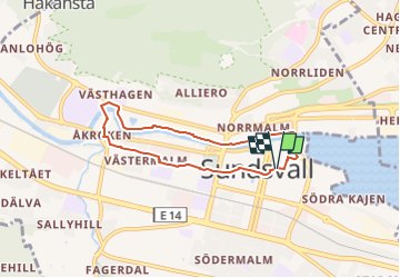
Trail On foot of 4 km to be discovered at Västernorrland County, Unknown, Sundsvall. This trail is proposed by SityTrail - itinéraires balisés pédestres.

Description

Trail created by Hjärt- och Lungsjukas riksförbund.

Symbol: Blue and yellow sign

Elevation profile

Photos

Positioning

Country:
Sweden
Region :
Västernorrland County
Department/Province :
Unknown
Municipality :
Sundsvall
Location:
Centrum
Start:(UTM)
619429 ; 6919846 (33V) N.

Trails nearby

Trail On foot Selånger District - Gusturleden - Photo
On foot
GUIDE+

On foot

Easy
Selånger District, Västernorrland County, Unknown, Sweden
10.6 km | 13.4 km-effort
3h 3min
No


Close
My subscriptions