Trail On foot Vettelschoß - LZ11 - Rundwanderweg Kalenborn - Photo

Tous les sentiers balisés d’Europe GUIDE+

© OpenStreetMap contributors
Length
Length
4.2 km
Max alt
Max alt
367 m
Uphill gradient
Uphill gradient
95 m
Km-Effort
Km-Effort  
5.4 km
Min alt
Min alt
306 m
Downhill gradient
Downhill gradient
97 m
Boucle
Boucle
Yes
Signpost
Signpost
Creation date :
2022-02-21 08:29:11.869
Updated on :
2022-02-21 08:29:11.869

(0 Reviews)

On foot
On foot
1h14
Difficulty : Easy

Scan this QR Code to open this trail in the SityTrail application

FREE GPS app for hiking

Logo SityTrail SityTrail

IGN / Geographical institutes

Download SityTrail from the App Store Download SityTrail from Google Play

Logo SityTrail SityTrail World

The world is yours!

Download SityTrail from the App Store Download SityTrail from Google Play Download SityTrail on Huawei AppGallery

About

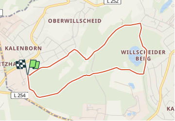
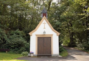
Trail On foot of 4.2 km to be discovered at Rhineland-Palatinate, Landkreis Neuwied, Vettelschoß. This trail is proposed by SityTrail - itinéraires balisés pédestres.

Description

Trail created by Verbandsgemeinde Linz am Rhein.

Symbol: weisse LZ11 auf rotem Grund

Elevation profile

Positioning

Country:
Germany
Region :
Rhineland-Palatinate
Department/Province :
Landkreis Neuwied
Municipality :
Vettelschoß
Location:
Unknown
Start:(UTM)
380773 ; 5608121 (32U) N.

Trails nearby

Trail On foot Bruchhausen - Rotbäckchen Rundwanderweg - Photo
On foot
GUIDE+

On foot

Easy
Bruchhausen, Rhineland-Palatinate, Landkreis Neuwied, Germany
11.1 km | 14.1 km-effort
3h 11min
Yes
Trail On foot Windhagen - [W2] Windhagener Weg - Photo
On foot
GUIDE+

On foot

Easy
Windhagen, Rhineland-Palatinate, Landkreis Neuwied, Germany
6.9 km | 8.8 km-effort
1h 59min
Yes
Trail On foot Vettelschoß - Vettelschoß Rundwanderweg R12 - Photo
On foot
GUIDE+

On foot

Easy
Vettelschoß, Rhineland-Palatinate, Landkreis Neuwied, Germany
4.9 km | 7.1 km-effort
1h 37min
No
Trail On foot Vettelschoß - Rheinsteig-Zuweg Kalenborn - Photo
On foot
GUIDE+

On foot

Easy
Vettelschoß, Rhineland-Palatinate, Landkreis Neuwied, Germany
7.5 km | 9.3 km-effort
2h 6min
No
Trail On foot Windhagen - [W1] Stockhauser Weg - Photo
On foot
GUIDE+

On foot

Easy
Windhagen, Rhineland-Palatinate, Landkreis Neuwied, Germany
8.6 km | 11 km-effort
2h 30min
Yes
Trail On foot  - Rundweg Strödter Hügel - Photo
On foot
GUIDE+

On foot

Easy
, Rhineland-Palatinate, Landkreis Neuwied, Germany
6.2 km | 8.4 km-effort
1h 55min
Yes
Trail On foot Ockenfels - LZ15 - Rundwanderweg Ockenfels - Photo
On foot
GUIDE+

On foot

Easy
Ockenfels, Rhineland-Palatinate, Landkreis Neuwied, Germany
6.2 km | 8.1 km-effort
1h 51min
Yes
Trail On foot Linz am Rhein - LZ13 - Rundwanderweg Minderberg - Photo
On foot
GUIDE+

On foot

Easy
Linz am Rhein, Rhineland-Palatinate, Landkreis Neuwied, Germany
5.1 km | 7.2 km-effort
1h 37min
Yes
Trail On foot Vettelschoß - LZ12 - Rundwanderweg Vettelschoß - Photo
On foot
GUIDE+

On foot

Easy
Vettelschoß, Rhineland-Palatinate, Landkreis Neuwied, Germany
3.9 km | 5.1 km-effort
1h 10min
Yes


Close
My subscriptions