Trail On foot Johanngeorgenstadt - Ringweg Rabenberg - Photo

Tous les sentiers balisés d’Europe GUIDE+

© OpenStreetMap contributors
Length
Length
10.1 km
Max alt
Max alt
913 m
Uphill gradient
Uphill gradient
296 m
Km-Effort
Km-Effort  
14 km
Min alt
Min alt
664 m
Downhill gradient
Downhill gradient
298 m
Boucle
Boucle
Yes
Signpost
Signpost
Creation date :
2022-02-21 08:20:53.13
Updated on :
2022-02-21 08:20:53.13

(0 Reviews)

On foot
On foot
3h11
Difficulty : Easy

Scan this QR Code to open this trail in the SityTrail application

FREE GPS app for hiking

Logo SityTrail SityTrail

IGN / Geographical institutes

Download SityTrail from the App Store Download SityTrail from Google Play

Logo SityTrail SityTrail World

The world is yours!

Download SityTrail from the App Store Download SityTrail from Google Play Download SityTrail on Huawei AppGallery

About

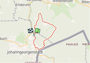
Trail On foot of 10.1 km to be discovered at Saxony, Erzgebirgskreis, Johanngeorgenstadt. This trail is proposed by SityTrail - itinéraires balisés pédestres.

Description

Symbol: gelber Strich, weißer Grund

Elevation profile

Positioning

Country:
Germany
Region :
Saxony
Department/Province :
Erzgebirgskreis
Municipality :
Johanngeorgenstadt
Location:
Unknown
Start:(UTM)
338661 ; 5590540 (33U) N.

Trails nearby

Trail On foot Potůčky - NS Blatná - Vlčí jámy - Photo
On foot
GUIDE+

On foot

Easy
Potůčky, Northwest, Karlovarský kraj, Czech Republic
3.2 km | 5.1 km-effort
1h 9min
Yes
Trail On foot Horní Blatná - NS Blatenský příkop - Photo
On foot
GUIDE+

On foot

Easy
Horní Blatná, Northwest, Karlovarský kraj, Czech Republic
10.8 km | 12.1 km-effort
2h 44min
No
Trail On foot Potůčky - [Ž] Pernink - Nové Hamry - Photo
On foot
GUIDE+

On foot

Medium
Potůčky, Northwest, Karlovarský kraj, Czech Republic
21 km | 30 km-effort
6h 53min
No
Trail On foot Johanngeorgenstadt - Ww Johann-Georgenstadt - Rabenberg - Breitenbrunn - Photo
On foot
GUIDE+

On foot

Easy
Johanngeorgenstadt, Saxony, Erzgebirgskreis, Germany
8.2 km | 12.8 km-effort
2h 54min
No
Trail On foot Breitenbrunn/Erzgebirge - Ww Breitenbrunn - Klughaus - Anschluß Richtung Halbmeile - Photo
On foot
GUIDE+

On foot

Easy
Breitenbrunn/Erzgebirge, Saxony, Erzgebirgskreis, Germany
3.6 km | 5.6 km-effort
1h 16min
No
Trail On foot Breitenbrunn/Erzgebirge - Ww Zittau - Wernigerode Teilstück, teilweise auch Weg der deutschen Einheit - Photo
On foot
GUIDE+

On foot

Medium
Breitenbrunn/Erzgebirge, Saxony, Erzgebirgskreis, Germany
18.4 km | 27 km-effort
6h 4min
No


Close
My subscriptions