![](/images/other/stat-length.png)
![Trail On foot Jöhstadt - Ww Rundweg Jöhstadt - Photo](https://media.geolcdn.com/t/1900/400/ext.pjpeg?maxdim=2&url=https%3A%2F%2Fstatic1.geolcdn.com%2Fsiteimages%2Fupload%2Ffiles%2F1545311037marcheuse_200dpi.jpg)
Ww Rundweg Jöhstadt
SityTrail - itinéraires balisés pédestres
Tous les sentiers balisés d’Europe GUIDE+
![Length](/images/other/stat-length.png)
Length
7.2 km
![Max alt](https://static1.geolcdn.com/siteimages/upload/files/1508320355ic_sort_altitude_max_24dp.png)
Max alt
814 m
![Uphill gradient](https://static1.geolcdn.com/siteimages/upload/files/1508320355ic_sort_den_pos_24dp.png)
Uphill gradient
189 m
![Km-Effort](/images/other/stat-length.png)
Km-Effort
9.7 km
![Min alt](https://static1.geolcdn.com/siteimages/upload/files/1508320355ic_sort_altitude_min_24dp.png)
Min alt
664 m
![Downhill gradient](https://static1.geolcdn.com/siteimages/upload/files/1508320355ic_sort_den_neg_24dp.png)
Downhill gradient
183 m
![Boucle](https://static1.geolcdn.com/siteimages/upload/files/16400158638029165_repeat_loop_refresh_sync_direction_icon.png)
Boucle
Yes
Signpost
Creation date :
2022-02-21 08:19:00.815
Updated on :
2022-02-21 08:19:00.815
![On foot](https://static1.geolcdn.com/sitytour/trail-icons/100.png)
2h12
Difficulty : Easy
![Scan this QR Code to open this trail in the SityTrail application](https://capi.geolives.com/qq0zvz2zws4bq2lad0pu/sitytour/trails/3136704/qr.png?size=200)
FREE GPS app for hiking
About
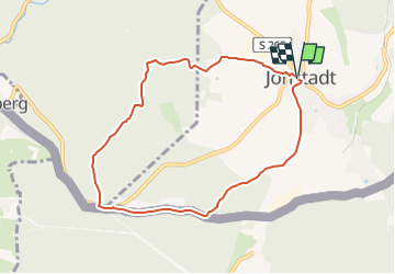
Trail On foot of 7.2 km to be discovered at Saxony, Erzgebirgskreis, Jöhstadt. This trail is proposed by SityTrail - itinéraires balisés pédestres.
Description
Symbol: gelber Strich weißer gGund
Positioning
Country:
Germany
Region :
Saxony
Department/Province :
Erzgebirgskreis
Municipality :
Jöhstadt
Location:
Unknown
Start:(Dec)
Start:(UTM)
364544 ; 5597534 (33U) N.
Comments
Trails nearby
![Trail On foot Kryštofovy Hamry - [Ž] Přísečnice - Kryštofovy Hamry (CZ/D) - Photo](https://media.geolcdn.com/t/375/260/03c08e34-bb16-4dca-b0b7-852ffa6612cc.jpeg&format=jpg&maxdim=2)
![On foot On foot](https://static1.geolcdn.com/sitytour/trail-icons/100.png)
[Ž] Přísečnice - Kryštofovy Hamry (CZ/D)
On foot
Easy
Kryštofovy Hamry,
Northwest,
Ústecký kraj,
Czech Republic
![](/images/other/stat-length.png)
3.6 km | 4.1 km-effort
56min
![](https://static1.geolcdn.com/siteimages/upload/files/16400158638029165_repeat_loop_refresh_sync_direction_icon.png)
No
![Trail On foot Jöhstadt - Ww Großer Ringweg Steinbach - Photo](https://media.geolcdn.com/t/375/260/85c12a38-d9c2-47ea-bf62-497a950230a9.jpeg&format=jpg&maxdim=2)
![On foot On foot](https://static1.geolcdn.com/sitytour/trail-icons/100.png)
Ww Großer Ringweg Steinbach
On foot
Easy
Jöhstadt,
Saxony,
Erzgebirgskreis,
Germany
![](/images/other/stat-length.png)
10.5 km | 15 km-effort
3h 23min
![](https://static1.geolcdn.com/siteimages/upload/files/16400158638029165_repeat_loop_refresh_sync_direction_icon.png)
Yes
![Trail On foot Bärenstein - Ww Bärenstein, Parkplatz am Fuße des Berges-Richtung Kretscham-Rothensehma - Photo](https://media.geolcdn.com/t/375/260/ext.jpg?maxdim=2&url=https%3A%2F%2Fstatic1.geolcdn.com%2Fsiteimages%2Fupload%2Ffiles%2F1545311037marcheuse_200dpi.jpg)
![On foot On foot](https://static1.geolcdn.com/sitytour/trail-icons/100.png)
Ww Bärenstein, Parkplatz am Fuße des Berges-Richtung Kretscham-Rothensehma
On foot
Easy
Bärenstein,
Saxony,
Erzgebirgskreis,
Germany
![](/images/other/stat-length.png)
4.1 km | 5.3 km-effort
1h 12min
![](https://static1.geolcdn.com/siteimages/upload/files/16400158638029165_repeat_loop_refresh_sync_direction_icon.png)
No
![Trail On foot Jöhstadt - Ww Schmalzgrube - Steinbach - Photo](https://media.geolcdn.com/t/375/260/ext.jpg?maxdim=2&url=https%3A%2F%2Fstatic1.geolcdn.com%2Fsiteimages%2Fupload%2Ffiles%2F1545311037marcheuse_200dpi.jpg)
![On foot On foot](https://static1.geolcdn.com/sitytour/trail-icons/100.png)
Ww Schmalzgrube - Steinbach
On foot
Easy
Jöhstadt,
Saxony,
Erzgebirgskreis,
Germany
![](/images/other/stat-length.png)
3.7 km | 5.2 km-effort
1h 10min
![](https://static1.geolcdn.com/siteimages/upload/files/16400158638029165_repeat_loop_refresh_sync_direction_icon.png)
No
![Trail On foot Königswalde - Ww Brettmühle-Annaberg - Photo](https://media.geolcdn.com/t/375/260/ext.jpg?maxdim=2&url=https%3A%2F%2Fstatic1.geolcdn.com%2Fsiteimages%2Fupload%2Ffiles%2F1545311037marcheuse_200dpi.jpg)
![On foot On foot](https://static1.geolcdn.com/sitytour/trail-icons/100.png)
Ww Brettmühle-Annaberg
On foot
Easy
Königswalde,
Saxony,
Erzgebirgskreis,
Germany
![](/images/other/stat-length.png)
6.1 km | 8.6 km-effort
1h 57min
![](https://static1.geolcdn.com/siteimages/upload/files/16400158638029165_repeat_loop_refresh_sync_direction_icon.png)
No
![Trail On foot Jöhstadt - Ww Ringweg um Grumbach, Markierung mangelhaft - Photo](https://media.geolcdn.com/t/375/260/ext.jpg?maxdim=2&url=https%3A%2F%2Fstatic1.geolcdn.com%2Fsiteimages%2Fupload%2Ffiles%2F1545311037marcheuse_200dpi.jpg)
![On foot On foot](https://static1.geolcdn.com/sitytour/trail-icons/100.png)
Ww Ringweg um Grumbach, Markierung mangelhaft
On foot
Easy
Jöhstadt,
Saxony,
Erzgebirgskreis,
Germany
![](/images/other/stat-length.png)
6.1 km | 7.7 km-effort
1h 45min
![](https://static1.geolcdn.com/siteimages/upload/files/16400158638029165_repeat_loop_refresh_sync_direction_icon.png)
No
![Trail On foot Jöhstadt - Ww Grumbach-Steinbach - Photo](https://media.geolcdn.com/t/375/260/ext.jpg?maxdim=2&url=https%3A%2F%2Fstatic1.geolcdn.com%2Fsiteimages%2Fupload%2Ffiles%2F1545311037marcheuse_200dpi.jpg)
![On foot On foot](https://static1.geolcdn.com/sitytour/trail-icons/100.png)
Ww Grumbach-Steinbach
On foot
Easy
Jöhstadt,
Saxony,
Erzgebirgskreis,
Germany
![](/images/other/stat-length.png)
4 km | 4.8 km-effort
1h 5min
![](https://static1.geolcdn.com/siteimages/upload/files/16400158638029165_repeat_loop_refresh_sync_direction_icon.png)
No
![Trail On foot Jöhstadt - Ww Schlössel-Grumbach - Photo](https://media.geolcdn.com/t/375/260/ext.jpg?maxdim=2&url=https%3A%2F%2Fstatic1.geolcdn.com%2Fsiteimages%2Fupload%2Ffiles%2F1545311037marcheuse_200dpi.jpg)
![On foot On foot](https://static1.geolcdn.com/sitytour/trail-icons/100.png)
Ww Schlössel-Grumbach
On foot
Easy
Jöhstadt,
Saxony,
Erzgebirgskreis,
Germany
![](/images/other/stat-length.png)
4.7 km | 6.7 km-effort
1h 30min
![](https://static1.geolcdn.com/siteimages/upload/files/16400158638029165_repeat_loop_refresh_sync_direction_icon.png)
No
![Trail On foot Jöhstadt - Ww Schmalzgrube-Jöhstadt - Photo](https://media.geolcdn.com/t/375/260/ext.jpg?maxdim=2&url=https%3A%2F%2Fstatic1.geolcdn.com%2Fsiteimages%2Fupload%2Ffiles%2F1545311037marcheuse_200dpi.jpg)
![On foot On foot](https://static1.geolcdn.com/sitytour/trail-icons/100.png)
Ww Schmalzgrube-Jöhstadt
On foot
Easy
Jöhstadt,
Saxony,
Erzgebirgskreis,
Germany
![](/images/other/stat-length.png)
3.7 km | 5.6 km-effort
1h 16min
![](https://static1.geolcdn.com/siteimages/upload/files/16400158638029165_repeat_loop_refresh_sync_direction_icon.png)
No