![](/images/other/stat-length.png)
![Trail On foot Wesenberg - DE-Symbol: Adler schwarz auf weißem Grund - Photo](https://media.geolcdn.com/t/1900/400/ext.pjpeg?maxdim=2&url=https%3A%2F%2Fstatic1.geolcdn.com%2Fsiteimages%2Fupload%2Ffiles%2F1545311037marcheuse_200dpi.jpg)
DE-Symbol: Adler schwarz auf weißem Grund
SityTrail - itinéraires balisés pédestres
Tous les sentiers balisés d’Europe PRO
![Length](/images/other/stat-length.png)
Length
14 km
![Max alt](https://static1.geolcdn.com/siteimages/upload/files/1508320355ic_sort_altitude_max_24dp.png)
Max alt
87 m
![Uphill gradient](https://static1.geolcdn.com/siteimages/upload/files/1508320355ic_sort_den_pos_24dp.png)
Uphill gradient
136 m
![Km-Effort](/images/other/stat-length.png)
Km-Effort
15.8 km
![Min alt](https://static1.geolcdn.com/siteimages/upload/files/1508320355ic_sort_altitude_min_24dp.png)
Min alt
59 m
![Downhill gradient](https://static1.geolcdn.com/siteimages/upload/files/1508320355ic_sort_den_neg_24dp.png)
Downhill gradient
133 m
![Boucle](https://static1.geolcdn.com/siteimages/upload/files/16400158638029165_repeat_loop_refresh_sync_direction_icon.png)
Boucle
Yes
Creation date :
2022-02-21 08:18:08.032
Updated on :
2022-02-21 08:18:08.032
![On foot](https://static1.geolcdn.com/sitytour/trail-icons/100.png)
3h35
Difficulty : Easy
![Scan this QR Code to open this trail in the SityTrail application](https://capi.geolives.com/qq0zvz2zws4bq2lad0pu/sitytour/trails/3136639/qr.png?size=200)
FREE GPS app for hiking
About
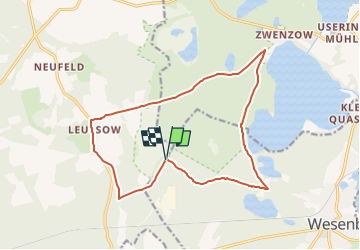
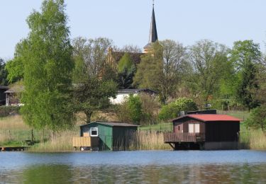
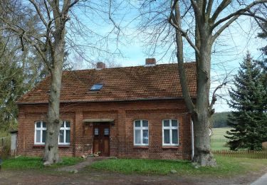
Trail On foot of 14 km to be discovered at Mecklenburg-Vorpommern, Mecklenburgische Seenplatte, Wesenberg. This trail is proposed by SityTrail - itinéraires balisés pédestres.
Description
Symbol: Adler schwarz auf weißem Grund
Positioning
Country:
Germany
Region :
Mecklenburg-Vorpommern
Department/Province :
Mecklenburgische Seenplatte
Municipality :
Wesenberg
Location:
Unknown
Start:(Dec)
Start:(UTM)
360524 ; 5907149 (33U) N.
Comments
Trails nearby
![Trail On foot Carpin - Rundwanderweg Graues Wildschwein - Photo](https://media.geolcdn.com/t/375/260/ext.jpg?maxdim=2&url=https%3A%2F%2Fmedia.geolcdn.com%2Ff%2F0c6c2ed0-1858-457c-87a5-6c06b408a38f.jpeg)
![On foot On foot](https://static1.geolcdn.com/sitytour/trail-icons/100.png)
Rundwanderweg Graues Wildschwein
On foot
Easy
Carpin,
Mecklenburg-Vorpommern,
Mecklenburgische Seenplatte,
Germany
![](/images/other/stat-length.png)
5.4 km | 6.6 km-effort
1h 29min
![](https://static1.geolcdn.com/siteimages/upload/files/16400158638029165_repeat_loop_refresh_sync_direction_icon.png)
Yes
![Trail On foot Schwarz - Rundweg Wummsee - Photo](https://media.geolcdn.com/t/375/260/ext.jpg?maxdim=2&url=https%3A%2F%2Fmedia.geolcdn.com%2Ff%2F27c079a9-1668-4d88-aca9-04d4ec7dd374.jpeg)
![On foot On foot](https://static1.geolcdn.com/sitytour/trail-icons/100.png)
Rundweg Wummsee
On foot
Easy
Schwarz,
Mecklenburg-Vorpommern,
Mecklenburgische Seenplatte,
Germany
![](/images/other/stat-length.png)
10.3 km | 12.4 km-effort
2h 48min
![](https://static1.geolcdn.com/siteimages/upload/files/16400158638029165_repeat_loop_refresh_sync_direction_icon.png)
No
![Trail On foot Mirow - Müritz-Nationalparkweg - Photo](https://media.geolcdn.com/t/375/260/ext.jpg?maxdim=2&url=https%3A%2F%2Fmedia.geolcdn.com%2Ff%2F09a666a5-da9a-480f-8452-602a72b92335.jpeg)
![On foot On foot](https://static1.geolcdn.com/sitytour/trail-icons/100.png)
Müritz-Nationalparkweg
On foot
Medium
Mirow,
Mecklenburg-Vorpommern,
Mecklenburgische Seenplatte,
Germany
![](/images/other/stat-length.png)
26 km | 29 km-effort
6h 39min
![](https://static1.geolcdn.com/siteimages/upload/files/16400158638029165_repeat_loop_refresh_sync_direction_icon.png)
No
![Trail On foot Rheinsberg - Geheimnisvolle Moore - Photo](https://media.geolcdn.com/t/375/260/ext.jpg?maxdim=2&url=https%3A%2F%2Fmedia.geolcdn.com%2Ff%2Fa8fe3738-b72f-4811-9577-27a8d77e72cf.jpeg)
![On foot On foot](https://static1.geolcdn.com/sitytour/trail-icons/100.png)
Geheimnisvolle Moore
On foot
Easy
Rheinsberg,
Brandenburg,
Ostprignitz-Ruppin,
Germany
![](/images/other/stat-length.png)
7.2 km | 8.6 km-effort
1h 57min
![](https://static1.geolcdn.com/siteimages/upload/files/16400158638029165_repeat_loop_refresh_sync_direction_icon.png)
No
![Trail On foot Wittstock/Dosse - Rundweg Wiesen, Felder und Auen - Photo](https://media.geolcdn.com/t/375/260/ext.jpg?maxdim=2&url=https%3A%2F%2Fmedia.geolcdn.com%2Ff%2F38a79c19-354d-4e27-a1b0-20605c584300.jpeg)
![On foot On foot](https://static1.geolcdn.com/sitytour/trail-icons/100.png)
Rundweg Wiesen, Felder und Auen
On foot
Easy
Wittstock/Dosse,
Brandenburg,
Ostprignitz-Ruppin,
Germany
![](/images/other/stat-length.png)
9.4 km | 10 km-effort
2h 16min
![](https://static1.geolcdn.com/siteimages/upload/files/16400158638029165_repeat_loop_refresh_sync_direction_icon.png)
Yes
![Trail On foot Kratzeburg - Um den Käbelicksee - Photo](https://media.geolcdn.com/t/375/260/ext.jpg?maxdim=2&url=https%3A%2F%2Fmedia.geolcdn.com%2Ff%2F93793eb2-b21b-4df0-977c-601b5302e3f1.jpeg)
![On foot On foot](https://static1.geolcdn.com/sitytour/trail-icons/100.png)
Um den Käbelicksee
On foot
Easy
Kratzeburg,
Mecklenburg-Vorpommern,
Mecklenburgische Seenplatte,
Germany
![](/images/other/stat-length.png)
8.8 km | 10 km-effort
2h 16min
![](https://static1.geolcdn.com/siteimages/upload/files/16400158638029165_repeat_loop_refresh_sync_direction_icon.png)
No
![Trail On foot - Rotes Eichhörnchen - Photo](https://media.geolcdn.com/t/375/260/ext.jpg?maxdim=2&url=https%3A%2F%2Fmedia.geolcdn.com%2Ff%2F27cd7bd0-944e-4760-9887-4e083af0d682.jpeg)
![On foot On foot](https://static1.geolcdn.com/sitytour/trail-icons/100.png)
Rotes Eichhörnchen
On foot
Easy
,
Mecklenburg-Vorpommern,
Mecklenburgische Seenplatte,
Germany
![](/images/other/stat-length.png)
3.8 km | 4.6 km-effort
1h 2min
![](https://static1.geolcdn.com/siteimages/upload/files/16400158638029165_repeat_loop_refresh_sync_direction_icon.png)
No
![Trail On foot Wokuhl-Dabelow - Stern-Godendorfer Papiermühle - Photo](https://media.geolcdn.com/t/375/260/ext.jpg?maxdim=2&url=https%3A%2F%2Fstatic1.geolcdn.com%2Fsiteimages%2Fupload%2Ffiles%2F1545311037marcheuse_200dpi.jpg)
![On foot On foot](https://static1.geolcdn.com/sitytour/trail-icons/100.png)
Stern-Godendorfer Papiermühle
On foot
Easy
Wokuhl-Dabelow,
Mecklenburg-Vorpommern,
Mecklenburgische Seenplatte,
Germany
![](/images/other/stat-length.png)
3.5 km | 4.1 km-effort
55min
![](https://static1.geolcdn.com/siteimages/upload/files/16400158638029165_repeat_loop_refresh_sync_direction_icon.png)
No
![Trail On foot Godendorf - Wokuhl-Godendorf - Photo](https://media.geolcdn.com/t/375/260/ext.jpg?maxdim=2&url=https%3A%2F%2Fstatic1.geolcdn.com%2Fsiteimages%2Fupload%2Ffiles%2F1545311037marcheuse_200dpi.jpg)
![On foot On foot](https://static1.geolcdn.com/sitytour/trail-icons/100.png)
Wokuhl-Godendorf
On foot
Easy
Godendorf,
Mecklenburg-Vorpommern,
Mecklenburgische Seenplatte,
Germany
![](/images/other/stat-length.png)
4.3 km | 4.9 km-effort
1h 6min
![](https://static1.geolcdn.com/siteimages/upload/files/16400158638029165_repeat_loop_refresh_sync_direction_icon.png)
No