![](/images/other/stat-length.png)
![Trail On foot Bad Salzschlirf - unknown - brown_oak_leaf - Photo](https://media.geolcdn.com/t/1900/400/ext.pjpeg?maxdim=2&url=https%3A%2F%2Fstatic1.geolcdn.com%2Fsiteimages%2Fupload%2Ffiles%2F1545311037marcheuse_200dpi.jpg)
unknown - brown_oak_leaf
SityTrail - itinéraires balisés pédestres
Tous les sentiers balisés d’Europe GUIDE+
![Length](/images/other/stat-length.png)
Length
11.4 km
![Max alt](https://static1.geolcdn.com/siteimages/upload/files/1508320355ic_sort_altitude_max_24dp.png)
Max alt
420 m
![Uphill gradient](https://static1.geolcdn.com/siteimages/upload/files/1508320355ic_sort_den_pos_24dp.png)
Uphill gradient
271 m
![Km-Effort](/images/other/stat-length.png)
Km-Effort
15.3 km
![Min alt](https://static1.geolcdn.com/siteimages/upload/files/1508320355ic_sort_altitude_min_24dp.png)
Min alt
246 m
![Downhill gradient](https://static1.geolcdn.com/siteimages/upload/files/1508320355ic_sort_den_neg_24dp.png)
Downhill gradient
356 m
![Boucle](https://static1.geolcdn.com/siteimages/upload/files/16400158638029165_repeat_loop_refresh_sync_direction_icon.png)
Boucle
No
Signpost
Creation date :
2022-02-21 08:15:26.716
Updated on :
2022-02-21 08:15:26.716
![On foot](https://static1.geolcdn.com/sitytour/trail-icons/100.png)
3h28
Difficulty : Easy
![Scan this QR Code to open this trail in the SityTrail application](https://capi.geolives.com/qq0zvz2zws4bq2lad0pu/sitytour/trails/3136405/qr.png?size=200)
FREE GPS app for hiking
About
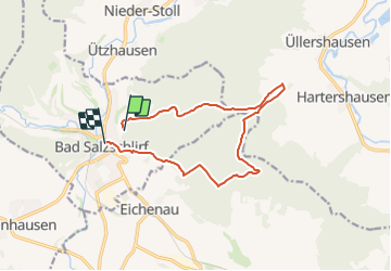
Trail On foot of 11.4 km to be discovered at Hesse, Landkreis Fulda, Bad Salzschlirf. This trail is proposed by SityTrail - itinéraires balisés pédestres.
Description
incomplete
Symbol: like http://wiki.openstreetmap.org/wiki/File:Symbol_RP_nsp_eichenblatt.png but brown
Positioning
Country:
Germany
Region :
Hesse
Department/Province :
Landkreis Fulda
Municipality :
Bad Salzschlirf
Location:
Unknown
Start:(Dec)
Start:(UTM)
536308 ; 5608480 (32U) N.
Comments
Trails nearby
![Trail On foot Wartenberg - Historischer Rundweg Wartenberg - Photo](https://media.geolcdn.com/t/375/260/17f8a91d-0828-41f7-9303-6693ff3dcb27.jpeg&format=jpg&maxdim=2)
![On foot On foot](https://static1.geolcdn.com/sitytour/trail-icons/100.png)
Historischer Rundweg Wartenberg
On foot
Easy
Wartenberg,
Hesse,
Vogelsbergkreis,
Germany
![](/images/other/stat-length.png)
5 km | 5.8 km-effort
1h 19min
![](https://static1.geolcdn.com/siteimages/upload/files/16400158638029165_repeat_loop_refresh_sync_direction_icon.png)
Yes
![Trail On foot Bad Salzschlirf - Bad Salzschlirf-Rundweg - Photo](https://media.geolcdn.com/t/375/260/61e0f47f-3c87-465b-92ef-3abeb90be809.jpeg&format=jpg&maxdim=2)
![On foot On foot](https://static1.geolcdn.com/sitytour/trail-icons/100.png)
Bad Salzschlirf-Rundweg
On foot
Easy
Bad Salzschlirf,
Hesse,
Landkreis Fulda,
Germany
![](/images/other/stat-length.png)
5.7 km | 7.3 km-effort
1h 40min
![](https://static1.geolcdn.com/siteimages/upload/files/16400158638029165_repeat_loop_refresh_sync_direction_icon.png)
Yes
![Trail On foot Bad Salzschlirf - Bad Salzschlirf Rhön 3 - Photo](https://media.geolcdn.com/t/375/260/61e0f47f-3c87-465b-92ef-3abeb90be809.jpeg&format=jpg&maxdim=2)
![On foot On foot](https://static1.geolcdn.com/sitytour/trail-icons/100.png)
Bad Salzschlirf Rhön 3
On foot
Easy
Bad Salzschlirf,
Hesse,
Landkreis Fulda,
Germany
![](/images/other/stat-length.png)
7.3 km | 9.6 km-effort
2h 10min
![](https://static1.geolcdn.com/siteimages/upload/files/16400158638029165_repeat_loop_refresh_sync_direction_icon.png)
Yes
![Trail On foot Bad Salzschlirf - Bad Salzschlirf Rhön 4 - Photo](https://media.geolcdn.com/t/375/260/3167620b-e456-4d81-bb44-d92f5290ca05.jpeg&format=jpg&maxdim=2)
![On foot On foot](https://static1.geolcdn.com/sitytour/trail-icons/100.png)
Bad Salzschlirf Rhön 4
On foot
Easy
Bad Salzschlirf,
Hesse,
Landkreis Fulda,
Germany
![](/images/other/stat-length.png)
8 km | 10 km-effort
2h 15min
![](https://static1.geolcdn.com/siteimages/upload/files/16400158638029165_repeat_loop_refresh_sync_direction_icon.png)
Yes
![Trail On foot Bad Salzschlirf - Tour de Natur (Extratour im Fuldagau) - Photo](https://media.geolcdn.com/t/375/260/61e0f47f-3c87-465b-92ef-3abeb90be809.jpeg&format=jpg&maxdim=2)
![On foot On foot](https://static1.geolcdn.com/sitytour/trail-icons/100.png)
Tour de Natur (Extratour im Fuldagau)
On foot
Easy
Bad Salzschlirf,
Hesse,
Landkreis Fulda,
Germany
![](/images/other/stat-length.png)
11.8 km | 16.6 km-effort
3h 46min
![](https://static1.geolcdn.com/siteimages/upload/files/16400158638029165_repeat_loop_refresh_sync_direction_icon.png)
Yes
![Trail On foot Wartenberg - Wartenberger Rundweg 4 - Photo](https://media.geolcdn.com/t/375/260/ext.jpg?maxdim=2&url=https%3A%2F%2Fstatic1.geolcdn.com%2Fsiteimages%2Fupload%2Ffiles%2F1545311037marcheuse_200dpi.jpg)
![On foot On foot](https://static1.geolcdn.com/sitytour/trail-icons/100.png)
Wartenberger Rundweg 4
On foot
Easy
Wartenberg,
Hesse,
Vogelsbergkreis,
Germany
![](/images/other/stat-length.png)
5.7 km | 7.5 km-effort
1h 42min
![](https://static1.geolcdn.com/siteimages/upload/files/16400158638029165_repeat_loop_refresh_sync_direction_icon.png)
Yes
![Trail On foot Großenlüder - Lütterz Rhön 2 - Photo](https://media.geolcdn.com/t/375/260/ext.jpg?maxdim=2&url=https%3A%2F%2Fstatic1.geolcdn.com%2Fsiteimages%2Fupload%2Ffiles%2F1545311037marcheuse_200dpi.jpg)
![On foot On foot](https://static1.geolcdn.com/sitytour/trail-icons/100.png)
Lütterz Rhön 2
On foot
Easy
Großenlüder,
Hesse,
Landkreis Fulda,
Germany
![](/images/other/stat-length.png)
3.7 km | 5.1 km-effort
1h 9min
![](https://static1.geolcdn.com/siteimages/upload/files/16400158638029165_repeat_loop_refresh_sync_direction_icon.png)
Yes
![Trail On foot Schlitz - unknown_Schlitz_1 - Photo](https://media.geolcdn.com/t/375/260/ext.jpg?maxdim=2&url=https%3A%2F%2Fstatic1.geolcdn.com%2Fsiteimages%2Fupload%2Ffiles%2F1545311037marcheuse_200dpi.jpg)
![On foot On foot](https://static1.geolcdn.com/sitytour/trail-icons/100.png)
unknown_Schlitz_1
On foot
Medium
Schlitz,
Hesse,
Vogelsbergkreis,
Germany
![](/images/other/stat-length.png)
14.6 km | 20 km-effort
4h 38min
![](https://static1.geolcdn.com/siteimages/upload/files/16400158638029165_repeat_loop_refresh_sync_direction_icon.png)
No
![Trail On foot Wartenberg - unknown_hiking_Angersbach - Photo](https://media.geolcdn.com/t/375/260/ext.jpg?maxdim=2&url=https%3A%2F%2Fstatic1.geolcdn.com%2Fsiteimages%2Fupload%2Ffiles%2F1545311037marcheuse_200dpi.jpg)
![On foot On foot](https://static1.geolcdn.com/sitytour/trail-icons/100.png)
unknown_hiking_Angersbach
On foot
Easy
Wartenberg,
Hesse,
Vogelsbergkreis,
Germany
![](/images/other/stat-length.png)
3.3 km | 4.7 km-effort
1h 4min
![](https://static1.geolcdn.com/siteimages/upload/files/16400158638029165_repeat_loop_refresh_sync_direction_icon.png)
No