Trail On foot Simmern - Bollert-Schleifstein - Photo

Tous les sentiers balisés d’Europe PRO

© OpenStreetMap contributors
Length
Length
5 km
Max alt
Max alt
297 m
Uphill gradient
Uphill gradient
60 m
Km-Effort
Km-Effort  
6.2 km
Min alt
Min alt
154 m
Downhill gradient
Downhill gradient
195 m
Boucle
Boucle
No
Signpost
Signpost
Creation date :
2022-02-21 08:15:15.535
Updated on :
2022-02-21 08:15:15.535

(0 Reviews)

On foot
On foot
1h24
Difficulty : Easy

Scan this QR Code to open this trail in the SityTrail application

FREE GPS app for hiking

Logo SityTrail SityTrail

IGN / Geographical institutes

Download SityTrail from the App Store Download SityTrail from Google Play

Logo SityTrail SityTrail World

The world is yours!

Download SityTrail from the App Store Download SityTrail from Google Play Download SityTrail on Huawei AppGallery

About

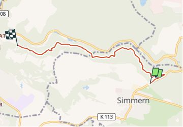
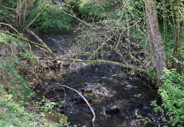
Trail On foot of 5 km to be discovered at Rhineland-Palatinate, Westerwaldkreis, Simmern. This trail is proposed by SityTrail - itinéraires balisés pédestres.

Description

Von Simmern (Friedhof) nach Vallendar (Schönstatt) am Hand des Hillscheider Bachtales über den Bollert und Schleifstein

Positioning

Country:
Germany
Region :
Rhineland-Palatinate
Department/Province :
Westerwaldkreis
Municipality :
Simmern
Location:
Unknown
Start:(UTM)
406103 ; 5583162 (32U) N.

Trails nearby

Trail On foot Urbar - Rheinsteig-Zuweg Immendorf/Arenberg - Photo
On foot
PRO

On foot

Easy
Urbar, Rhineland-Palatinate, Landkreis Mayen-Koblenz, Germany
6.3 km | 8.2 km-effort
1h 52min
No
Trail On foot  - Rheinsteig-Zuweg Arzheim - Photo
On foot
PRO

On foot

Easy
, Rhineland-Palatinate, Koblenz, Germany
3.5 km | 5.1 km-effort
1h 9min
No
Trail On foot  - Rheinsteig-Zuweg Asterstein - Photo
On foot
PRO

On foot

Easy
, Rhineland-Palatinate, Koblenz, Germany
3.3 km | 4.7 km-effort
1h 3min
No
Trail On foot Hillscheid - Köppelweg 1 - Photo
On foot
PRO

On foot

Easy
Hillscheid, Rhineland-Palatinate, Westerwaldkreis, Germany
11.3 km | 14.7 km-effort
3h 19min
No
Trail On foot Bad Ems - Wäller Tour Augst - Photo
On foot
PRO

On foot

Easy
Bad Ems, Rhineland-Palatinate, Rhein-Lahn-Kreis, Germany
13.7 km | 19.1 km-effort
4h 20min
Yes
Trail On foot Vallendar - Wanderweg 09 - Photo
On foot
PRO

On foot

Easy
Vallendar, Rhineland-Palatinate, Landkreis Mayen-Koblenz, Germany
8.5 km | 11.2 km-effort
2h 32min
Yes
Trail On foot Vallendar - Waldschluchtenweg - Photo
On foot
PRO

On foot

Easy
Vallendar, Rhineland-Palatinate, Landkreis Mayen-Koblenz, Germany
11.2 km | 15.7 km-effort
3h 34min
Yes
Trail On foot Simmern - Wanderweg 08 - Photo
On foot
PRO

On foot

Easy
Simmern, Rhineland-Palatinate, Westerwaldkreis, Germany
3.9 km | 4.6 km-effort
1h 3min
No
Trail On foot Vallendar - Rheinsteig - Etappe 9 [Vallendar - Koblenz-Ehrenbreitstein] - Photo
On foot
PRO

On foot

Easy
Vallendar, Rhineland-Palatinate, Landkreis Mayen-Koblenz, Germany
9.2 km | 12.4 km-effort
2h 49min
No


Close
My subscriptions