![](/images/other/stat-length.png)
![Trail On foot Altenberg - Rehefeld-Zinnwald - Photo](https://media.geolcdn.com/t/1900/400/ext.pjpeg?maxdim=2&url=https%3A%2F%2Fstatic1.geolcdn.com%2Fsiteimages%2Fupload%2Ffiles%2F1545311037marcheuse_200dpi.jpg)
Rehefeld-Zinnwald
SityTrail - itinéraires balisés pédestres
Tous les sentiers balisés d’Europe GUIDE+
![Length](/images/other/stat-length.png)
Length
4.1 km
![Max alt](https://static1.geolcdn.com/siteimages/upload/files/1508320355ic_sort_altitude_max_24dp.png)
Max alt
877 m
![Uphill gradient](https://static1.geolcdn.com/siteimages/upload/files/1508320355ic_sort_den_pos_24dp.png)
Uphill gradient
184 m
![Km-Effort](/images/other/stat-length.png)
Km-Effort
5.9 km
![Min alt](https://static1.geolcdn.com/siteimages/upload/files/1508320355ic_sort_altitude_min_24dp.png)
Min alt
695 m
![Downhill gradient](https://static1.geolcdn.com/siteimages/upload/files/1508320355ic_sort_den_neg_24dp.png)
Downhill gradient
6 m
![Boucle](https://static1.geolcdn.com/siteimages/upload/files/16400158638029165_repeat_loop_refresh_sync_direction_icon.png)
Boucle
No
Signpost
Creation date :
2022-02-21 08:14:51.186
Updated on :
2022-02-21 08:14:51.186
![On foot](https://static1.geolcdn.com/sitytour/trail-icons/100.png)
1h20
Difficulty : Easy
![Scan this QR Code to open this trail in the SityTrail application](https://capi.geolives.com/qq0zvz2zws4bq2lad0pu/sitytour/trails/3136350/qr.png?size=200)
FREE GPS app for hiking
About
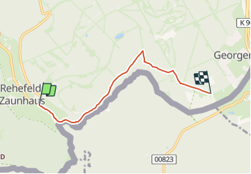
Trail On foot of 4.1 km to be discovered at Saxony, Sächsische Schweiz-Osterzgebirge, Altenberg. This trail is proposed by SityTrail - itinéraires balisés pédestres.
Description
Teilstück Schmiedeberg-Altenberg eigene Route
Symbol: Roter Strich auf weißem Grund
Positioning
Country:
Germany
Region :
Saxony
Department/Province :
Sächsische Schweiz-Osterzgebirge
Municipality :
Altenberg
Location:
Unknown
Start:(Dec)
Start:(UTM)
408513 ; 5620424 (33U) N.
Comments
Trails nearby
![Trail On foot Mikulov - Sklářská NS - Photo](https://media.geolcdn.com/t/375/260/b7c25c96-f53a-4e8a-b4e4-c4dbddd64bdc.jpeg&format=jpg&maxdim=2)
![On foot On foot](https://static1.geolcdn.com/sitytour/trail-icons/100.png)
Sklářská NS
On foot
Medium
Mikulov,
Northwest,
Ústecký kraj,
Czech Republic
![](/images/other/stat-length.png)
17.4 km | 21 km-effort
4h 51min
![](https://static1.geolcdn.com/siteimages/upload/files/16400158638029165_repeat_loop_refresh_sync_direction_icon.png)
Yes
![Trail On foot Dubí - [F] Dubský Cínovecký okruh - Photo](https://media.geolcdn.com/t/375/260/c6545c9b-76f0-4a2c-85bc-e7700ca98aca.jpeg&format=jpg&maxdim=2)
![On foot On foot](https://static1.geolcdn.com/sitytour/trail-icons/100.png)
[F] Dubský Cínovecký okruh
On foot
Easy
Dubí,
Northwest,
Ústecký kraj,
Czech Republic
![](/images/other/stat-length.png)
3.5 km | 4.3 km-effort
58min
![](https://static1.geolcdn.com/siteimages/upload/files/16400158638029165_repeat_loop_refresh_sync_direction_icon.png)
No
![Trail On foot Altenberg - Gelber Strich - Photo](https://media.geolcdn.com/t/375/260/9aca3cbf-4c47-4a78-b06b-91c9dfbf19cb.jpeg&format=jpg&maxdim=2)
![On foot On foot](https://static1.geolcdn.com/sitytour/trail-icons/100.png)
Gelber Strich
On foot
Easy
Altenberg,
Saxony,
Sächsische Schweiz-Osterzgebirge,
Germany
![](/images/other/stat-length.png)
3.7 km | 4.2 km-effort
57min
![](https://static1.geolcdn.com/siteimages/upload/files/16400158638029165_repeat_loop_refresh_sync_direction_icon.png)
No
![Trail On foot Altenberg - DE-Muss noch aufgeteilt werden - Ort zu Ort - Photo](https://media.geolcdn.com/t/375/260/86439145-81f2-4303-9a21-9858bb72c906.jpeg&format=jpg&maxdim=2)
![On foot On foot](https://static1.geolcdn.com/sitytour/trail-icons/100.png)
DE-Muss noch aufgeteilt werden - Ort zu Ort
On foot
Easy
Altenberg,
Saxony,
Sächsische Schweiz-Osterzgebirge,
Germany
![](/images/other/stat-length.png)
3.3 km | 4.2 km-effort
57min
![](https://static1.geolcdn.com/siteimages/upload/files/16400158638029165_repeat_loop_refresh_sync_direction_icon.png)
No
![Trail On foot Altenberg - Schmiedeberg - Altenberg - Photo](https://media.geolcdn.com/t/375/260/ext.jpg?maxdim=2&url=https%3A%2F%2Fstatic1.geolcdn.com%2Fsiteimages%2Fupload%2Ffiles%2F1545311037marcheuse_200dpi.jpg)
![On foot On foot](https://static1.geolcdn.com/sitytour/trail-icons/100.png)
Schmiedeberg - Altenberg
On foot
Easy
Altenberg,
Saxony,
Sächsische Schweiz-Osterzgebirge,
Germany
![](/images/other/stat-length.png)
6.3 km | 7.8 km-effort
1h 46min
![](https://static1.geolcdn.com/siteimages/upload/files/16400158638029165_repeat_loop_refresh_sync_direction_icon.png)
No
![Trail On foot Altenberg - Rotmarkierter Wanderweg - Photo](https://media.geolcdn.com/t/375/260/ext.jpg?maxdim=2&url=https%3A%2F%2Fstatic1.geolcdn.com%2Fsiteimages%2Fupload%2Ffiles%2F1545311037marcheuse_200dpi.jpg)
![On foot On foot](https://static1.geolcdn.com/sitytour/trail-icons/100.png)
Rotmarkierter Wanderweg
On foot
Easy
Altenberg,
Saxony,
Sächsische Schweiz-Osterzgebirge,
Germany
![](/images/other/stat-length.png)
3.6 km | 4.8 km-effort
1h 5min
![](https://static1.geolcdn.com/siteimages/upload/files/16400158638029165_repeat_loop_refresh_sync_direction_icon.png)
No
![Trail On foot Hermsdorf/Erzgebirge - Ww Seyde-Neuhermsdorf - Photo](https://media.geolcdn.com/t/375/260/ext.jpg?maxdim=2&url=https%3A%2F%2Fstatic1.geolcdn.com%2Fsiteimages%2Fupload%2Ffiles%2F1545311037marcheuse_200dpi.jpg)
![On foot On foot](https://static1.geolcdn.com/sitytour/trail-icons/100.png)
Ww Seyde-Neuhermsdorf
On foot
Easy
Hermsdorf/Erzgebirge,
Saxony,
Sächsische Schweiz-Osterzgebirge,
Germany
![](/images/other/stat-length.png)
3.1 km | 3.7 km-effort
50min
![](https://static1.geolcdn.com/siteimages/upload/files/16400158638029165_repeat_loop_refresh_sync_direction_icon.png)
No
![Trail On foot Altenberg - Lehrpfad Nr. 6 - Photo](https://media.geolcdn.com/t/375/260/ext.jpg?maxdim=2&url=https%3A%2F%2Fstatic1.geolcdn.com%2Fsiteimages%2Fupload%2Ffiles%2F1545311037marcheuse_200dpi.jpg)
![On foot On foot](https://static1.geolcdn.com/sitytour/trail-icons/100.png)
Lehrpfad Nr. 6
On foot
Easy
Altenberg,
Saxony,
Sächsische Schweiz-Osterzgebirge,
Germany
![](/images/other/stat-length.png)
3.3 km | 4 km-effort
54min
![](https://static1.geolcdn.com/siteimages/upload/files/16400158638029165_repeat_loop_refresh_sync_direction_icon.png)
No