![](/images/other/stat-length.png)
![Trail Walking Peyrolles-en-Provence - Peyrolles - Loubatas - Montauban - Photo](https://media.geolcdn.com/t/1900/400/ext.pjpeg?maxdim=2&url=https%3A%2F%2Fstatic1.geolcdn.com%2Fsiteimages%2Fupload%2Ffiles%2F1553511878bg_sport_marche.png)
Peyrolles - Loubatas - Montauban
Berpav
User
![Length](/images/other/stat-length.png)
Length
14.2 km
![Max alt](https://static1.geolcdn.com/siteimages/upload/files/1508320355ic_sort_altitude_max_24dp.png)
Max alt
513 m
![Uphill gradient](https://static1.geolcdn.com/siteimages/upload/files/1508320355ic_sort_den_pos_24dp.png)
Uphill gradient
342 m
![Km-Effort](/images/other/stat-length.png)
Km-Effort
18.7 km
![Min alt](https://static1.geolcdn.com/siteimages/upload/files/1508320355ic_sort_altitude_min_24dp.png)
Min alt
250 m
![Downhill gradient](https://static1.geolcdn.com/siteimages/upload/files/1508320355ic_sort_den_neg_24dp.png)
Downhill gradient
342 m
![Boucle](https://static1.geolcdn.com/siteimages/upload/files/16400158638029165_repeat_loop_refresh_sync_direction_icon.png)
Boucle
Yes
Creation date :
2022-02-17 16:43:09.847
Updated on :
2022-02-17 16:46:33.147
![Walking](https://static1.geolcdn.com/sitytour/trail-icons/101.png)
4h15
Difficulty : Difficult
![Scan this QR Code to open this trail in the SityTrail application](https://capi.geolives.com/qq0zvz2zws4bq2lad0pu/sitytour/trails/3132248/qr.png?size=200)
FREE GPS app for hiking
About
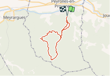
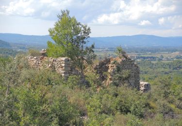
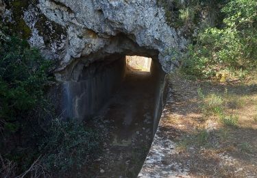
Trail Walking of 14.2 km to be discovered at Provence-Alpes-Côte d'Azur, Bouches-du-Rhône, Peyrolles-en-Provence. This trail is proposed by Berpav.
Description
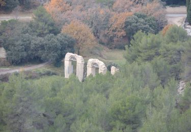
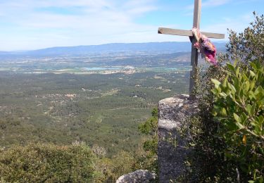
Par chemin découvertes, canal du Verdon et camp chinois. Retour par vallons de Montauban, de Loubatas et Corneroi.
Positioning
Country:
France
Region :
Provence-Alpes-Côte d'Azur
Department/Province :
Bouches-du-Rhône
Municipality :
Peyrolles-en-Provence
Location:
Unknown
Start:(Dec)
Start:(UTM)
708778 ; 4834749 (31T) N.
Comments
Trails nearby
![Trail On foot Jouques - Chapelle Notre-Dame-de-Consolation - Photo](https://media.geolcdn.com/t/375/260/ext.jpg?maxdim=2&url=https%3A%2F%2Fmedia.geolcdn.com%2Ff%2F5ed07bba-6b16-40be-8d98-5fc76334a463.jpeg)
![On foot On foot](https://static1.geolcdn.com/sitytour/trail-icons/100.png)
Chapelle Notre-Dame-de-Consolation
On foot
Easy
Jouques,
Provence-Alpes-Côte d'Azur,
Bouches-du-Rhône,
France
![](/images/other/stat-length.png)
5.1 km | 7.4 km-effort
1h 40min
![](https://static1.geolcdn.com/siteimages/upload/files/16400158638029165_repeat_loop_refresh_sync_direction_icon.png)
No
![Trail Walking Meyrargues - Meyrargue Camp chinois Vallon du petit - Photo](https://media.geolcdn.com/t/375/260/ext.jpg?maxdim=2&url=https%3A%2F%2Fmedia.geolcdn.com%2Ff%2Fbdb76f07-312d-4412-8213-94a98c001771.jpg)
![Walking Walking](https://static1.geolcdn.com/sitytour/trail-icons/101.png)
Meyrargue Camp chinois Vallon du petit
Walking
Medium
Meyrargues,
Provence-Alpes-Côte d'Azur,
Bouches-du-Rhône,
France
![](/images/other/stat-length.png)
11.4 km | 17 km-effort
4h 2min
![](https://static1.geolcdn.com/siteimages/upload/files/16400158638029165_repeat_loop_refresh_sync_direction_icon.png)
Yes
![Trail Walking Peyrolles-en-Provence - la trempasse - Photo](https://media.geolcdn.com/t/375/260/ext.jpg?maxdim=2&url=https%3A%2F%2Fmedia.geolcdn.com%2Ff%2Fe81bfe05-4381-4fe4-ad99-dbec04ae9128.jpg)
![Walking Walking](https://static1.geolcdn.com/sitytour/trail-icons/101.png)
la trempasse
Walking
Medium
Peyrolles-en-Provence,
Provence-Alpes-Côte d'Azur,
Bouches-du-Rhône,
France
![](/images/other/stat-length.png)
10.4 km | 16.3 km-effort
3h 49min
![](https://static1.geolcdn.com/siteimages/upload/files/16400158638029165_repeat_loop_refresh_sync_direction_icon.png)
Yes
![Trail Walking Jouques - Chapelle Notre Dame de Consolation - Photo](https://media.geolcdn.com/t/375/260/ext.jpg?maxdim=2&url=https%3A%2F%2Fmedia.geolcdn.com%2Ff%2F3df50e9f-951f-4f08-976d-e9661022c65d.jpg)
![Walking Walking](https://static1.geolcdn.com/sitytour/trail-icons/101.png)
Chapelle Notre Dame de Consolation
Walking
Medium
Jouques,
Provence-Alpes-Côte d'Azur,
Bouches-du-Rhône,
France
![](/images/other/stat-length.png)
9.7 km | 13 km-effort
3h 6min
![](https://static1.geolcdn.com/siteimages/upload/files/16400158638029165_repeat_loop_refresh_sync_direction_icon.png)
Yes
![Trail Walking Peyrolles-en-Provence - GB tour du lac de Peyrolles - Photo](https://media.geolcdn.com/t/375/260/ext.jpg?maxdim=2&url=https%3A%2F%2Fmedia.geolcdn.com%2Ff%2F381ba9ac-e329-4938-bd49-a7599c9fa710.jpg)
![Walking Walking](https://static1.geolcdn.com/sitytour/trail-icons/101.png)
GB tour du lac de Peyrolles
Walking
Easy
(1)
Peyrolles-en-Provence,
Provence-Alpes-Côte d'Azur,
Bouches-du-Rhône,
France
![](/images/other/stat-length.png)
3.8 km | 4.2 km-effort
1h 23min
![](https://static1.geolcdn.com/siteimages/upload/files/16400158638029165_repeat_loop_refresh_sync_direction_icon.png)
No
![Trail Walking Peyrolles-en-Provence - loubatas-Camp Chinois-retour par les vallons - Photo](https://media.geolcdn.com/t/375/260/ext.jpg?maxdim=2&url=https%3A%2F%2Fmedia.geolcdn.com%2Ff%2Feef47ac4-c641-43d2-bb84-26631de69203.jpg)
![Walking Walking](https://static1.geolcdn.com/sitytour/trail-icons/101.png)
loubatas-Camp Chinois-retour par les vallons
Walking
Very difficult
(2)
Peyrolles-en-Provence,
Provence-Alpes-Côte d'Azur,
Bouches-du-Rhône,
France
![](/images/other/stat-length.png)
15.3 km | 20 km-effort
3h 23min
![](https://static1.geolcdn.com/siteimages/upload/files/16400158638029165_repeat_loop_refresh_sync_direction_icon.png)
Yes
![Trail Walking Jouques - le concors - Photo](https://media.geolcdn.com/t/375/260/ext.jpg?maxdim=2&url=https%3A%2F%2Fservices.sitytrail.com%2FGeolivesWS%2FDownloadMedia.ashx%3FTrailID%3D230681%26Media%3D20131103131729.jpg)
![Walking Walking](https://static1.geolcdn.com/sitytour/trail-icons/101.png)
le concors
Walking
Easy
Jouques,
Provence-Alpes-Côte d'Azur,
Bouches-du-Rhône,
France
![](/images/other/stat-length.png)
9.6 km | 14.4 km-effort
2h 20min
![](https://static1.geolcdn.com/siteimages/upload/files/16400158638029165_repeat_loop_refresh_sync_direction_icon.png)
Yes
![Trail Walking Meyrargues - PF-Meyrargues - Les Calanques - Photo](https://media.geolcdn.com/t/375/260/ext.jpg?maxdim=2&url=https%3A%2F%2Fmedia.geolcdn.com%2Ff%2F6d9fdfec-1b13-4a7b-bf4c-46ead2c525dd.JPG)
![Walking Walking](https://static1.geolcdn.com/sitytour/trail-icons/101.png)
PF-Meyrargues - Les Calanques
Walking
Easy
Meyrargues,
Provence-Alpes-Côte d'Azur,
Bouches-du-Rhône,
France
![](/images/other/stat-length.png)
14 km | 20 km-effort
4h 11min
![](https://static1.geolcdn.com/siteimages/upload/files/16400158638029165_repeat_loop_refresh_sync_direction_icon.png)
Yes
![Trail Walking Peyrolles-en-Provence - la tempasse - Photo](https://media.geolcdn.com/t/375/260/ext.jpg?maxdim=2&url=https%3A%2F%2Fmedia.geolcdn.com%2Ff%2F253441c1-cd24-4537-b6b4-638da0c1444f.jpg)
![Walking Walking](https://static1.geolcdn.com/sitytour/trail-icons/101.png)
la tempasse
Walking
Medium
Peyrolles-en-Provence,
Provence-Alpes-Côte d'Azur,
Bouches-du-Rhône,
France
![](/images/other/stat-length.png)
10.3 km | 16.1 km-effort
3h 14min
![](https://static1.geolcdn.com/siteimages/upload/files/16400158638029165_repeat_loop_refresh_sync_direction_icon.png)
Yes
super