![](/images/other/stat-length.png)
![Trail On foot Hugleville-en-Caux - Le Bois de Grofys - Photo](https://media.geolcdn.com/t/1900/400/ext.pjpeg?maxdim=2&url=https%3A%2F%2Fstatic1.geolcdn.com%2Fsiteimages%2Fupload%2Ffiles%2F1545311037marcheuse_200dpi.jpg)
Le Bois de Grofys
SityTrail - itinéraires balisés pédestres
Tous les sentiers balisés d’Europe GUIDE+
![Length](/images/other/stat-length.png)
Length
11.6 km
![Max alt](https://static1.geolcdn.com/siteimages/upload/files/1508320355ic_sort_altitude_max_24dp.png)
Max alt
174 m
![Uphill gradient](https://static1.geolcdn.com/siteimages/upload/files/1508320355ic_sort_den_pos_24dp.png)
Uphill gradient
126 m
![Km-Effort](/images/other/stat-length.png)
Km-Effort
13.3 km
![Min alt](https://static1.geolcdn.com/siteimages/upload/files/1508320355ic_sort_altitude_min_24dp.png)
Min alt
131 m
![Downhill gradient](https://static1.geolcdn.com/siteimages/upload/files/1508320355ic_sort_den_neg_24dp.png)
Downhill gradient
122 m
![Boucle](https://static1.geolcdn.com/siteimages/upload/files/16400158638029165_repeat_loop_refresh_sync_direction_icon.png)
Boucle
Yes
Signpost
Creation date :
2022-02-17 11:06:04.894
Updated on :
2022-03-03 23:24:45.151
![On foot](https://static1.geolcdn.com/sitytour/trail-icons/100.png)
3h01
Difficulty : Easy
![Scan this QR Code to open this trail in the SityTrail application](https://capi.geolives.com/qq0zvz2zws4bq2lad0pu/sitytour/trails/3131305/qr.png?size=200)
FREE GPS app for hiking
About
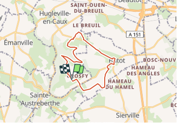
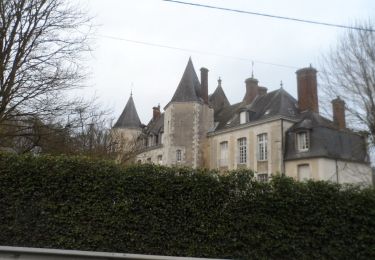
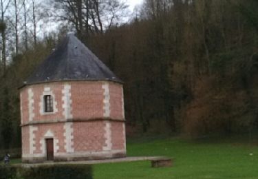
Trail On foot of 11.6 km to be discovered at Normandy, Seine-Maritime, Hugleville-en-Caux. This trail is proposed by SityTrail - itinéraires balisés pédestres.
Description
Trail created by Communauté de communes d'Yerville - Plateau de Caux.
Positioning
Country:
France
Region :
Normandy
Department/Province :
Seine-Maritime
Municipality :
Hugleville-en-Caux
Location:
Unknown
Start:(Dec)
Start:(UTM)
355287 ; 5496731 (31U) N.
Comments
Trails nearby
![Trail Walking Pavilly - 076-90-Pavilly / St Autreberthe 13.5km - Photo](https://media.geolcdn.com/t/375/260/a210e569-e658-42b2-bef9-eb8848a71140.jpg&format=jpg&maxdim=2)
![Walking Walking](https://static1.geolcdn.com/sitytour/trail-icons/101.png)
076-90-Pavilly / St Autreberthe 13.5km
Walking
Medium
(1)
Pavilly,
Normandy,
Seine-Maritime,
France
![](/images/other/stat-length.png)
12 km | 15 km-effort
3h 23min
![](https://static1.geolcdn.com/siteimages/upload/files/16400158638029165_repeat_loop_refresh_sync_direction_icon.png)
Yes
![Walking Walking](https://static1.geolcdn.com/sitytour/trail-icons/101.png)
20220203-Pavilly
Walking
Medium
Pavilly,
Normandy,
Seine-Maritime,
France
![](/images/other/stat-length.png)
12.1 km | 15 km-effort
3h 36min
![](https://static1.geolcdn.com/siteimages/upload/files/16400158638029165_repeat_loop_refresh_sync_direction_icon.png)
Yes
![Trail Walking Butot - Butot -76- Chemin de randonnée le BOis de Grosfy - Photo](https://media.geolcdn.com/t/375/260/f0adff7e-0510-443c-91e0-549769fd08c0.jpg&format=jpg&maxdim=2)
![Walking Walking](https://static1.geolcdn.com/sitytour/trail-icons/101.png)
Butot -76- Chemin de randonnée le BOis de Grosfy
Walking
Difficult
Butot,
Normandy,
Seine-Maritime,
France
![](/images/other/stat-length.png)
14.5 km | 16.7 km-effort
4h 3min
![](https://static1.geolcdn.com/siteimages/upload/files/16400158638029165_repeat_loop_refresh_sync_direction_icon.png)
Yes
![Trail Walking Pavilly - Pavilly St. Austreberthe (51) - Photo](https://media.geolcdn.com/t/375/260/ext.jpg?maxdim=2&url=https%3A%2F%2Fstatic1.geolcdn.com%2Fsiteimages%2Fupload%2Ffiles%2F1553511878bg_sport_marche.png)
![Walking Walking](https://static1.geolcdn.com/sitytour/trail-icons/101.png)
Pavilly St. Austreberthe (51)
Walking
Easy
(2)
Pavilly,
Normandy,
Seine-Maritime,
France
![](/images/other/stat-length.png)
10.3 km | 13 km-effort
2h 49min
![](https://static1.geolcdn.com/siteimages/upload/files/16400158638029165_repeat_loop_refresh_sync_direction_icon.png)
Yes
![Trail Walking Goupillières - Goupillieres 6 - Photo](https://media.geolcdn.com/t/375/260/d20b3b5a-9e1f-403e-b83f-9397a3ba6e1b.jpg&format=jpg&maxdim=2)
![Walking Walking](https://static1.geolcdn.com/sitytour/trail-icons/101.png)
Goupillieres 6
Walking
Easy
Goupillières,
Normandy,
Seine-Maritime,
France
![](/images/other/stat-length.png)
6.8 km | 7.6 km-effort
1h 40min
![](https://static1.geolcdn.com/siteimages/upload/files/16400158638029165_repeat_loop_refresh_sync_direction_icon.png)
Yes
![Trail On foot Pavilly - 2020-01-22_15h00m10_20200125-pavilly - Photo](https://media.geolcdn.com/t/375/260/fca199ec-9bf4-4b5c-87b4-2fd7de5421ae.jpg&format=jpg&maxdim=2)
![On foot On foot](https://static1.geolcdn.com/sitytour/trail-icons/100.png)
2020-01-22_15h00m10_20200125-pavilly
On foot
Very easy
Pavilly,
Normandy,
Seine-Maritime,
France
![](/images/other/stat-length.png)
13 km | 16 km-effort
Unknown
![](https://static1.geolcdn.com/siteimages/upload/files/16400158638029165_repeat_loop_refresh_sync_direction_icon.png)
Yes
![Trail Walking Sainte-Austreberthe - Ste Austreberthe Pavilly A-R - Photo](https://media.geolcdn.com/t/375/260/ext.jpg?maxdim=2&url=https%3A%2F%2Fservices.sitytrail.com%2FGeolivesWS%2FDownloadMedia.ashx%3FTrailID%3D908132%26Media%3Dfix__20180218155800.jpg)
![Walking Walking](https://static1.geolcdn.com/sitytour/trail-icons/101.png)
Ste Austreberthe Pavilly A-R
Walking
Difficult
Sainte-Austreberthe,
Normandy,
Seine-Maritime,
France
![](/images/other/stat-length.png)
12.5 km | 15.6 km-effort
3h 7min
![](https://static1.geolcdn.com/siteimages/upload/files/16400158638029165_repeat_loop_refresh_sync_direction_icon.png)
Yes
![Trail Walking Pavilly - 076-89-Pavilly Ste Austreberthe route du Lin 11km-877-716- - Photo](https://media.geolcdn.com/t/375/260/67b859b5-ac7f-468e-ba6f-19151b8fc1e7.jpg&format=jpg&maxdim=2)
![Walking Walking](https://static1.geolcdn.com/sitytour/trail-icons/101.png)
076-89-Pavilly Ste Austreberthe route du Lin 11km-877-716-
Walking
Easy
Pavilly,
Normandy,
Seine-Maritime,
France
![](/images/other/stat-length.png)
11 km | 13.7 km-effort
2h 56min
![](https://static1.geolcdn.com/siteimages/upload/files/16400158638029165_repeat_loop_refresh_sync_direction_icon.png)
Yes
![Trail Walking Fresquiennes - fresquennes - Photo](https://media.geolcdn.com/t/375/260/ext.jpg?maxdim=2&url=https%3A%2F%2Fstatic1.geolcdn.com%2Fsiteimages%2Fupload%2Ffiles%2F1553511878bg_sport_marche.png)
![Walking Walking](https://static1.geolcdn.com/sitytour/trail-icons/101.png)
fresquennes
Walking
Medium
(1)
Fresquiennes,
Normandy,
Seine-Maritime,
France
![](/images/other/stat-length.png)
10.2 km | 11.6 km-effort
2h 38min
![](https://static1.geolcdn.com/siteimages/upload/files/16400158638029165_repeat_loop_refresh_sync_direction_icon.png)
Yes