![](/images/other/stat-length.png)
![Trail On foot Unknown - Pętla Widzieńska - Photo](https://media.geolcdn.com/t/1900/400/ext.pjpeg?maxdim=2&url=https%3A%2F%2Fmedia.geolcdn.com%2Ff%2Fe239dee8-f289-4348-b9db-0bce9861733b.jpeg)
Pętla Widzieńska
SityTrail - itinéraires balisés pédestres
Tous les sentiers balisés d’Europe PRO
![Length](/images/other/stat-length.png)
Length
7.3 km
![Max alt](https://static1.geolcdn.com/siteimages/upload/files/1508320355ic_sort_altitude_max_24dp.png)
Max alt
36 m
![Uphill gradient](https://static1.geolcdn.com/siteimages/upload/files/1508320355ic_sort_den_pos_24dp.png)
Uphill gradient
91 m
![Km-Effort](/images/other/stat-length.png)
Km-Effort
8.6 km
![Min alt](https://static1.geolcdn.com/siteimages/upload/files/1508320355ic_sort_altitude_min_24dp.png)
Min alt
14 m
![Downhill gradient](https://static1.geolcdn.com/siteimages/upload/files/1508320355ic_sort_den_neg_24dp.png)
Downhill gradient
92 m
![Boucle](https://static1.geolcdn.com/siteimages/upload/files/16400158638029165_repeat_loop_refresh_sync_direction_icon.png)
Boucle
Yes
Signpost
Creation date :
2022-02-16 17:33:52.181
Updated on :
2022-03-08 14:59:38.111
![On foot](https://static1.geolcdn.com/sitytour/trail-icons/100.png)
1h56
Difficulty : Easy
![Scan this QR Code to open this trail in the SityTrail application](https://capi.geolives.com/qq0zvz2zws4bq2lad0pu/sitytour/trails/3129928/qr.png?size=200)
FREE GPS app for hiking
About
Trail On foot of 7.3 km to be discovered at West Pomeranian Voivodeship, Goleniów County. This trail is proposed by SityTrail - itinéraires balisés pédestres.
Description
Symbol: niebieski pasek
Website: http://szlaki-zachodniopomorskie.pl/articles.php?article_id=159
Positioning
Country:
Poland
Region :
West Pomeranian Voivodeship
Department/Province :
Goleniów County
Municipality :
Unknown
Location:
Unknown
Start:(Dec)
Start:(UTM)
483359 ; 5946199 (33U) N.
Comments
Trails nearby
![Trail On foot - Szlak](https://media.geolcdn.com/t/375/260/ext.jpg?maxdim=2&url=https%3A%2F%2Fmedia.geolcdn.com%2Ff%2F0f798efe-d89a-41db-b217-282c02e00928.jpeg)
![On foot On foot](https://static1.geolcdn.com/sitytour/trail-icons/100.png)
Szlak "Doliną Gowienicy"
On foot
Easy
,
West Pomeranian Voivodeship,
Goleniów County,
Poland
![](/images/other/stat-length.png)
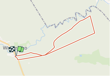
15 km | 16.7 km-effort
3h 47min
![](https://static1.geolcdn.com/siteimages/upload/files/16400158638029165_repeat_loop_refresh_sync_direction_icon.png)
Yes