Trail On foot Bad Hindelang - Grenzgänger - Photo

Tous les sentiers balisés d’Europe GUIDE+

© OpenStreetMap contributors
Length
Length
30 km
Max alt
Max alt
2175 m
Uphill gradient
Uphill gradient
2247 m
Km-Effort
Km-Effort  
63 km
Min alt
Min alt
1062 m
Downhill gradient
Downhill gradient
3023 m
Boucle
Boucle
No
Signpost
Signpost
Creation date :
2022-02-16 17:33:33.422
Updated on :
2022-02-16 17:33:33.422

(0 Reviews)

On foot
On foot
14h14
Difficulty : Very difficult

Scan this QR Code to open this trail in the SityTrail application

FREE GPS app for hiking

Logo SityTrail SityTrail

IGN / Geographical institutes

Download SityTrail from the App Store Download SityTrail from Google Play

Logo SityTrail SityTrail World

The world is yours!

Download SityTrail from the App Store Download SityTrail from Google Play Download SityTrail on Huawei AppGallery

About

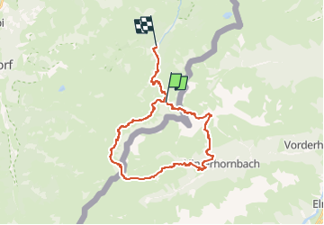
Trail On foot of 30 km to be discovered at Bavaria, Landkreis Oberallgäu, Bad Hindelang. This trail is proposed by SityTrail - itinéraires balisés pédestres.

Description

Beim »Grenzgänger« handelt es sich um eine Mehrtagestour inmitten der Allgäuer Alpen

Website: https://www.grenzgaenger-wandern.com/

Elevation profile

Photos

Positioning

Country:
Germany
Region :
Bavaria
Department/Province :
Landkreis Oberallgäu
Municipality :
Bad Hindelang
Location:
Unknown
Start:(UTM)
607113 ; 5249745 (32T) N.

Trails nearby

Trail On foot Gemeinde Hinterhornbach - Nederpfad - Photo
On foot
GUIDE+

On foot

Easy
Gemeinde Hinterhornbach, Tyrol, Bezirk Reutte, Austria
4 km | 7.3 km-effort
1h 39min
No
Trail On foot Gemeinde Hinterhornbach - Kanzbergweg - Photo
On foot
GUIDE+

On foot

Easy
Gemeinde Hinterhornbach, Tyrol, Bezirk Reutte, Austria
6 km | 16.4 km-effort
3h 43min
No


Close
My subscriptions