


Szlak Bunkrów

SityTrail - itinéraires balisés pédestres
Tous les sentiers balisés d’Europe GUIDE+

Length
12.8 km

Max alt
172 m

Uphill gradient
128 m
Km-Effort
14.5 km

Min alt
118 m

Downhill gradient
120 m
Boucle
No

Signpost
Creation date :
2022-02-16 17:32:14.49
Updated on :
2022-03-08 14:55:05.169
3h17
Difficulty : Easy

FREE GPS app for hiking
 SityTrail
IGN / Geographical institutes
SityTrail World
The world is yours!
About
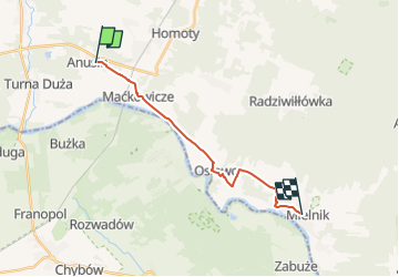
Trail On foot of 12.8 km to be discovered at Podlaskie Voivodeship, Siemiatycze County, Anusin. This trail is proposed by SityTrail - itinéraires balisés pédestres.
Description
Trail created by PTTK.
Symbol: blue
Photos


Positioning
Country:
Poland
Region :
Podlaskie Voivodeship
Department/Province :
Siemiatycze County
Municipality :
Anusin
Location:
Unknown
Start:(Dec)
Start:(UTM)
630497 ; 5805985 (34U) N.
Comments
Trails nearby