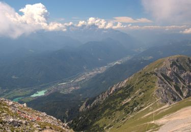
![](/images/other/stat-length.png)
![Trail On foot Ferlach - Sinacher Gupf-Runde - Photo](https://media.geolcdn.com/t/1900/400/ext.pjpeg?maxdim=2&url=https%3A%2F%2Fmedia.geolcdn.com%2Ff%2F5931ca75-bb44-4ee2-a568-832de664fe2d.jpeg)
Sinacher Gupf-Runde
SityTrail - itinéraires balisés pédestres
Tous les sentiers balisés d’Europe PRO
![Length](/images/other/stat-length.png)
Length
6.2 km
![Max alt](https://static1.geolcdn.com/siteimages/upload/files/1508320355ic_sort_altitude_max_24dp.png)
Max alt
1129 m
![Uphill gradient](https://static1.geolcdn.com/siteimages/upload/files/1508320355ic_sort_den_pos_24dp.png)
Uphill gradient
85 m
![Km-Effort](/images/other/stat-length.png)
Km-Effort
8.8 km
![Min alt](https://static1.geolcdn.com/siteimages/upload/files/1508320355ic_sort_altitude_min_24dp.png)
Min alt
618 m
![Downhill gradient](https://static1.geolcdn.com/siteimages/upload/files/1508320355ic_sort_den_neg_24dp.png)
Downhill gradient
525 m
![Boucle](https://static1.geolcdn.com/siteimages/upload/files/16400158638029165_repeat_loop_refresh_sync_direction_icon.png)
Boucle
No
Signpost
Creation date :
2022-02-16 17:30:46.463
Updated on :
2022-03-03 21:14:11.153
![On foot](https://static1.geolcdn.com/sitytour/trail-icons/100.png)
1h59
Difficulty : Easy
![Scan this QR Code to open this trail in the SityTrail application](https://capi.geolives.com/qq0zvz2zws4bq2lad0pu/sitytour/trails/3129822/qr.png?size=200)
FREE GPS app for hiking
About
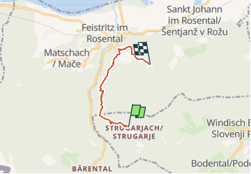
Trail On foot of 6.2 km to be discovered at Carinthia, Bezirk Klagenfurt-Land, Ferlach. This trail is proposed by SityTrail - itinéraires balisés pédestres.
Description
Trail created by ÖAV – Sektion Klagenfurt – Karawanken-Vorberge – Feistritz i. R. – Sinacher Gupf-Runde https://www.outdooractive.com/de/bergtour/feistritz-im-rosental/sinacher-gupf-runde/35963776/.
Positioning
Country:
Austria
Region :
Carinthia
Department/Province :
Bezirk Klagenfurt-Land
Municipality :
Ferlach
Location:
Unknown
Start:(Dec)
Start:(UTM)
437134 ; 5148933 (33T) N.
Comments
Trails nearby
![Trail On foot Feistritz im Rosental - Bärental-Hochstuhl-Runde - Photo](https://media.geolcdn.com/t/375/260/ext.jpg?maxdim=2&url=https%3A%2F%2Fmedia.geolcdn.com%2Ff%2Fc8c96e24-cb5e-42e5-8f75-0f310ce4860f.jpeg)
![On foot On foot](https://static1.geolcdn.com/sitytour/trail-icons/100.png)
Bärental-Hochstuhl-Runde
On foot
Medium
Feistritz im Rosental,
Carinthia,
Bezirk Klagenfurt-Land,
Austria
![](/images/other/stat-length.png)
9 km | 23 km-effort
5h 9min
![](https://static1.geolcdn.com/siteimages/upload/files/16400158638029165_repeat_loop_refresh_sync_direction_icon.png)
No
![Trail On foot Feistritz im Rosental - Matschacher Gupf-Runde - Photo](https://media.geolcdn.com/t/375/260/ext.jpg?maxdim=2&url=https%3A%2F%2Fmedia.geolcdn.com%2Ff%2F9b892da1-0482-49be-9515-dcaad1157c26.jpeg)
![On foot On foot](https://static1.geolcdn.com/sitytour/trail-icons/100.png)
Matschacher Gupf-Runde
On foot
Medium
Feistritz im Rosental,
Carinthia,
Bezirk Klagenfurt-Land,
Austria
![](/images/other/stat-length.png)
15.2 km | 30 km-effort
6h 44min
![](https://static1.geolcdn.com/siteimages/upload/files/16400158638029165_repeat_loop_refresh_sync_direction_icon.png)
Yes