![](/images/other/stat-length.png)
![Trail On foot Valsot - Sclamischot - Plan da la Scorza - Photo](https://media.geolcdn.com/t/1900/400/ext.pjpeg?maxdim=2&url=https%3A%2F%2Fstatic1.geolcdn.com%2Fsiteimages%2Fupload%2Ffiles%2F1545311037marcheuse_200dpi.jpg)
Sclamischot - Plan da la Scorza
SityTrail - itinéraires balisés pédestres
Tous les sentiers balisés d’Europe GUIDE+
![Length](/images/other/stat-length.png)
Length
6.1 km
![Max alt](https://static1.geolcdn.com/siteimages/upload/files/1508320355ic_sort_altitude_max_24dp.png)
Max alt
1553 m
![Uphill gradient](https://static1.geolcdn.com/siteimages/upload/files/1508320355ic_sort_den_pos_24dp.png)
Uphill gradient
532 m
![Km-Effort](/images/other/stat-length.png)
Km-Effort
11.6 km
![Min alt](https://static1.geolcdn.com/siteimages/upload/files/1508320355ic_sort_altitude_min_24dp.png)
Min alt
1039 m
![Downhill gradient](https://static1.geolcdn.com/siteimages/upload/files/1508320355ic_sort_den_neg_24dp.png)
Downhill gradient
48 m
![Boucle](https://static1.geolcdn.com/siteimages/upload/files/16400158638029165_repeat_loop_refresh_sync_direction_icon.png)
Boucle
No
Signpost
Creation date :
2022-02-16 17:20:58.746
Updated on :
2022-02-16 17:20:58.746
![On foot](https://static1.geolcdn.com/sitytour/trail-icons/100.png)
2h38
Difficulty : Easy
![Scan this QR Code to open this trail in the SityTrail application](https://capi.geolives.com/qq0zvz2zws4bq2lad0pu/sitytour/trails/3129454/qr.png?size=200)
FREE GPS app for hiking
About
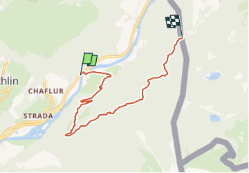
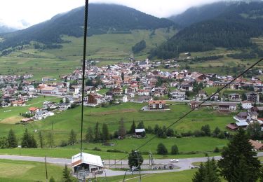
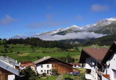
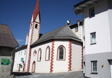
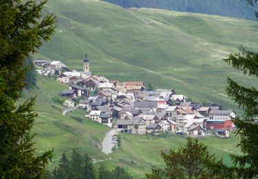
Trail On foot of 6.1 km to be discovered at Grisons, Region Engiadina Bassa/Val Müstair, Valsot. This trail is proposed by SityTrail - itinéraires balisés pédestres.
Description
Sclamischot - Plan da la Scorza
Symbol: weiss-rot-weiss
Positioning
Country:
Switzerland
Region :
Grisons
Department/Province :
Region Engiadina Bassa/Val Müstair
Municipality :
Valsot
Location:
Unknown
Start:(Dec)
Start:(UTM)
610122 ; 5191755 (32T) N.
Comments
Trails nearby
![Trail Other activity Valsot - bdr09_Martina_Truebbach - Photo](https://media.geolcdn.com/t/375/260/ext.jpg?maxdim=2&url=https%3A%2F%2Fstatic1.geolcdn.com%2Fsiteimages%2Fupload%2Ffiles%2F1545311037marcheuse_200dpi.jpg)
![Other activity Other activity](https://static1.geolcdn.com/sitytour/trail-icons/900.png)
bdr09_Martina_Truebbach
Other activity
Very easy
(1)
Valsot,
Grisons,
Region Engiadina Bassa/Val Müstair,
Switzerland
![](/images/other/stat-length.png)
138 km | 332 km-effort
Unknown
![](https://static1.geolcdn.com/siteimages/upload/files/16400158638029165_repeat_loop_refresh_sync_direction_icon.png)
No
![Trail On foot Valsot - Martina - Alp Tea - Photo](https://media.geolcdn.com/t/375/260/b80a892d-1ad2-4a1d-a196-1522f1d55134.jpeg&format=jpg&maxdim=2)
![On foot On foot](https://static1.geolcdn.com/sitytour/trail-icons/100.png)
Martina - Alp Tea
On foot
Easy
Valsot,
Grisons,
Region Engiadina Bassa/Val Müstair,
Switzerland
![](/images/other/stat-length.png)
9.2 km | 19.2 km-effort
4h 21min
![](https://static1.geolcdn.com/siteimages/upload/files/16400158638029165_repeat_loop_refresh_sync_direction_icon.png)
No
![Trail On foot Gemeinde Nauders - Nauders Wanderweg Nr. 5 - Photo](https://media.geolcdn.com/t/375/260/1b61f813-7e64-4ad6-94e0-88d197935934.jpeg&format=jpg&maxdim=2)
![On foot On foot](https://static1.geolcdn.com/sitytour/trail-icons/100.png)
Nauders Wanderweg Nr. 5
On foot
Easy
Gemeinde Nauders,
Tyrol,
Bezirk Landeck,
Austria
![](/images/other/stat-length.png)
3.2 km | 6.9 km-effort
1h 33min
![](https://static1.geolcdn.com/siteimages/upload/files/16400158638029165_repeat_loop_refresh_sync_direction_icon.png)
No
![Trail On foot Gemeinde Nauders - Nauders Wanderweg Nr. 17 - Photo](https://media.geolcdn.com/t/375/260/9bec7bdc-c4fa-49b9-a968-20ccbc626705.jpeg&format=jpg&maxdim=2)
![On foot On foot](https://static1.geolcdn.com/sitytour/trail-icons/100.png)
Nauders Wanderweg Nr. 17
On foot
Easy
Gemeinde Nauders,
Tyrol,
Bezirk Landeck,
Austria
![](/images/other/stat-length.png)
6.4 km | 15.4 km-effort
3h 30min
![](https://static1.geolcdn.com/siteimages/upload/files/16400158638029165_repeat_loop_refresh_sync_direction_icon.png)
No
![Trail On foot Gemeinde Nauders - Nauders Wanderweg Nr. 26 - Photo](https://media.geolcdn.com/t/375/260/c5c1f670-08bc-45f3-852e-25a5b13447a1.jpeg&format=jpg&maxdim=2)
![On foot On foot](https://static1.geolcdn.com/sitytour/trail-icons/100.png)
Nauders Wanderweg Nr. 26
On foot
Easy
Gemeinde Nauders,
Tyrol,
Bezirk Landeck,
Austria
![](/images/other/stat-length.png)
4.5 km | 11.1 km-effort
2h 30min
![](https://static1.geolcdn.com/siteimages/upload/files/16400158638029165_repeat_loop_refresh_sync_direction_icon.png)
No
![Trail On foot Gemeinde Nauders - Nauders Wanderweg Nr. 2 - Photo](https://media.geolcdn.com/t/375/260/7a554833-0b04-4979-9284-3cd3b7fe07b3.jpeg&format=jpg&maxdim=2)
![On foot On foot](https://static1.geolcdn.com/sitytour/trail-icons/100.png)
Nauders Wanderweg Nr. 2
On foot
Easy
Gemeinde Nauders,
Tyrol,
Bezirk Landeck,
Austria
![](/images/other/stat-length.png)
3.8 km | 7.4 km-effort
1h 41min
![](https://static1.geolcdn.com/siteimages/upload/files/16400158638029165_repeat_loop_refresh_sync_direction_icon.png)
No
![Trail On foot Valsot - Seraplana - Motta - Photo](https://media.geolcdn.com/t/375/260/50da0e36-5cca-4bf3-ac1f-a9ef811b000c.jpeg&format=jpg&maxdim=2)
![On foot On foot](https://static1.geolcdn.com/sitytour/trail-icons/100.png)
Seraplana - Motta
On foot
Easy
Valsot,
Grisons,
Region Engiadina Bassa/Val Müstair,
Switzerland
![](/images/other/stat-length.png)
3.9 km | 7.5 km-effort
1h 42min
![](https://static1.geolcdn.com/siteimages/upload/files/16400158638029165_repeat_loop_refresh_sync_direction_icon.png)
No
![Trail On foot Valsot - Chaflur - Martina - Photo](https://media.geolcdn.com/t/375/260/ext.jpg?maxdim=2&url=https%3A%2F%2Fstatic1.geolcdn.com%2Fsiteimages%2Fupload%2Ffiles%2F1545311037marcheuse_200dpi.jpg)
![On foot On foot](https://static1.geolcdn.com/sitytour/trail-icons/100.png)
Chaflur - Martina
On foot
Easy
Valsot,
Grisons,
Region Engiadina Bassa/Val Müstair,
Switzerland
![](/images/other/stat-length.png)
3.3 km | 4.6 km-effort
1h 2min
![](https://static1.geolcdn.com/siteimages/upload/files/16400158638029165_repeat_loop_refresh_sync_direction_icon.png)
No
![Trail On foot Valsot - Plajazan - Marangun - Photo](https://media.geolcdn.com/t/375/260/ext.jpg?maxdim=2&url=https%3A%2F%2Fstatic1.geolcdn.com%2Fsiteimages%2Fupload%2Ffiles%2F1545311037marcheuse_200dpi.jpg)
![On foot On foot](https://static1.geolcdn.com/sitytour/trail-icons/100.png)
Plajazan - Marangun
On foot
Easy
Valsot,
Grisons,
Region Engiadina Bassa/Val Müstair,
Switzerland
![](/images/other/stat-length.png)
4.2 km | 9.7 km-effort
2h 12min
![](https://static1.geolcdn.com/siteimages/upload/files/16400158638029165_repeat_loop_refresh_sync_direction_icon.png)
No