


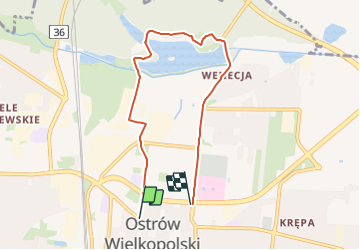
Ostrowska Trasa Turystyczna

SityTrail - itinéraires balisés pédestres
Tous les sentiers balisés d’Europe GUIDE+

Length
5.8 km

Max alt
136 m

Uphill gradient
39 m
Km-Effort
6.3 km

Min alt
124 m

Downhill gradient
40 m
Boucle
No

Signpost
Creation date :
2022-02-16 17:19:13.496
Updated on :
2022-03-08 14:12:37.461
1h25
Difficulty : Easy

FREE GPS app for hiking
 SityTrail
IGN / Geographical institutes
SityTrail World
The world is yours!
About
Trail On foot of 5.8 km to be discovered at Greater Poland Voivodeship, Ostrów Wielkopolski County. This trail is proposed by SityTrail - itinéraires balisés pédestres.
Description
Trail created by Punkt Informacji Turystycznej Ostrów Wielkopolski.
Photos


Positioning
Country:
Poland
Region :
Greater Poland Voivodeship
Department/Province :
Ostrów Wielkopolski County
Municipality :
Unknown
Location:
Unknown
Start:(Dec)
Start:(UTM)
694687 ; 5725995 (33U) N.
Comments
Trails nearby