![](/images/other/stat-length.png)
![Trail On foot Steyregg - Kreuzweg - Photo](https://media.geolcdn.com/t/1900/400/a6773d09-7bc7-4e11-8684-0795fb65f2d2.jpeg&format=pjpeg&maxdim=2)
Kreuzweg
SityTrail - itinéraires balisés pédestres
Tous les sentiers balisés d’Europe GUIDE+
![Length](/images/other/stat-length.png)
![Max alt](https://static1.geolcdn.com/siteimages/upload/files/1508320355ic_sort_altitude_max_24dp.png)
![Uphill gradient](https://static1.geolcdn.com/siteimages/upload/files/1508320355ic_sort_den_pos_24dp.png)
![Km-Effort](/images/other/stat-length.png)
![Min alt](https://static1.geolcdn.com/siteimages/upload/files/1508320355ic_sort_altitude_min_24dp.png)
![Downhill gradient](https://static1.geolcdn.com/siteimages/upload/files/1508320355ic_sort_den_neg_24dp.png)
![Boucle](https://static1.geolcdn.com/siteimages/upload/files/16400158638029165_repeat_loop_refresh_sync_direction_icon.png)
![On foot](https://static1.geolcdn.com/sitytour/trail-icons/100.png)
1h19
Difficulty : Easy
![Scan this QR Code to open this trail in the SityTrail application](https://capi.geolives.com/qq0zvz2zws4bq2lad0pu/sitytour/trails/3128667/qr.png?size=200)
FREE GPS app for hiking
About
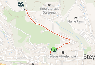
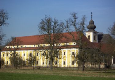
Trail On foot of 3 km to be discovered at Upper Austria, Bezirk Urfahr-Umgebung, Steyregg. This trail is proposed by SityTrail - itinéraires balisés pédestres.
Description
Täglich gehen wir Wege und Straßen, jahrein, jahraus. Wir laden Sie ein, in Steyregg den Weg zu gehen, Ruhe zu finden, um im Glauben zu Gott einen Schritt weiter zu kommen.
Website: https://www.dioezese-linz.at/pfarre/4412/pfarre/geschichte/kreuzweg
Positioning
Comments
Trails nearby
![Trail On foot Steyregg - 3 Buchen Weg - Photo](https://media.geolcdn.com/t/375/260/4bacca63-a8d1-45f1-ab57-007b5153619f.jpeg&format=jpg&maxdim=2)
![On foot On foot](https://static1.geolcdn.com/sitytour/trail-icons/100.png)
On foot
![](/images/other/stat-length.png)
![](https://static1.geolcdn.com/siteimages/upload/files/16400158638029165_repeat_loop_refresh_sync_direction_icon.png)
![Trail On foot Steyregg - Pfenningberg-Gipfelwanderweg - Photo](https://media.geolcdn.com/t/375/260/4bacca63-a8d1-45f1-ab57-007b5153619f.jpeg&format=jpg&maxdim=2)
![On foot On foot](https://static1.geolcdn.com/sitytour/trail-icons/100.png)
On foot
![](/images/other/stat-length.png)
![](https://static1.geolcdn.com/siteimages/upload/files/16400158638029165_repeat_loop_refresh_sync_direction_icon.png)
![Trail On foot Steyregg - AV 50 Daxleitner - Photo](https://media.geolcdn.com/t/375/260/ac8aab2e-87f4-4c25-ae1f-c0ffc1bf5d02.jpeg&format=jpg&maxdim=2)
![On foot On foot](https://static1.geolcdn.com/sitytour/trail-icons/100.png)
On foot
![](/images/other/stat-length.png)
![](https://static1.geolcdn.com/siteimages/upload/files/16400158638029165_repeat_loop_refresh_sync_direction_icon.png)
![Trail On foot Steyregg - Donau-Höhen-Rundwanderweg - Photo](https://media.geolcdn.com/t/375/260/8ac3dd22-caf0-4c74-be5d-1aa724a2aedc.jpeg&format=jpg&maxdim=2)
![On foot On foot](https://static1.geolcdn.com/sitytour/trail-icons/100.png)
On foot
![](/images/other/stat-length.png)
![](https://static1.geolcdn.com/siteimages/upload/files/16400158638029165_repeat_loop_refresh_sync_direction_icon.png)
![Trail On foot - Stadtwanderweg Ebelsberg - Weikerlsee - Photo](https://media.geolcdn.com/t/375/260/41042cda-531b-4711-87b8-c53cb0c68169.jpeg&format=jpg&maxdim=2)
![On foot On foot](https://static1.geolcdn.com/sitytour/trail-icons/100.png)
On foot
![](/images/other/stat-length.png)
![](https://static1.geolcdn.com/siteimages/upload/files/16400158638029165_repeat_loop_refresh_sync_direction_icon.png)
![Trail On foot Steyregg - Stadtwanderweg Pfenningberg - Photo](https://media.geolcdn.com/t/375/260/ac8aab2e-87f4-4c25-ae1f-c0ffc1bf5d02.jpeg&format=jpg&maxdim=2)
![On foot On foot](https://static1.geolcdn.com/sitytour/trail-icons/100.png)
On foot
![](/images/other/stat-length.png)
![](https://static1.geolcdn.com/siteimages/upload/files/16400158638029165_repeat_loop_refresh_sync_direction_icon.png)
![Trail On foot Steyregg - Stadtwanderweg Plesching - Photo](https://media.geolcdn.com/t/375/260/2cb10a17-9e4b-49b4-91b3-3a2e20f0f647.jpeg&format=jpg&maxdim=2)
![On foot On foot](https://static1.geolcdn.com/sitytour/trail-icons/100.png)
On foot
![](/images/other/stat-length.png)
![](https://static1.geolcdn.com/siteimages/upload/files/16400158638029165_repeat_loop_refresh_sync_direction_icon.png)
![Trail On foot Steyregg - Steyregger Runde - Photo](https://media.geolcdn.com/t/375/260/a6773d09-7bc7-4e11-8684-0795fb65f2d2.jpeg&format=jpg&maxdim=2)
![On foot On foot](https://static1.geolcdn.com/sitytour/trail-icons/100.png)
On foot
![](/images/other/stat-length.png)
![](https://static1.geolcdn.com/siteimages/upload/files/16400158638029165_repeat_loop_refresh_sync_direction_icon.png)
![Trail Bicycle tourism Luftenberg an der Donau - Line Grein - Photo](https://media.geolcdn.com/t/375/260/ext.jpg?maxdim=2&url=https%3A%2F%2Fstatic1.geolcdn.com%2Fsiteimages%2Fupload%2Ffiles%2F1524743154velo.jpg)
![Bicycle tourism Bicycle tourism](https://static1.geolcdn.com/sitytour/trail-icons/204.png)
Bicycle tourism
![](/images/other/stat-length.png)
![](https://static1.geolcdn.com/siteimages/upload/files/16400158638029165_repeat_loop_refresh_sync_direction_icon.png)