![](/images/other/stat-length.png)
![Trail On foot Rainbach im Mühlkreis - Weg der Farben - Photo](https://media.geolcdn.com/t/1900/400/668734bc-f752-42ca-b920-7926c11738e2.jpeg&format=pjpeg&maxdim=2)
Weg der Farben
SityTrail - itinéraires balisés pédestres
Tous les sentiers balisés d’Europe GUIDE+
![Length](/images/other/stat-length.png)
Length
4.7 km
![Max alt](https://static1.geolcdn.com/siteimages/upload/files/1508320355ic_sort_altitude_max_24dp.png)
Max alt
716 m
![Uphill gradient](https://static1.geolcdn.com/siteimages/upload/files/1508320355ic_sort_den_pos_24dp.png)
Uphill gradient
62 m
![Km-Effort](/images/other/stat-length.png)
Km-Effort
5.5 km
![Min alt](https://static1.geolcdn.com/siteimages/upload/files/1508320355ic_sort_altitude_min_24dp.png)
Min alt
667 m
![Downhill gradient](https://static1.geolcdn.com/siteimages/upload/files/1508320355ic_sort_den_neg_24dp.png)
Downhill gradient
63 m
![Boucle](https://static1.geolcdn.com/siteimages/upload/files/16400158638029165_repeat_loop_refresh_sync_direction_icon.png)
Boucle
Yes
Signpost
Creation date :
2022-02-16 17:02:10.388
Updated on :
2022-03-03 15:47:24.356
![On foot](https://static1.geolcdn.com/sitytour/trail-icons/100.png)
1h14
Difficulty : Easy
![Scan this QR Code to open this trail in the SityTrail application](https://capi.geolives.com/qq0zvz2zws4bq2lad0pu/sitytour/trails/3128650/qr.png?size=200)
FREE GPS app for hiking
About
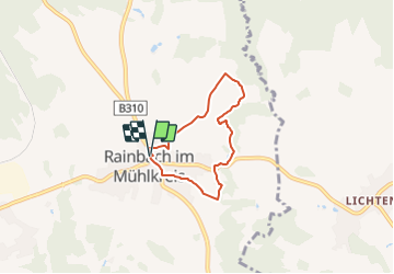
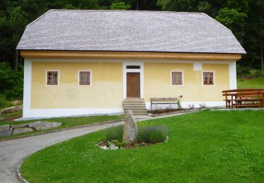
Trail On foot of 4.7 km to be discovered at Upper Austria, Bezirk Freistadt, Rainbach im Mühlkreis. This trail is proposed by SityTrail - itinéraires balisés pédestres.
Description
Trail created by Tourismuskern Rainbach.
Positioning
Country:
Austria
Region :
Upper Austria
Department/Province :
Bezirk Freistadt
Municipality :
Rainbach im Mühlkreis
Location:
Unknown
Start:(Dec)
Start:(UTM)
461392 ; 5378524 (33U) N.
Comments
Trails nearby
![Trail On foot Lipno nad Vltavou - NS Lipno - Photo](https://media.geolcdn.com/t/375/260/bca64c7f-4c7e-4dd8-b026-404e5db5ccbf.jpeg&format=jpg&maxdim=2)
![On foot On foot](https://static1.geolcdn.com/sitytour/trail-icons/100.png)
NS Lipno
On foot
Easy
Lipno nad Vltavou,
Southwest,
Jihočeský kraj,
Czech Republic
![](/images/other/stat-length.png)
6.8 km | 9.8 km-effort
2h 14min
![](https://static1.geolcdn.com/siteimages/upload/files/16400158638029165_repeat_loop_refresh_sync_direction_icon.png)
No
![Trail On foot Dolní Dvořiště - NS Řemeslo na řece - Photo](https://media.geolcdn.com/t/375/260/a376140f-937a-4ed3-ac84-99fe746f1d4f.jpeg&format=jpg&maxdim=2)
![On foot On foot](https://static1.geolcdn.com/sitytour/trail-icons/100.png)
NS Řemeslo na řece
On foot
Easy
Dolní Dvořiště,
Southwest,
Jihočeský kraj,
Czech Republic
![](/images/other/stat-length.png)
14.8 km | 18.8 km-effort
4h 15min
![](https://static1.geolcdn.com/siteimages/upload/files/16400158638029165_repeat_loop_refresh_sync_direction_icon.png)
No
![Trail On foot Horní Stropnice - [Č] Okruh Vysoká - Photo](https://media.geolcdn.com/t/375/260/51f9414b-801b-4b25-85ad-de34c547ba6c.jpeg&format=jpg&maxdim=2)
![On foot On foot](https://static1.geolcdn.com/sitytour/trail-icons/100.png)
[Č] Okruh Vysoká
On foot
Easy
Horní Stropnice,
Southwest,
Jihočeský kraj,
Czech Republic
![](/images/other/stat-length.png)
8 km | 11.3 km-effort
2h 33min
![](https://static1.geolcdn.com/siteimages/upload/files/16400158638029165_repeat_loop_refresh_sync_direction_icon.png)
No
![Trail On foot Loučovice - [Ž] Kapličky - Mnichovice - Photo](https://media.geolcdn.com/t/375/260/1772f7d3-364c-4f12-bb68-2d31ffa4b776.jpeg&format=jpg&maxdim=2)
![On foot On foot](https://static1.geolcdn.com/sitytour/trail-icons/100.png)
[Ž] Kapličky - Mnichovice
On foot
Easy
Loučovice,
Southwest,
Jihočeský kraj,
Czech Republic
![](/images/other/stat-length.png)
7.8 km | 9.9 km-effort
2h 15min
![](https://static1.geolcdn.com/siteimages/upload/files/16400158638029165_repeat_loop_refresh_sync_direction_icon.png)
No
![Trail On foot Loučovice - [Ž] Vyšší Brod - Loučovice - Photo](https://media.geolcdn.com/t/375/260/81249ce9-5aee-4e68-9458-f6a14a4fc319.jpeg&format=jpg&maxdim=2)
![On foot On foot](https://static1.geolcdn.com/sitytour/trail-icons/100.png)
[Ž] Vyšší Brod - Loučovice
On foot
Easy
Loučovice,
Southwest,
Jihočeský kraj,
Czech Republic
![](/images/other/stat-length.png)
7.4 km | 11 km-effort
2h 29min
![](https://static1.geolcdn.com/siteimages/upload/files/16400158638029165_repeat_loop_refresh_sync_direction_icon.png)
No
![Trail On foot Omlenice - [Ž] Zahrádka - Omlenička - Photo](https://media.geolcdn.com/t/375/260/62c2cb13-d80e-4bec-bfc5-ba9504bd4c3d.jpeg&format=jpg&maxdim=2)
![On foot On foot](https://static1.geolcdn.com/sitytour/trail-icons/100.png)
[Ž] Zahrádka - Omlenička
On foot
Easy
Omlenice,
Southwest,
Jihočeský kraj,
Czech Republic
![](/images/other/stat-length.png)
4.5 km | 7 km-effort
1h 35min
![](https://static1.geolcdn.com/siteimages/upload/files/16400158638029165_repeat_loop_refresh_sync_direction_icon.png)
No
![Trail On foot Ottenschlag im Mühlkreis - Wanderweg 97 - Photo](https://media.geolcdn.com/t/375/260/45d157d6-b821-4875-a774-94ad8906eb2e.jpeg&format=jpg&maxdim=2)
![On foot On foot](https://static1.geolcdn.com/sitytour/trail-icons/100.png)
Wanderweg 97
On foot
Easy
Ottenschlag im Mühlkreis,
Upper Austria,
Bezirk Urfahr-Umgebung,
Austria
![](/images/other/stat-length.png)
6.8 km | 8.9 km-effort
2h 0min
![](https://static1.geolcdn.com/siteimages/upload/files/16400158638029165_repeat_loop_refresh_sync_direction_icon.png)
No
![Trail On foot Schenkenfelden - Wanderweg 62 - Photo](https://media.geolcdn.com/t/375/260/5088698e-a5b9-41c2-889f-3f76d3de30d8.jpeg&format=jpg&maxdim=2)
![On foot On foot](https://static1.geolcdn.com/sitytour/trail-icons/100.png)
Wanderweg 62
On foot
Easy
Schenkenfelden,
Upper Austria,
Bezirk Urfahr-Umgebung,
Austria
![](/images/other/stat-length.png)
4.5 km | 5.4 km-effort
1h 14min
![](https://static1.geolcdn.com/siteimages/upload/files/16400158638029165_repeat_loop_refresh_sync_direction_icon.png)
No
![Trail On foot Schenkenfelden - Wanderweg 61 - Photo](https://media.geolcdn.com/t/375/260/d021891a-515b-45b7-b6ea-10a8c6d31157.jpeg&format=jpg&maxdim=2)
![On foot On foot](https://static1.geolcdn.com/sitytour/trail-icons/100.png)
Wanderweg 61
On foot
Easy
Schenkenfelden,
Upper Austria,
Bezirk Urfahr-Umgebung,
Austria
![](/images/other/stat-length.png)
12.3 km | 16.2 km-effort
3h 41min
![](https://static1.geolcdn.com/siteimages/upload/files/16400158638029165_repeat_loop_refresh_sync_direction_icon.png)
Yes