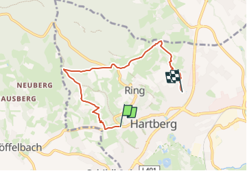
![](/images/other/stat-length.png)
![Trail On foot Hartberg - Hartberger Höhenweg - Photo](https://media.geolcdn.com/t/1900/400/1db5baee-f037-496a-b33d-301fc2e0a355.jpeg&format=pjpeg&maxdim=2)
Hartberger Höhenweg
SityTrail - itinéraires balisés pédestres
Tous les sentiers balisés d’Europe GUIDE+
![Length](/images/other/stat-length.png)
![Max alt](https://static1.geolcdn.com/siteimages/upload/files/1508320355ic_sort_altitude_max_24dp.png)
![Uphill gradient](https://static1.geolcdn.com/siteimages/upload/files/1508320355ic_sort_den_pos_24dp.png)
![Km-Effort](/images/other/stat-length.png)
![Min alt](https://static1.geolcdn.com/siteimages/upload/files/1508320355ic_sort_altitude_min_24dp.png)
![Downhill gradient](https://static1.geolcdn.com/siteimages/upload/files/1508320355ic_sort_den_neg_24dp.png)
![Boucle](https://static1.geolcdn.com/siteimages/upload/files/16400158638029165_repeat_loop_refresh_sync_direction_icon.png)
![On foot](https://static1.geolcdn.com/sitytour/trail-icons/100.png)
1h53
Difficulty : Easy
![Scan this QR Code to open this trail in the SityTrail application](https://capi.geolives.com/qq0zvz2zws4bq2lad0pu/sitytour/trails/3128255/qr.png?size=200)
FREE GPS app for hiking
About
Trail On foot of 5.4 km to be discovered at Styria, Bezirk Hartberg-Fürstenfeld, Hartberg. This trail is proposed by SityTrail - itinéraires balisés pédestres.
Description
Hartberg - Umgebung Styria: Tours - Austria - Hiking
Website: http://www.bergfex.com/sommer/hartberg-umgebung/touren/wandern/#/sommer/steiermark/touren/wanderung/55629,stadtrundweg/
Positioning
Comments
Trails nearby
![Trail On foot Hartberg Umgebung - Löffelbach - Villa Rustica - Burg Neuberg - Sportplatz Schildbach - Löffenbach (II) - Photo](https://media.geolcdn.com/t/375/260/435820f5-6204-4c3d-a056-0ebf7fea6b43.jpeg&format=jpg&maxdim=2)
![On foot On foot](https://static1.geolcdn.com/sitytour/trail-icons/100.png)
On foot
![](/images/other/stat-length.png)
![](https://static1.geolcdn.com/siteimages/upload/files/16400158638029165_repeat_loop_refresh_sync_direction_icon.png)
![Trail On foot Hartberg Umgebung - Löffelbach - Villa Rustica - Burg Neuberg - Löffenbach (I) - Photo](https://media.geolcdn.com/t/375/260/7662d677-9ccc-4427-a9eb-a8c9a1c8776e.jpeg&format=jpg&maxdim=2)
![On foot On foot](https://static1.geolcdn.com/sitytour/trail-icons/100.png)
On foot
![](/images/other/stat-length.png)
![](https://static1.geolcdn.com/siteimages/upload/files/16400158638029165_repeat_loop_refresh_sync_direction_icon.png)
![Trail On foot Hartberg Umgebung - Löffelbach - Häckerberg - Flattendorf-Aue - St. Anna - Löffelbach (IV) - Photo](https://media.geolcdn.com/t/375/260/435820f5-6204-4c3d-a056-0ebf7fea6b43.jpeg&format=jpg&maxdim=2)
![On foot On foot](https://static1.geolcdn.com/sitytour/trail-icons/100.png)
On foot
![](/images/other/stat-length.png)
![](https://static1.geolcdn.com/siteimages/upload/files/16400158638029165_repeat_loop_refresh_sync_direction_icon.png)
![Trail On foot Hartberg Umgebung - Kurweg (V) - Photo](https://media.geolcdn.com/t/375/260/7a813856-0bc8-49ef-8b6f-334a63796daa.jpeg&format=jpg&maxdim=2)
![On foot On foot](https://static1.geolcdn.com/sitytour/trail-icons/100.png)
On foot
![](/images/other/stat-length.png)
![](https://static1.geolcdn.com/siteimages/upload/files/16400158638029165_repeat_loop_refresh_sync_direction_icon.png)
![Trail On foot Kaindorf - Kaindorfer Marterlweg - Photo](https://media.geolcdn.com/t/375/260/118d47fd-a5b4-48fe-838c-8608917e2a50.jpeg&format=jpg&maxdim=2)
![On foot On foot](https://static1.geolcdn.com/sitytour/trail-icons/100.png)
On foot
![](/images/other/stat-length.png)
![](https://static1.geolcdn.com/siteimages/upload/files/16400158638029165_repeat_loop_refresh_sync_direction_icon.png)
![Trail On foot Hartberg - Ringwarte Brühl Spielstätte - Photo](https://media.geolcdn.com/t/375/260/20adf768-0326-43f9-a7e2-11fb5c56a5e5.jpeg&format=jpg&maxdim=2)
![On foot On foot](https://static1.geolcdn.com/sitytour/trail-icons/100.png)
On foot
![](/images/other/stat-length.png)
![](https://static1.geolcdn.com/siteimages/upload/files/16400158638029165_repeat_loop_refresh_sync_direction_icon.png)
![Trail On foot Greinbach - Penzendorf Wanderweg 7 - Photo](https://media.geolcdn.com/t/375/260/b338fd4d-6e8f-49a9-96a7-52c05ab16757.jpeg&format=jpg&maxdim=2)
![On foot On foot](https://static1.geolcdn.com/sitytour/trail-icons/100.png)
On foot
![](/images/other/stat-length.png)
![](https://static1.geolcdn.com/siteimages/upload/files/16400158638029165_repeat_loop_refresh_sync_direction_icon.png)
![Trail On foot Greinbach - Penzendorf Wanderweg 6 - Photo](https://media.geolcdn.com/t/375/260/b338fd4d-6e8f-49a9-96a7-52c05ab16757.jpeg&format=jpg&maxdim=2)
![On foot On foot](https://static1.geolcdn.com/sitytour/trail-icons/100.png)
On foot
![](/images/other/stat-length.png)
![](https://static1.geolcdn.com/siteimages/upload/files/16400158638029165_repeat_loop_refresh_sync_direction_icon.png)
![Trail On foot Greinbach - Penzendorf Wanderweg 2 - Photo](https://media.geolcdn.com/t/375/260/ceb5d8fa-820c-4395-b446-ab31f13ac06d.jpeg&format=jpg&maxdim=2)
![On foot On foot](https://static1.geolcdn.com/sitytour/trail-icons/100.png)
On foot
![](/images/other/stat-length.png)
![](https://static1.geolcdn.com/siteimages/upload/files/16400158638029165_repeat_loop_refresh_sync_direction_icon.png)