![](/images/other/stat-length.png)
![Trail On foot Bad Schallerbach - Landlweg - Photo](https://media.geolcdn.com/t/1900/400/b7cd149e-6447-4e2b-bf2a-fb2ae8d85363.jpeg&format=pjpeg&maxdim=2)
Landlweg
SityTrail - itinéraires balisés pédestres
Tous les sentiers balisés d’Europe GUIDE+
![Length](/images/other/stat-length.png)
Length
8.8 km
![Max alt](https://static1.geolcdn.com/siteimages/upload/files/1508320355ic_sort_altitude_max_24dp.png)
Max alt
424 m
![Uphill gradient](https://static1.geolcdn.com/siteimages/upload/files/1508320355ic_sort_den_pos_24dp.png)
Uphill gradient
206 m
![Km-Effort](/images/other/stat-length.png)
Km-Effort
11.4 km
![Min alt](https://static1.geolcdn.com/siteimages/upload/files/1508320355ic_sort_altitude_min_24dp.png)
Min alt
304 m
![Downhill gradient](https://static1.geolcdn.com/siteimages/upload/files/1508320355ic_sort_den_neg_24dp.png)
Downhill gradient
176 m
![Boucle](https://static1.geolcdn.com/siteimages/upload/files/16400158638029165_repeat_loop_refresh_sync_direction_icon.png)
Boucle
No
Signpost
Creation date :
2022-02-16 16:52:19.798
Updated on :
2022-03-03 13:23:30.612
![On foot](https://static1.geolcdn.com/sitytour/trail-icons/100.png)
2h35
Difficulty : Easy
![Scan this QR Code to open this trail in the SityTrail application](https://capi.geolives.com/qq0zvz2zws4bq2lad0pu/sitytour/trails/3128169/qr.png?size=200)
FREE GPS app for hiking
About
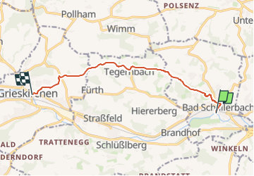
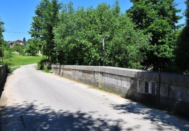
Trail On foot of 8.8 km to be discovered at Upper Austria, Bezirk Grieskirchen, Bad Schallerbach. This trail is proposed by SityTrail - itinéraires balisés pédestres.
Description
Symbol: rot-weiß manchmal mit Aufschrift 34, rot-weiß-rot mit Aufschrift 34 und auch gelbe Tafeln mit Aufschrift "34 Landlweg"
Positioning
Country:
Austria
Region :
Upper Austria
Department/Province :
Bezirk Grieskirchen
Municipality :
Bad Schallerbach
Location:
Unknown
Start:(Dec)
Start:(UTM)
419671 ; 5342263 (33U) N.
Comments
Trails nearby
![Trail On foot Pollham - Pollhamer Marterlroas - Photo](https://media.geolcdn.com/t/375/260/0c0fbf45-1249-4730-b149-ad5ac7505d7c.jpeg&format=jpg&maxdim=2)
![On foot On foot](https://static1.geolcdn.com/sitytour/trail-icons/100.png)
Pollhamer Marterlroas
On foot
Easy
Pollham,
Upper Austria,
Bezirk Grieskirchen,
Austria
![](/images/other/stat-length.png)
9.7 km | 12.4 km-effort
2h 49min
![](https://static1.geolcdn.com/siteimages/upload/files/16400158638029165_repeat_loop_refresh_sync_direction_icon.png)
Yes
![Trail On foot Sankt Marienkirchen an der Polsenz - Weberbartlweg - Photo](https://media.geolcdn.com/t/375/260/7baeb0b9-bae3-4b09-a4cf-579051044a08.jpeg&format=jpg&maxdim=2)
![On foot On foot](https://static1.geolcdn.com/sitytour/trail-icons/100.png)
Weberbartlweg
On foot
Easy
Sankt Marienkirchen an der Polsenz,
Upper Austria,
Bezirk Eferding,
Austria
![](/images/other/stat-length.png)
8.4 km | 10.6 km-effort
2h 24min
![](https://static1.geolcdn.com/siteimages/upload/files/16400158638029165_repeat_loop_refresh_sync_direction_icon.png)
Yes
![Trail On foot Sankt Marienkirchen an der Polsenz - Samareiner Jakobsweg - Photo](https://media.geolcdn.com/t/375/260/4b5e9188-a129-4d6a-ba23-23aad07c865d.jpeg&format=jpg&maxdim=2)
![On foot On foot](https://static1.geolcdn.com/sitytour/trail-icons/100.png)
Samareiner Jakobsweg
On foot
Easy
Sankt Marienkirchen an der Polsenz,
Upper Austria,
Bezirk Eferding,
Austria
![](/images/other/stat-length.png)
9.1 km | 11.8 km-effort
2h 40min
![](https://static1.geolcdn.com/siteimages/upload/files/16400158638029165_repeat_loop_refresh_sync_direction_icon.png)
Yes
![Trail On foot Sankt Marienkirchen an der Polsenz - Römerweg - Photo](https://media.geolcdn.com/t/375/260/7baeb0b9-bae3-4b09-a4cf-579051044a08.jpeg&format=jpg&maxdim=2)
![On foot On foot](https://static1.geolcdn.com/sitytour/trail-icons/100.png)
Römerweg
On foot
Easy
Sankt Marienkirchen an der Polsenz,
Upper Austria,
Bezirk Eferding,
Austria
![](/images/other/stat-length.png)
7.6 km | 10.3 km-effort
2h 21min
![](https://static1.geolcdn.com/siteimages/upload/files/16400158638029165_repeat_loop_refresh_sync_direction_icon.png)
Yes
![Trail On foot Scharten - Naturparkhöhenweg - Photo](https://media.geolcdn.com/t/375/260/5100edf3-1933-4270-8992-a07e11576fa7.jpeg&format=jpg&maxdim=2)
![On foot On foot](https://static1.geolcdn.com/sitytour/trail-icons/100.png)
Naturparkhöhenweg
On foot
Easy
Scharten,
Upper Austria,
Bezirk Eferding,
Austria
![](/images/other/stat-length.png)
5.8 km | 8.1 km-effort
1h 49min
![](https://static1.geolcdn.com/siteimages/upload/files/16400158638029165_repeat_loop_refresh_sync_direction_icon.png)
Yes
![Trail On foot Sankt Marienkirchen an der Polsenz - Mostkulturweg - Photo](https://media.geolcdn.com/t/375/260/7baeb0b9-bae3-4b09-a4cf-579051044a08.jpeg&format=jpg&maxdim=2)
![On foot On foot](https://static1.geolcdn.com/sitytour/trail-icons/100.png)
Mostkulturweg
On foot
Easy
Sankt Marienkirchen an der Polsenz,
Upper Austria,
Bezirk Eferding,
Austria
![](/images/other/stat-length.png)
5.1 km | 5.9 km-effort
1h 20min
![](https://static1.geolcdn.com/siteimages/upload/files/16400158638029165_repeat_loop_refresh_sync_direction_icon.png)
Yes
![Trail On foot Sankt Marienkirchen an der Polsenz - Lengauerweg - Photo](https://media.geolcdn.com/t/375/260/7baeb0b9-bae3-4b09-a4cf-579051044a08.jpeg&format=jpg&maxdim=2)
![On foot On foot](https://static1.geolcdn.com/sitytour/trail-icons/100.png)
Lengauerweg
On foot
Easy
Sankt Marienkirchen an der Polsenz,
Upper Austria,
Bezirk Eferding,
Austria
![](/images/other/stat-length.png)
7.8 km | 10.4 km-effort
2h 21min
![](https://static1.geolcdn.com/siteimages/upload/files/16400158638029165_repeat_loop_refresh_sync_direction_icon.png)
Yes
![Trail On foot Scharten - Hubertusrundweg - Photo](https://media.geolcdn.com/t/375/260/925e9619-4d5b-4780-80f4-03d3b64787a3.jpeg&format=jpg&maxdim=2)
![On foot On foot](https://static1.geolcdn.com/sitytour/trail-icons/100.png)
Hubertusrundweg
On foot
Easy
Scharten,
Upper Austria,
Bezirk Eferding,
Austria
![](/images/other/stat-length.png)
3.3 km | 4.9 km-effort
1h 7min
![](https://static1.geolcdn.com/siteimages/upload/files/16400158638029165_repeat_loop_refresh_sync_direction_icon.png)
Yes
![Trail On foot Krenglbach - Krenglbacher Bahnweg 5 - Photo](https://media.geolcdn.com/t/375/260/9c578dcd-28fb-4b2b-ace8-9864effced42.jpeg&format=jpg&maxdim=2)
![On foot On foot](https://static1.geolcdn.com/sitytour/trail-icons/100.png)
Krenglbacher Bahnweg 5
On foot
Easy
Krenglbach,
Upper Austria,
Bezirk Wels-Land,
Austria
![](/images/other/stat-length.png)
7.3 km | 8.7 km-effort
1h 59min
![](https://static1.geolcdn.com/siteimages/upload/files/16400158638029165_repeat_loop_refresh_sync_direction_icon.png)
Yes