Trail On foot Unknown - 
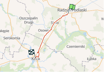
Szlak im. gen. Kleeberga - Photo

Tous les sentiers balisés d’Europe PRO

© OpenStreetMap contributors
Length
Length
22 km
Max alt
Max alt
167 m
Uphill gradient
Uphill gradient
141 m
Km-Effort
Km-Effort  
24 km
Min alt
Min alt
133 m
Downhill gradient
Downhill gradient
145 m
Boucle
Boucle
No
Signpost
Signpost
Creation date :
2022-02-16 16:47:19.054
Updated on :
2022-03-08 13:03:19.114

(0 Reviews)

On foot
On foot
5h22
Difficulty : Medium

Scan this QR Code to open this trail in the SityTrail application

FREE GPS app for hiking

Logo SityTrail SityTrail

IGN / Geographical institutes

Download SityTrail from the App Store Download SityTrail from Google Play

Logo SityTrail SityTrail World

The world is yours!

Download SityTrail from the App Store Download SityTrail from Google Play Download SityTrail on Huawei AppGallery

About

Trail On foot of 22 km to be discovered at Lublin Voivodeship, Radzyń Podlaski County. This trail is proposed by SityTrail - itinéraires balisés pédestres.

Description

Szlak składa się z trzech odcinków: zielony Dęblin-Kock, czerwony Kock-Radzyń i żółty Radzyń-Czemierniki. Odcinek czerwony jest słabo oznakowany i porwany, bo po budowie obwodnicy Kocka nie został poprawiony(już jest popra). Przebieg w Radzyniu niejasny.

Photos

Positioning

Country:
Poland
Region :
Lublin Voivodeship
Department/Province :
Radzyń Podlaski County
Municipality :
Unknown
Location:
Unknown
Start:(UTM)
610627 ; 5736959 (34U) N.

Trails nearby


Close
My subscriptions