Trail On foot Unknown - Szlak Jezior Drawskich - Photo

Tous les sentiers balisés d’Europe GUIDE+

© OpenStreetMap contributors
Length
Length
79 km
Max alt
Max alt
156 m
Uphill gradient
Uphill gradient
767 m
Km-Effort
Km-Effort  
89 km
Min alt
Min alt
77 m
Downhill gradient
Downhill gradient
766 m
Boucle
Boucle
Yes
Signpost
Signpost
Creation date :
2022-02-16 16:44:29.761
Updated on :
2022-03-08 12:50:16.868

(0 Reviews)

On foot
On foot
20h12
Difficulty : Very difficult

Scan this QR Code to open this trail in the SityTrail application

FREE GPS app for hiking

Logo SityTrail SityTrail

IGN / Geographical institutes

Download SityTrail from the App Store Download SityTrail from Google Play

Logo SityTrail SityTrail World

The world is yours!

Download SityTrail from the App Store Download SityTrail from Google Play Download SityTrail on Huawei AppGallery

About

Trail On foot of 79 km to be discovered at West Pomeranian Voivodeship, Drawsko County. This trail is proposed by SityTrail - itinéraires balisés pédestres.

Description

Szlak można pokonać rowerem, ale w miejscach niedostępnych lub trudno dostępnych należy skorzystać z proponowanych w tekście objazdów.

Symbol: zielony pasek

Elevation profile

Photos

Positioning

Country:
Poland
Region :
West Pomeranian Voivodeship
Department/Province :
Drawsko County
Municipality :
Unknown
Location:
Unknown
Start:(UTM)
556888 ; 5927470 (33U) N.

Trails nearby

Trail On foot Łobez - Lobeliowe Jezioro i Wilczy Gród - Photo
On foot
GUIDE+

On foot

Easy
Łobez, West Pomeranian Voivodeship, Łobez County, Poland
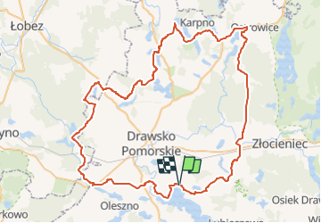
5.1 km | 5.8 km-effort
1h 19min
No
Trail On foot  - Szlak pieszy zielony - Photo
On foot
GUIDE+

On foot

Easy
, West Pomeranian Voivodeship, Wałcz County, Poland
12.2 km | 13.9 km-effort
3h 9min
No


Close
My subscriptions