Trail On foot Tragwein - Mühlviertler Quell-Wanderweg - Photo

Mühlviertler Quell-Wanderweg

Tous les sentiers balisés d’Europe GUIDE+

© OpenStreetMap contributors
Length
Length
16.4 km
Max alt
Max alt
630 m
Uphill gradient
Uphill gradient
541 m
Km-Effort
Km-Effort  
24 km
Min alt
Min alt
435 m
Downhill gradient
Downhill gradient
538 m
Boucle
Boucle
No
Signpost
Signpost
Creation date :
2022-02-16 16:41:34.557
Updated on :
2022-03-03 10:33:38.712

(0 Reviews)

On foot
On foot
5h21
Difficulty : Medium

Scan this QR Code to open this trail in the SityTrail application

FREE GPS app for hiking

Logo SityTrail SityTrail

IGN / Geographical institutes

Download SityTrail from the App Store Download SityTrail from Google Play

Logo SityTrail SityTrail World

The world is yours!

Download SityTrail from the App Store Download SityTrail from Google Play Download SityTrail on Huawei AppGallery

About

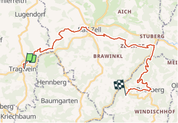
Trail On foot of 16.4 km to be discovered at Upper Austria, Bezirk Freistadt, Tragwein. This trail is proposed by SityTrail - itinéraires balisés pédestres.

Description

Symbol: weiße Tafel mit blau-grünem Q und in schwarz der Text Mühlviertler Quell-Wanderweg

Elevation profile

Photos

Positioning

Country:
Austria
Region :
Upper Austria
Department/Province :
Bezirk Freistadt
Municipality :
Tragwein
Location:
Unknown
Start:(UTM)
472092 ; 5353183 (33U) N.

Trails nearby

Trail On foot Bad Zell - Bad Zell - Ruttenstein - Photo
On foot
GUIDE+

On foot

Easy
Bad Zell, Upper Austria, Bezirk Freistadt, Austria
4 km | 5.7 km-effort
1h 17min
No


Close
My subscriptions