![](/images/other/stat-length.png)
![Trail On foot Allerheiligen im Mühlkreis - Alpenvereinsweg - Photo](https://media.geolcdn.com/t/1900/400/ext.pjpeg?maxdim=2&url=https%3A%2F%2Fstatic1.geolcdn.com%2Fsiteimages%2Fupload%2Ffiles%2F1545311037marcheuse_200dpi.jpg)
Alpenvereinsweg
SityTrail - itinéraires balisés pédestres
Tous les sentiers balisés d’Europe GUIDE+
![Length](/images/other/stat-length.png)
Length
3.2 km
![Max alt](https://static1.geolcdn.com/siteimages/upload/files/1508320355ic_sort_altitude_max_24dp.png)
Max alt
468 m
![Uphill gradient](https://static1.geolcdn.com/siteimages/upload/files/1508320355ic_sort_den_pos_24dp.png)
Uphill gradient
135 m
![Km-Effort](/images/other/stat-length.png)
Km-Effort
4.7 km
![Min alt](https://static1.geolcdn.com/siteimages/upload/files/1508320355ic_sort_altitude_min_24dp.png)
Min alt
327 m
![Downhill gradient](https://static1.geolcdn.com/siteimages/upload/files/1508320355ic_sort_den_neg_24dp.png)
Downhill gradient
59 m
![Boucle](https://static1.geolcdn.com/siteimages/upload/files/16400158638029165_repeat_loop_refresh_sync_direction_icon.png)
Boucle
No
Signpost
Creation date :
2022-02-16 16:41:12.773
Updated on :
2022-03-03 10:29:57.506
![On foot](https://static1.geolcdn.com/sitytour/trail-icons/100.png)
1h04
Difficulty : Easy
![Scan this QR Code to open this trail in the SityTrail application](https://capi.geolives.com/qq0zvz2zws4bq2lad0pu/sitytour/trails/3127504/qr.png?size=200)
FREE GPS app for hiking
About
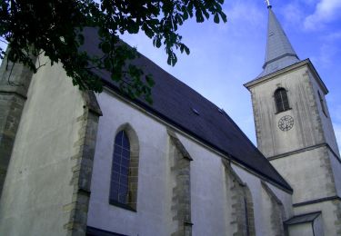
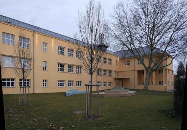
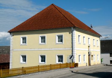
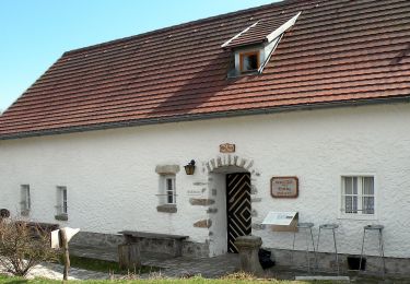
Trail On foot of 3.2 km to be discovered at Upper Austria, Bezirk Perg, Allerheiligen im Mühlkreis. This trail is proposed by SityTrail - itinéraires balisés pédestres.
Description
Symbol: gelbe Ziffer 3 auf schwarzem Kreis auf gelbem Grund, daneben die Bezeichnung Alpenvereinsweg in schwarzer Schrift
Positioning
Country:
Austria
Region :
Upper Austria
Department/Province :
Bezirk Perg
Municipality :
Allerheiligen im Mühlkreis
Location:
Unknown
Start:(Dec)
Start:(UTM)
472971 ; 5345842 (33U) N.
Comments
Trails nearby
![Trail On foot Windhaag bei Perg - Falkensteinweg - Photo](https://media.geolcdn.com/t/375/260/78efe76c-2fc0-455b-9477-e99a631d349b.jpeg&format=jpg&maxdim=2)
![On foot On foot](https://static1.geolcdn.com/sitytour/trail-icons/100.png)
Falkensteinweg
On foot
Easy
Windhaag bei Perg,
Upper Austria,
Bezirk Perg,
Austria
![](/images/other/stat-length.png)
10.6 km | 15.4 km-effort
3h 30min
![](https://static1.geolcdn.com/siteimages/upload/files/16400158638029165_repeat_loop_refresh_sync_direction_icon.png)
Yes
![Trail On foot Perg - Naturfreundeweg - Photo](https://media.geolcdn.com/t/375/260/0257230b-a569-485f-9136-ca75baadabe7.jpeg&format=jpg&maxdim=2)
![On foot On foot](https://static1.geolcdn.com/sitytour/trail-icons/100.png)
Naturfreundeweg
On foot
Easy
Perg,
Upper Austria,
Bezirk Perg,
Austria
![](/images/other/stat-length.png)
6.5 km | 9.3 km-effort
2h 6min
![](https://static1.geolcdn.com/siteimages/upload/files/16400158638029165_repeat_loop_refresh_sync_direction_icon.png)
Yes
![Trail On foot Windhaag bei Perg - Route IV Schwertmühle - Photo](https://media.geolcdn.com/t/375/260/21383be9-9604-4cab-b26e-efc7d15a0996.jpeg&format=jpg&maxdim=2)
![On foot On foot](https://static1.geolcdn.com/sitytour/trail-icons/100.png)
Route IV Schwertmühle
On foot
Easy
Windhaag bei Perg,
Upper Austria,
Bezirk Perg,
Austria
![](/images/other/stat-length.png)
6.4 km | 9.3 km-effort
2h 6min
![](https://static1.geolcdn.com/siteimages/upload/files/16400158638029165_repeat_loop_refresh_sync_direction_icon.png)
Yes
![Trail On foot Windhaag bei Perg - Route III Hausbergbach - Photo](https://media.geolcdn.com/t/375/260/7c7eb67f-f880-4c43-9835-70b1a007e6a8.jpeg&format=jpg&maxdim=2)
![On foot On foot](https://static1.geolcdn.com/sitytour/trail-icons/100.png)
Route III Hausbergbach
On foot
Easy
Windhaag bei Perg,
Upper Austria,
Bezirk Perg,
Austria
![](/images/other/stat-length.png)
4.5 km | 6.5 km-effort
1h 29min
![](https://static1.geolcdn.com/siteimages/upload/files/16400158638029165_repeat_loop_refresh_sync_direction_icon.png)
Yes
![Trail On foot Windhaag bei Perg - Route I Enzmilner Kulturwanderweg - Photo](https://media.geolcdn.com/t/375/260/7c7eb67f-f880-4c43-9835-70b1a007e6a8.jpeg&format=jpg&maxdim=2)
![On foot On foot](https://static1.geolcdn.com/sitytour/trail-icons/100.png)
Route I Enzmilner Kulturwanderweg
On foot
Easy
Windhaag bei Perg,
Upper Austria,
Bezirk Perg,
Austria
![](/images/other/stat-length.png)
11.9 km | 16.5 km-effort
3h 45min
![](https://static1.geolcdn.com/siteimages/upload/files/16400158638029165_repeat_loop_refresh_sync_direction_icon.png)
Yes
![Trail On foot Windhaag bei Perg - Naarntalweg - Photo](https://media.geolcdn.com/t/375/260/8eab79cc-fd61-4c8d-9698-e11ee7b3c5d4.jpeg&format=jpg&maxdim=2)
![On foot On foot](https://static1.geolcdn.com/sitytour/trail-icons/100.png)
Naarntalweg
On foot
Easy
Windhaag bei Perg,
Upper Austria,
Bezirk Perg,
Austria
![](/images/other/stat-length.png)
4 km | 5.7 km-effort
1h 18min
![](https://static1.geolcdn.com/siteimages/upload/files/16400158638029165_repeat_loop_refresh_sync_direction_icon.png)
No
![Trail On foot Perg - Kugelmanderlweg - Photo](https://media.geolcdn.com/t/375/260/97530db8-585c-4e4f-8059-9e20065e0a9c.jpeg&format=jpg&maxdim=2)
![On foot On foot](https://static1.geolcdn.com/sitytour/trail-icons/100.png)
Kugelmanderlweg
On foot
Easy
Perg,
Upper Austria,
Bezirk Perg,
Austria
![](/images/other/stat-length.png)
9.1 km | 12 km-effort
2h 43min
![](https://static1.geolcdn.com/siteimages/upload/files/16400158638029165_repeat_loop_refresh_sync_direction_icon.png)
Yes